
-
 8209 Hits
-
 89.39% Score
-
 29 Votes
|
|
Mountain/Rock |
|---|---|
|
|
45.05515°N / 6.42503°E |
|
|
Hautes Alpes |
|
|
Hiking, Trad Climbing, Sport Climbing |
|
|
Summer |
|
|
10072 ft / 3070 m |
|
|
Overview
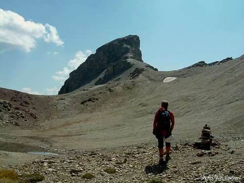
Tour Termier 3070 m.
A magnificent peak "Dolomites-style" far away from the Dolomites
Tour Termier is a beautiful and stunning limestone tower lying immediately South to the imposing Grand Galibier, in the West-end of the Cerces Massif, a small group located in the French Western Alps, North-West to the town of Briançon and close to the France-Italy border.
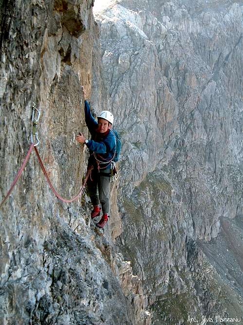
The Cerces massif offers several superb and often difficult climbing routes, well-known also by the Italian climbers by means of their relative closeness to the Piedmont region and the town of Turin. On Tour Termier the limestone is truly excellent and spectacular, sometimes reddish and finely carved. On the West and South walls there are many excellent modern routes.

Getting There

Road access
The starting point of the approach-trail is situated along the road to Col du Galibier 2642 m, which starts from Col du Lautaret 2057 m, an important road pass on the road N91, connecting Briançon with Grenoble.
- From Turin (Italy)
Follow the A32-E70 Motorway entering Val di Susa and exit to Oulx, reach Cesana Torinese and Claviere, then Colle del Monginevro m. 1854, on Italy-France border; from here the road N94 descends to the town of Briançon. From Briançon follow the road N91 towards Val Guisane, reaching Chantemerle and Monetier les Bains, then the Col du Lautaret 2057 m; leave the main road and turn to right following the road to Col du Galibier. Park the car in a pull-out at 2514 m, near the last hairpin before reaching Col du Galibier (about 130 km. from Turin).
- From Grenoble (France)
Follow the road N85 to Vizille, then the road N91 rising to Col du Lautaret; reach the Col du Lautaret 2057 m and from here leave the main road, turning to the left on the road to Col du Galibier. Parking in a pull-out at 2514 m, near the last hairpin before reaching Col du Galibier (about 100 km. from Grenoble).

Walking approach to West and South walls
From the hairpin a mainly level trail (blue marks) is starting towards East, leading below the tower after about 2 km. A steep scree is rising to the starting point of the routes. About 1 hour from the pull-out.
West and South faces routes overview
W and S faces routes overview (from left to right), French Scale:

West Face
- Voie du Ponant TD, 5b, 6a/A1, 200 trad
- Boucs en stocks (Termi-Née) TD+, 6b+ (6a+ A0), 300 m, bolts
- Treize à la douzaine TD-, 6a (5c and A0), 250 m, bolts
- Ponant Neuf TD, 6a+, 5c obbl., 300 m.. bolts
- Le Feu Sacré ED, 7a, 6a+ obbl. 300 m., bolts
- Oxygène ED, 7c, 6c obbl., expo, bolts
- Les Guepes ED, 6b, A2, 200 m., trad route, pegs
South Face
- L’incontinent ABO-, 7b+, 6b obbl., 220 m., bolts
- Daisy chienne ED4, 7b+ (6c+ A0), 260 m., bolts
- Ici mieux qu’en face ABO-, 7b+, 6c+ obbl., 250 m., bolts
- L'usure du temps ED, 7c+ (6b A0), 300 m., bolts
- Marmotta Impazzita ED-, 6c, 6b obbl., 300 m., bolts
- Allo la Terre TD, 6a, 5c+ obbl., 350 m., bolts
- Termier-Tière D+, 6a (5c+ A0), 300 m., bolts
Ponant Neuf, a great climb

Ponant Neuf route report – French Scale
Summit altitude: 3070 m
TD, max 6a+, 5c obbl.
Climbing length: 300 m
Exposure: W
Equipment: bolts
First ascent: Jean-Michel Cambon and Gerard Fiaschi 1999
Starting point: last hairpin on the road to Col du Galibier
A spectacular route on excellent limestone; the rock is grey and reddish, finely carven with surprising inlay. The climb, running on a very steep wall, is always athletic and highly satisfactory. This wall, facing West, may be sometimes a bit cold, as a matter of fact the sun is lightening the route in the very first afternoon. West face, on the left-hand side, and South face, on the right one, are divided by an obvious great and white corner. A curious particular: marmots living around the tower are always hungry and greedy, eating every objects they can get.
From the upper scree skirt the tower’s basal rocks towards left, reaching the starting point of the route, situated on the left of the great white corner, and on the left of a great flake, which is the starting point of the very hard “Le Feu Sacré”...
L1 – A short pitch on a little chimney-crack and a short wall. 3b, then 4b.
L2 – Another short wall (5c), then a steep slab, slanting to left (5a) and leading to a lightly overhanging wall. Climb the wall and a short flake, 5c then 5a.
L3 – Climb a slab with few holds, 5b+, then a crack slanting left, 5a, and finally traverse left on a delicate slab, 5c.
L4 – Climb a sequence of little walls on the left-hand side of a pillar, 4c; some easy steps lead to a belay on a ledge below another pillar, cut on the right by a chimney-gully.
L5 – Climb the pillar 4b, then traverse the gully towards right and climb a steep grey wall, 5b+, then 6a; reach a grassy ramp and climb it to a stance (common belay with “Le Feu Sacré”).
L6 – Climb a wall slants to left, then traverse left 12 m. following a narrow and shallow ledge, 5b then 4c. Short pitch.
L7 – A grey slab, 5c+; belay inside a corner. Another short pitch.
L8 – Climb a steep reddish wall on the right of the corner, then go slants to right, 5b.
L9 – Climb a narrow corner, or its right face, 4c, then 5b, then some short steep walls, 5b.
L10 – Towards right climb a steep slab, 5b+, then a lightly overhanging wall, 5c; climb a little overhang, 6a, a grey slab, 5b, and finally a steep wall, 6a+, crux. Belay on a ledge.
L11 – Climb a short steep wall at first towards right, 6a again, then straight, 5b. Enter a corner and climb it getting to the summit. 5a.
Descent - It's also possible rapping along an equipped line near “Ponant Neuf”, anyhow the best solution is the descent by walking. Head Eastwards – the opposite side of the climb up - and do a short downclimb (rapping possible), then continue by walk leftward (North) entering a valley and following it to Col Termier. From the col scramble down the West side (exposed and steep trail) reaching the basal scree. 1,45 hour from the summit to the parking. This descent is not advisable in early summer, when Col Termier is snow-covered.
Red tape

No particulary restrictions in climbing and hiking.
When to climb
West face is sometimes cold. Best season goes from July to September.
Where to stay
Gites d' Etape in Val Guisane:
- "La ferme des Boussardes" near Le Lauzet Phone: 0033 492 244213
- "Le Flourou" Monetier les Bains Phone: 0033 492 244113
Several possibilities of accomodation in Briançon (hotels, gites d'etape, renting rooms and campings).
Meteo
Meteo France
Meteo Regione Piemonte
Guidebooks and maps


"Selected Plaisir Climbs Of Switzerland 2012" by Sandro von Känel - Edition Filidor 2012 - This guidebook features 115 of the most beautiful Plaisir routes (multi-pitch 4b – 6c) from the French Dauphine in the Southwest to the Alpstein massif in the Northeast. Includes many photos and exacting topos by the author who has personally climbed every route in 2011
“Oisans Noveau, Oisans Sauvage - Livre Est” by Jean Michel Cambon
"Alpes Françaises du Nord - Escalade Plaisir" by Hervé Galley - Edition Olizane
Maps
"Ecrins - Haut Dauphiné" 1:50.000 Ed. Didier Richard
"Valloire - Aiguilles d'Arves - Col du Galibier" - IGN 3435ET
"Névache - Mont Thabor - Cols du Galibier et du Lautaret" - IGN 3535OT