
-
 6151 Hits
-
 84.27% Score
-
 18 Votes
|
|
Mountain/Rock |
|---|---|
|
|
46.68992°N / 13.06041°E |
|
|
Hiking, Scrambling, Skiing |
|
|
Spring, Summer, Fall, Winter |
|
|
7464 ft / 2275 m |
|
|
Overview
 Torkofel group from Spitzkofel
 Jauken group from Polinik
 Jaukenhoehe from Torkofel
The Gailtal Torkofel
Be aware that besides the Torkofel described on this page, there's another Torkofel / Sas dla Porta in Dolomites!
A bit of geography
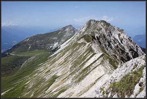
Torkofel is a nice summit in Gailtal Alps / Ziljske Alpe, the highest in its small group above Jauken meadow. Jauken group is a small mountain massif between Gailbergsattel, 981 m, on the west and Jaukensattel, 1615 m, on the east. If Lienz Dolomites on the west are quite a separate group, then Reisskofel, rising east of Jauken group, has a similar character. As other Gailtal Alps east of Gailbergsattel, also Jauken group has a form of a nice ridge. At least in its central part, around Torkofel, several summits are only a little exceeding by the altitude the high running ridge. The summits from west to east are the following: Jaukenstoeckl, 2202 m, Jaukenhoehe, 2234 m, Torkofel, 2275 m, Mitterkofel, 2247 m, Spitzkofel (Dreischneid), 2227 m. And finally to mention - towards the N-NE Torkofel sends a strong side ridge. The name Torkofel comes from a natural window in the west ridge.
Finally, let's mention also the much less visited northern side. One interesting feature there is the 3 km long rubble ravine, called Gießgraben.
First ascent
The first recorded ascent on Torkofel was done in 1853 by by Johann Festin von Wald and Paul Grohmann.
Mining area since pre-historic times
The summits of Torkofel group are made of limestone, similarly as on the nearby Reisskofel. But geological landscape must be more diverse, as all around the main summits once there were many mines of iron, led, zinc and copper. On the area above Dellach, on the southern side of massif, still in the 18th century more than 300 miners were working, but today all operations are closed down. In Dellach there is a GeoPark, where on 120 square meters you can learn about milions of years of geological history. Otherwise, the highest parts of the main ridge are built of grey Wetterstein limestone, partially also of dark grey plate limestone and somewhere mixed with dolomite.
Jaukenalm
Another very attractive characteristic of the central Jauken group is a very broad alpine meadow on the south. Also the meadow is called Jauken and it gave name to the whole area. So, on the altitude between 1800 m and 1900 m along the whole southern flank of the narrow Torkofel massif a broad terrace runs, and also nowadays during summer a lot of cattle can be seen there. The hut on Jaukenalm can be reached by a mountain road, but it is closed for public traffic.
Geißlochklamm
North of Spitzkofel (and of Amlacher Alm), just above the valley of Drau / Drava, there's an interesting gorge, arranged for tourist visit. It's appropriate also for families and excells with wild scenery of bizzare rocks. 1 hour for the tour.
Summit views
 Torkofel east view
As Gailtal Alps / Ziljske Alpe summits stand remotely from each other and as two broad valley delimit them from the neighbouring groups, from Torkofel one can enjoy a very broad panorama. Views fly along the chain itself - on the eastern side Reisskofel is the most attractive summit, and you have also very nice views towards the south and north. These two sides are very different. On the southern side you can see rugged, mostly limestone Carnic Alps (especially nice is its central part), while on the northern side there is Kreuzeck group and from behind only a few glacial mountains can be seen (like Hochalmspitze).
Gurina and Wieserberg
Archeologic Findings
Just above the valley of Gail/Zilja, there is another terrace on 800 m - 890 m, where remains of human settlements were found, dating back to stone age. It is called Gurina. The town became more important in the centuries from 900 B.C. and on. There are many remains from the so called Hallstatt period (iron age) and up to Ancient Roman times. But the most known artefact of Gurina is a statue of Venus (500-400 B.C.) and a bronze plate with inscriptions in Venetian language (200 B.C.). From Ancient Roman times a Hercules temple was found (today it's rebuilt). It looks that Gurina was abandoned in the early middle ages.
 Gurina - The Temple of Herakles Gurina - The Temple of Herakles |
 The Temple of Heracles The Temple of Heracles |
 Afternoon scene Afternoon scene |
A bit more to the east, on another grassy terrace, on Wieserberg, once there was a big grassy mound. It looked like a grave mound and archeological excavations indeed revealed many artefacts. But there is not enough evidence that the burial chambers which were discovered, belong to one of Gurina kings. Today the mound is not seen any more. Some 300 m eastwards of Wieserberg mound there is St. Helen's church, one of the oldest churches in Kaernten, hosting valuable old frescoes.
Hiking
Many hiking itineraries are connecting all these historical places. You can do longer hikes by the terraces, starting down in Dellach, but most of visitors will park below Gurina, hike up to Heracles's temple (for the visit you will spend an hour), and then drive further up on Wieserberg to visit the other site and St. Helen's church. Explanatory plates are also in English.
 Wieserberg scene Wieserberg scene |
 On Wieserberg On Wieserberg |
 Afternoon on Wieserberg Afternoon on Wieserberg |
The Sage of Wieserberg Bergmandl
Long time ago on Wiserberg a dwarf was often seen. He was very small and was always wearing a felt hat. Once a nearby farmer, who broke up and had nothing to live, thought of the small man who had never left him in the lurch. In the evening he spread a big sheet and next morning, oh what a wonder, it was full of grain! When the farmer told his story to others, his neighbour wanted to catch the dwarf. But he only got his felt hat. Since then the small man never appeared again. But his hat can still be seen in the nearby church of St. Helena.
Getting There
 Jaukenalm and Torkofel
 Jaukenalm from the summit
You can reach Torkofel and its neighbours either from the southern side (Gail/Zilja valley), or from the northern side (Drau/Drava valley). Use the interactive map below to see the overall situation.
From the north, several mountain roads reach some hunter huts (like Orsini-Rosenberg Hütte, 1385 m, and hunters hut above Ochsenschlucht, 1506 m) and alpine meadows (like Amlacher Alm, 1398 m). But from these places you still need to come over on the southern side to ascend Torkofel. An exception could be the ravine between Torkofel and Mitterkofel, where from the saddle a trail could be seen, possibly coming up from Amlacher Alm.
The southern trailhead is Jaukenalm, 1934 m. Well, it can be a starting point of a tour, if you drive up there. Otherwise, the walk-up starts in Goldberg, 1101 m, where the mountain road is closed for public traffic. From the main valley you deter towards the north in St. Daniel. You take the easternmost road and drive up to Goldberg. There, in the last house before the small church you can ask for permission to drive up on Jaukenalm. In June 2012 the offer was 8 EUR, (I rejected it).
The marked path to Jaukenalm
 A scene on Goldberg
You park by the small church of Goldberg and take the mountain road up. Already after two road curves the marked path No. 232 deters right from the road and goes comfortably up through the woods. It constantly gets on the road again and then soon leaves it. All crossroads are well marked, so you can't miss the path. When you reach a forrested hill, marks go some 200 meters by the road, then the marked path deters left from the road again. The place is called Kreuztratten (God sign is there) and you are almost on the half of ascent. Then the path does a few longer sections through the woods and also by a shallow, grassy valley, all the time going quite steeply up. After some 45 minutes you finally reach the lower meadows of Jaukenalm. But you are not yet there. You still need to ascend more than 200 meters, before you see the mountain hut. From Goldberg some 2 h 15 min. You can of course also use a bike to ascend Jaukenalm. The road is very suitable for biking.
Routes On the Main Summits
|
All routes below, except route #1, start at the hut on Jaukenalm, 1934 m. 1. Gailtal Long Distance Trek - Gailtaler Hoehenweg. This path (No. 229) does not go on any summit of Jauken group. But it is important as it connects this area with the neighbouring ones. The path all the time goes south of the massif - by the big terrace. Otherwise it comes from Gailbergsattel on the west and goes over Jaukensattel on the east into the Reisskofel group. |
2. On Jaukenstöckl, 2202 m. This less important summit can be reached by a marked path from Jaukenalm in less than an hour. From the hut we first go by the path No. 229 towards the west, when reaching the grassy southern slopes of the summit, we deter right up. The ascent is easy.
 Ascending Jaukenhoehe
3. On Jaukenhoehe, 2234 m. Also this summit is easily reachable. It sends towards the south a broad, grassy ridge, which you can negotiate in any direction. In winter and spring Jaukenhoehe is also a very popular ski tour destination. Less than 1 h from the hut. And one more attraction - a bit above the meadow you can still see the entry into an ex copper and zinc mine. The ridge between Jaukenhoehe and Torkofel ("Böse Schneid") is the only part of the group ridge, which is harder to climb. It is rugged, crumbly and very exposed, so no easy passage there! Climbing is UIAA II degree. Still, the ski-tour guidebook mentions the possibility to descend from Jaukenhoehe by the ridge towards the east, reach Point 2105 m (notch), and then ski towards the south. A steep ravine brings you directly down on Jaukenalm.
 Summit ridge
4. On Torkofel, 2275 m. The highest summit is of course also the main attraction. But the ascent on it is not just easy. Due to exposure on the ridge a safe step is needed. By the Swiss Hiking Scale the grade would be T4/T3. From the hut you go to the neighbouring crossroads, where the Gailtal Trek goes right (along the terrace), while the tiny path on Torkofel deters left. It starts ascending over the southern slopes of Torkofel, all the time going up towards the right. Soon the path reaches a scree field, does there a few turns up and crosses the screes. On the other side it continues ascending more and more steep grassy slopes, intermitted with some rocks. The path is aiming the broad saddle east (right) of the summit - between Torkofel on the west and Mitterkofel on the east. On the saddle you turn left. The sharp and steep summit ridge is clearly in front of you. Those 100 meters are still easier as they look like from the distance, but a safe step and quite some care is needed, because the upper part of the ridge is already very exposed. From the hut 1 h 15 min.
 The ridge from Mitterspitze to Spitzkofel
5. Torkofel - Mitterkofel - Spitzkofel ridge. As described before, you first ascend Torkofel and return by the east ridge on the saddle. Then you simply continue towards the east. The first summit is not hard to ascend. The path is steep, but there are no real difficulties. In fact, Mitterkofel, 2247 m, is in winter and spring also a goal of a ski tour (which must be not just easy). The continuation of the ridge from Mitterkofel towards the east can be clearly seen. It is all the time very narrow, but easy, and almost horizontal. You walk like by a high bridge from one summit on the other one. The distance to Spitzkofel, 2227 m, is a bit bigger, but you don't need more than 20 min to get on the last summit. Just below Spitzkofel there are some easy rocks to be climbed - difficulty aroun UIAA I (you go by the northern slope). Standing on Spitzkofel you can consider returning to Jaukenalm. One option is to return by the ridge towards the west and then soon descend left down on the meadows. A more beautiful option is, to descend by the south ridge of Spitzkofel. It is grassy and easy. First you see no path, then a tiny path appers and helps you over a few steeper grassy slopes. You descend only to the first notch in the ridge. There a good and easy passage goes right down. A short ravine soon brings you on meadows and scree fields and you easily descend on the big plateau. But the distance to return to Jaukenalm is already quite a considerable one. From the hut you can do this ridge traverse with all three summits in some 3 hours.
Red Tape
No special restrictions in this area. Mountain roads are mostly closed for public traffic.
Mountain Huts
There are no official mountain huts. The hut on Jaukenalm is a private one, opened when the cattle is on the meadow. You can certainly get there food and drink, but for sleeping contact them on this phone number: 0043676-7701904.
When To Climb?
 A winter farewell from Torkofel group
Torkofel can be best climbed on dry seasons, so from approximately June till October. In winter and spring the tour requires a complete winter equipment. Ski tours can be done from the neighbouring Mitterkofel (steep, didifficult), and Jaukenhoehe (medium difficulty). 
Your Help Needed
- Do you have any data about winter acsents?
- Have you done any of ski tours in the narrow Torkofel massif?
- Have you done a mountain bike tour? Any other biking combinations?
- Do you have a good picture of Torkofel from the north?