
-
 8065 Hits
-
 86.37% Score
-
 22 Votes
|
|
Mountain/Rock |
|---|---|
|
|
46.33655°N / 12.26810°E |
|
|
Dolomiti di Zoldo |
|
|
Hiking, Mountaineering, Trad Climbing, Sport Climbing |
|
|
Summer |
|
|
8097 ft / 2468 m |
|
|
Overview
Sasso di Bosconero 2468 m
What's New on this Page?
* Jul 28, 2017 - Ownership switched by andrea
* Jul 31, 2017 - Page under review
* Dec 11, 2019 - Overhaul
Sasso di Bosconero 2468 m is the major summit of the Bosconero group. It appears as a huge pyramid and the most important walls and spurs are placed on its North and West sides that overhang the “Bosconero valley” (Zoldo side). It has an easy and smooth flank orientated to the South above the Forcella Toanella that hosts the Normal route. This flank is covered by a long gravel slope called “Grave de la Rocca”. The peak is delimitated by two notches: Forcella del Matt 2063 m (North) and Forcella Toanella 2150 m (South). They are the only ways to move between the opposite sides of the group.

|

|
The summit is composed by broken rock and offer an astonishing 360° view towards Dolomiti del Cadore, Dolomiti di Zoldo and Dolomiti Bellunesi. On the East side of Sasso di Bosconero, there is also a route that goes across on an entire ledge connecting the two notches before listed. It’s called: “Viàz de l’Ors”. Very interesting and recommended for skilled trekkers. Sasso di Bosconero was the first summit of the group with mountaineering interest and it has been climbed for the first time during the year 1878 by the duo Cesare Tomè and Gottfried Merzbacher with the local guide Santo Siorpaes.
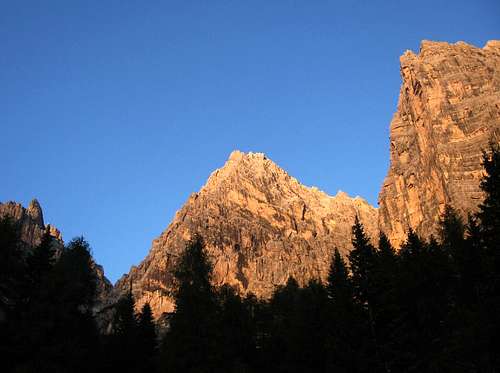
Sunset
Getting there
The group is located into the “Dolomiti di Zoldo” region. For who came from “Pianura Padana”, the fastest way is reach the village of "Longarone". Not far from the city of "Belluno".
The Sasso di Bosconero is placed in the middle of the group. It overhangs the valleys "Bosconero" and "Campestrin". The first one is reachable from the village of "Zoldo". The second one is reachable from the village of "Ospitale di Cadore". Both places aren't far from "Longarone".

From Turin or Milan or Venice: motorway A4 - Mestre - motorway A27.
Otherwise, reach the village of "Zoldo". It isn't the easiest way but very panoramic. From "Feltre" or "Belluno": road n.203 – Agordo – Passo Duran – Zoldo.
By plane The nearest international airports are "Treviso", used for many low-cost flights, and "Venice" "Marco Polo".
By train The nearest railway station is Longarone; Belluno station can also be used as the DolomitiBus service leaves from there for Longarone/Pecol.
By bus Various buses of the DolomitiBus service leave from the Belluno bus station (opposite the railway station) and reach Val Zoldana in approx. 1hour.
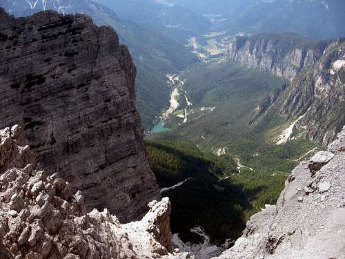
Bosconero valley
Main routes
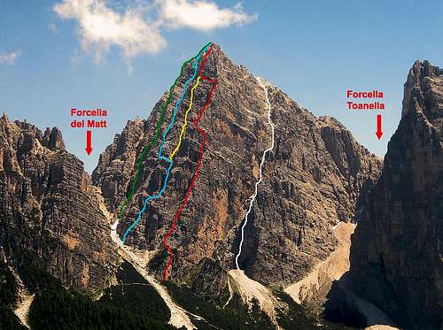
The routes on the NW side
White line: route n.2 Red line: route n.4 Blue line: route n.5 Yellow line: route n.3 Green line: route n.7
1. From southwest: (normal route) – From the refuge Bosconero across the forcella Toanella – 1000m – 3hours – I° F
2. From west: (the couloir) - G.Angelini/F.Vienna – 08/09/1928 – 650m – landslide area, better to avoid - I°/II°
3. Central spur: P.Sommavilla/R.Mosena - 12/08/1974 - 250m - III°/IV°
4. Northwest spur: (antispigolo nordovest) – L.Pretto/B.De Pellegrini – 11/07/1964 – 600m – fine and good rock - IV°/IV°+
5. From northwest: (via Angelini - Sperti) – Valentino Angelini/Silvio Sperti – 22/07/1924 – 600m – III°/IV°
6. From the north chimneys: U.Pomarici/G.Zennaro/P.Bellemo/A.Jovino – 03/07/1966 – good and clean rock – 550m – III°/IV°
7. From north: (via Pomarici-Costantini) – Ugo Pomarici/Regina Costantini – september 1967 – 550m – III°/IV°
8. North ridge: from forcella del Matt – G.Angelini/O.Tomassi – 19/08/1930 – 400m – II°
9. From east: (via Angelini) – G.C.A. Angelini – 15/07/1956 – lonely and wild environment – 600m – II°
10. From east: (via Pomarici-Trevisan-Freschi) – 30/06/1973 – II°
11. From ESE: from Val de l’Albero – G.Angelini/A.Rostagni – 15/08/1946 – 800m – II°
12. From southeast: from Val Larga – G.Angelini/G.Cercenà – 22/07/1943 – very long approach – 1970m – I°/II°
Red Tape
No fees no permits required
Camping and Huts
Camping is permitted in the whole Bosconero group and it doesn't require any red tape.

Casera di Bosconero 1457m
Open from: 20/06 - 20/09
Telephone: +39 0437 787346
Keeper: Monica Bagatin tel. +39 0437 787664
Property: CAI sez. Valzoldana tel. +39 0437 78100
Places: 28, winter hut 4
Access: From lake of Pontesei 858m, path 485, 2 hours E From Passo Cibiana, path 485, 2 hours EE

Casera Campestrin 1649m
Open from: permanenly
Telephone: none
Keeper: none
Property: CAI sez. San Donà di Piave
Places: 12
Access: From Passo Cibiana, path 483, 2 hours EE From Ospitale di Cadore, path 483, 3,30 hours E
Guidebooks
Guidebooks

"Pelmo e Dolomiti di Zoldo" - Guida dei Monti d'Italia - G.Angelini & P.Sommavilla - (the book wherefrom I've got the informations for this page) - 1983
"Il Bosconero" - Tamara edizioni montagna - De Zordo Vittorio
"La Val di Zoldo" - Cierre edizioni - Bonetti Paolo/Lazzarin Paolo - 2009
Other info
Tourist Office/Ufficio Turistico Provinciale di Zoldo Alto Viale Dolomiti, 4 32010 Zoldo Alto (BL) Tel. 0437 789145 Fax 0437 788878 www.infodolomiti.it zoldoalto@infodolomiti.it