
|
|
Mountain/Rock |
|---|---|
|
|
38.81180°N / 116.5884°W |
|
|
Nye |
|
|
Hiking |
|
|
Spring, Summer, Fall, Winter |
|
|
10888 ft / 3319 m |
|
|
Overview
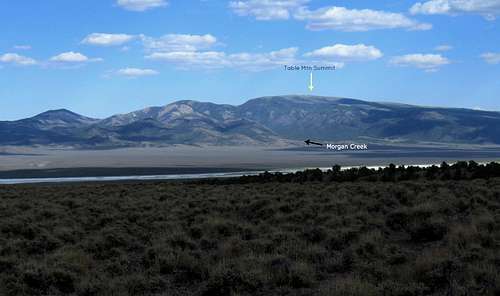
Table Mountain is a relatively isolated mountain in the center of the state of Nevada. Located in the Monitor range, it is a plateau like mountain with several ways to approach the summit. The access we used was the Morgan Creek approach and felt that this offered the best way to visit the area. Other approaches will be briefly discussed in the route section but again, most of the information provided on this page will refer to the Morgan Creek approach.Table Mountain is not technical in any way and is of interest to the group of climbers that are chasing the prominence peaks in the state of Nevada. With over 3600 feet of prominence, it comes in as the 35th most prominent peak on the top 100 list of Nevada's prominence peaks.
Getting There
From the north:To get to the trailhead (Morgan Creek) from US 50, leave the highway near a Nevada rest area (no toilet facilities) on the signed Monitor Valley gravel/dirt road (fairly high speed). The GPS waypoint for this junction is 39.4946 116.5224 Head south about 37-38 miles, passing the Monitor ranch along the way. Watch for an unsigned dirt road (waypoint 38.9919 116.6998) to the east and take it about 1.8 miles to a Y junction at 38.9749 116.6768
Take the right fork and head directly south over 6 miles to waypoint 38.8876 116.6846. Go left and east toward the Morgan Ranch about 1.7 miles but don't go into the ranch. Take the road (left) that heads uphill (waypoint 38.8720 116.6618) and drive 3 miles to the end of the road, passing the forest service boundary early on and then some camping spots on the right side of the road as you get near the end of the road. 4WD is not needed to this point. At a small clearing with an old FS bulletin board, the road splits with the jeep track you want going off to the right (see pic). This is where you need to find a spot to camp or park if you don't have high clearance and start your hike from. Those with high clearance and 4WD could drive a bit further, about 1/2 mile before hitting the wilderness boundary. Roughly, it is about 50 miles from US 50 to the end of the road.
From the south: As described in Bruce Grubb's book, Hiking Nevada, this information is provided:
From Tonopah, drive east 6 miles on US 6 and then turn north on Highway 376 for 13 miles. Turn right on the Monitor Valley road which is paved until the ghost town of Belmont. Beyond Belmont, the road becomes gravel/dirt. Watch for a turnoff for the Morgan Creek-Mosquito Creek road (easy to miss the sign since it is set back from the junction. Continue 5.7 miles, passing a turn off for the Mosquito Creek road along the way. Watch for the Morgan Creek ranch and avoid driving into their property. The Morgan Creek road is just past their property and is found at waypoint 38.8720 116.6618. It is another 3 miles to the end of the road as mentioned in the north route above. According to Bruce Grubb, it is 14.7 miles from the Monitor Valley road turnoff to the end of the Morgan Creek road and this makes it about 70 miles from Tonopah. Consult his book for his information. He does mention that this is graded road from the turnoff but another peakbagger, Brad Boester mentions that there is a stream crossing 5.6 miles from the Monitor Valley junction which might stop a sedan from further progress. He went up via the Mosquito Creek approach but it might prove to be useful to those who want to get to the Morgan Creek road.
 Road end Road end |  Wilderness boundary Wilderness boundary |  Old road up Old road up |
Red Tape & Disclaimer
Table Mountain is located on Forest service land and is part of the Table Mountain Wilderness area and so the rules and regulations that pertain to both Wilderness areas and forest service lands would be in effect. Humboldt-Toiyabe National Forest
1200 Franklin Way
Sparks, NV 89431
(775) 331-6444
FAX: (775) 355-5399
Be sure to let someone know where you are going as there are no services and no cell service for most carriers. Carry extra food, water, full tank of gas, sturdy vehicle with good tires as you may not see anyone else after you leave pavement. You need to be self sufficient. Even better, team up with another vehicle so that you have a safety net in case of vehicle problems. I am sharing with you the information I gleaned from my visit and can in no way be responsible for anything that goes wrong. Do this hike at your own risk.
 Trail Trail | 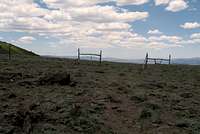 Gate Gate |  Route up Route up |
Camping
There are no organized campgrounds near this mountain and the nearest facilities for motels, gas and stores would be located in Tonopah. There is a bed and breakfast to be found in Belmont, a near ghost town that you pass through if you come from Tonopah.Camping is allowed near the end of the Morgan Creek road. It is primitive camping, no tables or outhouse facilities but several camp spots are very obvious. Water is available some of the year from Morgan Creek (filtering necessary) which runs close to the camping spots we noted.
Some areas of the forest land allow for dispersed camping. It is best to be self contained and follow the common sense "leave no trace" Here is what the forest service has noted on dispersed camping:
"Dispersed camping allows you to “get away from it all.” Peace, solitude and adventure are some of the advantages to choosing an undeveloped campsite. Since there are no facilities, you must bring your own water, camp at least 100 feet from all water sources and dig a hole at least six inches deep for disposal of human waste. Remember all Forest rules and regulations apply even in dispersed sites."
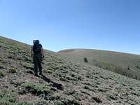 Ken hikes up Ken hikes up | 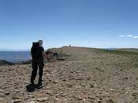 Ken reaches the summit Ken reaches the summit |  Witness benchmark Witness benchmark |
Weather
TonopahTonopah is the closest town that has a weather report resource. One recommendation is that if it is raining on the dirt roads beyond the pavement, change your plans and come back when the roads are dry.

Click for weather forecast

Click for weather forecast
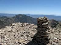
 Cairn Cairn | 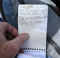 Register Register | 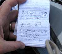 Register page Register page |
Route
From Morgan Creek TH:Round trip 8 miles
Elevation gain 3000
Trail for the first two miles then easy cross country for last two miles.
See Ken Jones peakbagger.com route page HERE
Other possibilities (
Mosquito Creek Trail:
See Brad Boester's trip report on peakbagger.com HERE
For more information on this I recommend the book "Hiking Nevada"
North Mosquito Creek Trail
Barley Creek Trail
Danville (east)
Richard Carey has put up a good page indicating the route he chose by highlighting it with a map and description.
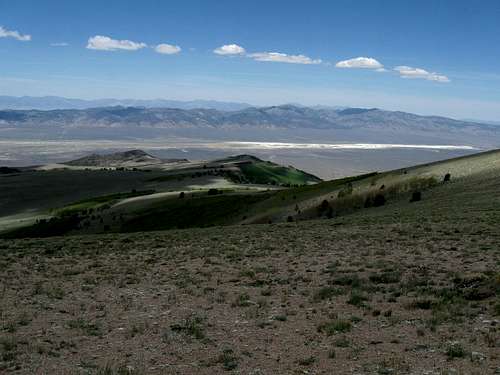
Summit views
 West West | 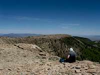 North North |  East East |
Down
Summit Register:
The register we found on Table Mountain was placed by Ted Brasket, who was aged 70 when he signed it in July 2000. Ted passed away in 2013 in Prescott Arizona (his hometown) at the age of 83. He climbed peaks all over the west but this was the first register that I had found that was placed by him personally with the exception of a small register of his that I found on the ridge between Mount Grafton and the Lincoln county highpoint in eastern Nevada. Normally, most registers I find in Nevada have been placed by Gordon MacLeod and Barbara Lilley who actually did climb this mountain in 1987 but whose register was missing. Peakbagger.com is a good resource for seeing who has been to the top of this one and you can see the peakbagger register at this LINK. As you can see from the peakbagger page, most ascents have been more recent but many of the climbers listed (and not listed) are from the Las Vegas Mountaineering club who has this mountain on their 50 peaks to do list.