
|
|
Mountain/Rock |
|---|---|
|
|
39.37670°N / 116.4621°W |
|
|
Eureka |
|
|
Hiking |
|
|
Spring, Summer, Fall |
|
|
10461 ft / 3189 m |
|
|
Overview
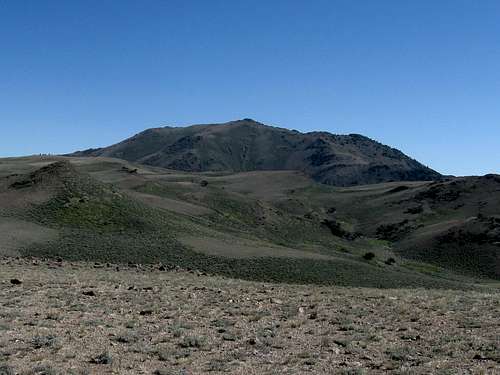
Summit Mountain
Summit Mountain is south off of Highway 50 between Eureka and Austin Nevada.
The attraction of this mountain is due to its 2701 feet of prominence, making it the 86th most prominent peak in the state of Nevada. In researching this mountain, I found very little information about it and can offer little on this page that would give insight into the history of the area.
It was interesting to find that the name of the mountain at one time may have been called BrokenBack. Did someone break their back on this mountain or did the geological survey people get to make up whimsical names if a mountain didn't have a name at the time they did their surveying? No, the benchmark was placed long before the movie came out.

Read the name
Located close to the geographic center of the state, there are several ways to get fairly close to this one. Each of the ways to access this mountain present problems and will require serious map study and evaluation of what route might work best for you. I'll share what we found out in the route section below.
Getting There
From I-80, leave Battle Mountain and head for Austin, 90 miles to the south. From Ely, take US 50 and head west to Eureka. From Las Vegas, go to Tonopah, get to highway 376 and drive north to the junction with US 50. A simple state road map works well for this.From either Austin (go east) or Eureka (go west) on US 50, drive about 35 miles to the signed Monitor Valley Road that will head south from the highway. It is signed as the Monitor Valley Road and will become a high quality dirt/gravel road when you turn onto it as you leave the pavement of US 50. (Waypoint: 39.4947 116.5222I)
If you are heading east from Austin, then the turnoff is just a mile or so before a minimum facility rest area (no bathroom) and if you are heading west from Eureka, it is just a mile or past that rest area. So if coming from Austin and you pass the rest area, turn around and go back because you missed it. After you turn south, drive about 13.5 miles on the very good dirt/gravel Monitor Valley road and watch for a sign indicating road 43004. This is near the actual geographic center of the state of Nevada. Turn left (east) on this road and follow it as it ascends for 7.7 miles to a jeep track road at the 7900 foot level. The waypoint for this key road is 39.3193 116.5195 This is the road I've described in the route section below as the jeep track road that will get you fairly close to the mountain if you have a 4WD high clearance vehicle with lo/lo capability to drive some of the gnarly parts of this road. An AWD vehicle like a Subaru should be parked at the first really steep section that requires the lo/lo gearing.
Another way, a second way is via Antelope Valley road (not my first choice):
As you drive west on US 50 from the town of Eureka, watch for the Antelope Valley road on the south side. It is between 16-17 miles from the junction of highway 278 and US 50. Drive south on Antelope Valley road, a well graded and good quality road. Take it about 16-17 miles and you will come to a turn off for a Ranch which is very well signed for "No Trespassing". Continue on past the ranch turnoff for about a mile (can't remember exact mileage) and watch for a small sign indicating road 004 (as shown in the Benchmark map book) and go west on it. This road isn't shown on the topo map I have but it is shown on the Benchmark map, page 58. After about 2 1/2 miles, watch for FS road 515 which cuts back to the right and follow it for about a 1/2 mile. The road is shown on Benchmark Maps as continuing quite a ways but it is washed out and it is time to park your vehicle and use this as the trailhead. A carefully driven sedan could probably make it to this point or close to it. This would be the beginning of the North Fork Allison Creek route. (Waypoint for the this area 39.3328 116.4140 Elev 7180) If you were to continue to the junction with the jeep track mentioned above, it would be about another 11 or 12 miles.

| 
| 
|
Red Tape
For more information:
Humboldt-Toiyabe National Forest
1200 Franklin Way
Sparks, NV 89431
(775) 331-6444
FAX: (775) 355-5399

| 
| 
|
Camping
No regular campgrounds are to be found in the area of this mountain but the Forest service allows for dispersed camping. It is best to be self contained and follow the common sense "leave no trace""Dispersed camping allows you to “get away from it all.” Peace, solitude and adventure are some of the advantages to choosing an undeveloped campsite. Since there are no facilities, you must bring your own water, camp at least 100 feet from all water sources and dig a hole at least six inches deep for disposal of human waste. Remember all forest service rules and regulations apply even in dispersed sites." Try and find spots where others have already camped. Pack out all garbage.

| 
| 
|
Weather

Click for weather forecast

Click for weather forecast

Click for weather forecast
Routes
Wallace Canyon (west side FS road 43004)The route we took:
Jeep track to Big Flatoff of 43004: See Ken Jones report on peakbagger.com Here is an excerpt from his report:
"I'd suggest coming at it from the west (Monitor Valley Road) side, which we went out. From the main Monitor Valley Road turn east onto USFS Road 004 (the signs in the valley precede the number with "43" so the junction may be signed "43004") and follow this passenger-car-drivable road to the 4WD road at about 7900'. Follow this road, if you and your vehicle are capable (meaning 4WD low range and the knowledge of how to use it effectively), to the vicinity of the large 9600' contour southwest of the peak. The road continues down to the 9209' saddle, but we were not confident that we'd be able to drive back up a steep stretch at about 9450' so we walked. The crux of the drive for us was between about 8600' and 9133'."
Adding to what Ken stated, the road was really nasty in some spots and had some steep grades that required extra low gear both going up and coming down. You are free to park and walk at any point you feel uncomfortable, the hike would have some ups and downs but that would be preferable to getting past your comfort zone and getting in trouble. Some of you who read this may laugh at my comments should you attempt this route but I'm not going to say I'm the most skilled 4WD driver and some parts of this drive I found a bit intimidating. I know Ken was holding his breath in a few spots.
Route map
Less attractive possibilities:
Pedlar Creek: Mentioned by John Vitz in a report as the way he accessed the mountain but he said it was a long hike from where a tree had blocked the road. Brad Boester also utilized this route and I have reproduced some of his report below:
"Take Hwy 50 East from Austin, proceed over Hickson summit then a few miles farther there is a sign marked "Belmont Rd" turn right here onto a well graded gravel road, (if you see a rest area on the left you went passed your turn off). Drive 3.7 miles to a cattle guard and a large sign marked "USDA Grimes Flat Seeding Area" turn left on a dirt road heading east along a fence. A car may be able to drive part way up this road with caution in dry conditions,(recommend 4WD if wet).Follow road for 3.5 miles to FR257 which is marked with a brown plastic sign and heads south. A 4wd vehicle can drive up this road but a tree was blocking the road at 7300ft. At about 7600ft or 4miles the road is overgrown and becomes more of a path that curves east,follow this path below and east of a rock outcrop(elev7800ft). To the east you will see the saddle(elev9400ft) between Antelope peak and the ridge to Summit mtn, proceed through juniper and sagebrush to this saddle or sidehill up the ridge to your right. The terrain becomes open with minor 2nd class rock near the summit." He lists his effort as 23 miles and 4300+ elevation gain.
No. Fork Allison Creek:
About 11 miles round trip and close to 3500' of elevation gain. Where the washout stops further progress with a jeep size vehicle, the hike begins. A mountain bike might be a good way to utilize a lot of the road that still remains beyond the washout. Hike up the road till you get to the saddle at 9200' (39.3717 116.4713). Go just beyond the fenceline and then start up the road remnant and pick your route up to the summit. Ken Jones had this to say about choosing this route in retrospect (from his peakbagger trip report)
"If you don't have the ability or vehicle to drive our 4WD road, I'd suggest walking the old road up the North Fork of Allison Creek. If you are approaching from the east, be aware that the road you would think is FR 004 is posted as ranch access only. Continue a little farther south on Antelope Road and you'll find the newly routed 004 which passes just south of the ranch's fence line. When it reaches a "T" you'll go right to access the North Fork."
We car camped at the end of the FS 515 road and checked out the washout in the morning. A stream had been running down the roadbed and had washed out a section where driving a vehicle would be a scary situation (meaning your vehicle could easily fall off the road and become a difficult retrieval situation). Perhaps an ATV could make it but not a Tacoma sized pickup.
Summit log
The register atop Summit Mountain was in bad shape. Water leakage had damaged it and that was too bad since we found entries dating back 40 or so years. Many of the pages couldn't be opened but in looking at the summit logs posted at peakbagger and lists of john, we got a good idea of who had been up there besides Ken and I. At the present, 6 others have reached the summit since we were there. 
| 
| 
|