
-
 7005 Hits
-
 89.01% Score
-
 28 Votes
|
|
Mountain/Rock |
|---|---|
|
|
46.41880°N / 11.84090°E |
|
|
Hiking, Scrambling |
|
|
Summer, Fall |
|
|
10033 ft / 3058 m |
|
|
Overview
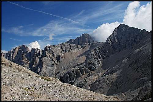
Marmolada and Sasso Vernale from passo delle Cirelle


South of the mighty, all dominating Marmolada, a long range of mountains stretches in the west-east direction. Who is ever ascending Cima del Uomo, 3010 m (even if it rises just above the very frequented Passo di San Pellegrino), or Sasso di Valfredda, 3009 m, or other summits, missing only a little the magical altitude of 3000 meters? That long ridge is connected with Marmolada with another, shorter ridge, going roughly in the south-north direction. On the northern part of it, just opposite of the huge south wall of Marmolada, Cime d'Ombretta are rising (2998 m, 2983 m, 3011 m), on the southern part of it, there is the highest summit of all mountains of the Southern Marmolada group - Sasso Vernale, 3058 m.
Sasso Vernale should not be confused with another mountain of a similar name - Gran Vernel, 3210 m. The latter is a hard reachable pyramid west of Marmolada.
One should also distinguish between the toponymes of Ombretta and Ombrettola. Between Marmolada and Cime d'Ombretta (or Cima Ombretta, 3011 m) there is Passo Ombretta, 2702 m. But south of Sasso Vernale there is Cima Ombrettola, 2931 m, and between the two mountains there is Passo Ombrettola, 2864 m. This saddle is important for our purposes, because from it the easiest ascent on Sasso Vernale goes.
Due to the wild surroundings, Sasso Vernale is an attractive goal for experienced hikers. The ascent scramble from the Ombrettola saddle is not hard, but it is also far from being easy. It requires constant attention, because due to exposure and steep slopes no mistake is allowed. An absolute safe step and clear head are needed, as on the ridge slabs there is a lot of rubble. In my old guidebook, the summit ascent is characterised as an "Eiertanz" - a "dance on eggs", and that is not far from the truth. During the World War I there was a path on top, but it has been already completely decayed and since then the slope has almost turned into the original, natural status. Those few iron poles are of no help, because they are placed wrongly, being intended to hold wooden desks, which are gone now. That is why today only rarely anyone goes on top of Sasso Vernale. Many visitors ascend Passo Ombrettola though, but they mostly do the hikes from one mountain hut to another, from one valley into another.
For those who seek for harder climbs, Sasso Vernale is also not a valuable goal. Its walls are not high and the mountain is too crumbly.
World War I

WW1 remains below Passo Ombrettola

Paths...
The area of Marmolada was during the World War I just on the frontline. During the ascent on Sasso Vernale the remains of military objects can be seen everywhere. In a scree basin you will see a whole deposit of decaying cans, in the valley SW of Passo Ombrettola wooden logs are lying everywhere, in the summit ridge of Sasso Vernale there are many caverns. The ridge was heavilly fortified and a military path also continued along the ridge towards Cima Ombretta. But, as said, all that is gone now and the ridge, connecting the two summits is nowadays as hardly passable as before the WW1. But many of the paths, leading across the high saddles were also beaten during the war time and they are the only benefit from those times.
Summit Views
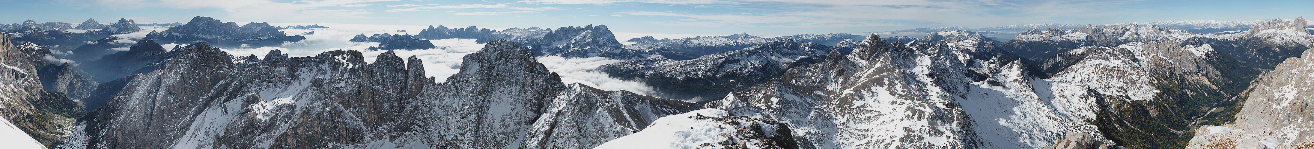 Click to run this one online |

Marmolada

Formenton and Sasso di Valfredda
The view from the summit of Sasso Vernale is fantastic. On the north, the most impressive feature is the huge wall of Marmolada. It can of course better be seen from the neighbouring Cima Ombretta, but also from Sasso Vernale it looks great. On all other sides the views are opened and so many mountains also in the distance can be seen. On the east the giants of Zoldano Dolomites are rising (Monte Pelmo, Civetta), from behind them one can distinguish the pyramid of Antelao. More towards the south-east there is the Schiara group and on the southern horizon the Pale di San Martino. The nearby ridge of Southern Marmolada chain was already mentioned. On the west you can recognise all the high summits of the Western Dolomites: Rosengarten/Catinaccio Group, Langkofel/Sassolungo and Sella Group.
Getting There
On Pian di Fociade

An old wisdom...
There are three very distinct and good approaches to Sasso Vernale. In all of them you can use mountain huts to break the long and enduring ascents into two days. But actually, only on the southern ascent you can reach a reasonably high altitude also by car.
1. On the north-west there is the famous Val de Contrin. The road through it is closed for public traffic, so you have to leave your car near Alba on some 1500 m. In the valley end there is Rifugio Contrin, 2016 m. Till there you will walk good 1 h 30 min.
2. On the north-east the trailhead is on Malga Ciapela, 1435 m. You reach it by the famous Marmolada road, deterring left in Caprile and then driving towards Passo di Fedaia (and Fedaia lake). From Malga Ciapela you walk by the mountain road towards the west and then ascend one valley step higher into Valle Ombretta. That is one of the most beautiful places in Dolomites. You are just below the mighty southern wall of Marmolada. At the valley end there is Rifugio O. Falier, 2074 m. For these 640 m of altitude you need 2 hours of walk.
3. The third starting point is on the south-southwest. That is Passo di San Pellegrino, 1907 m (connecting Moena on the west with cencenighe on the east). Actually, the real tour begins at Rifugio Fociade, 1982 m. But also the two mountain roads to this hut are closed for public traffic. The direct road from Passo di San Pellegrino is closed near the small lake of Pozze (for parking you pay 4 EUR), the other road deters uphill lower, on the eastern side of the saddle, but brings you closer to the Fociade alpine meadow. And the parking place on 1849 m is free of charge.
Routes Overview
 All routes on Sasso Vernale join on Passo Ombrettola  The summit scramble 1. From Rif. Contrin, 2016 m. From the hut you take the path No. 607, which goes towards the SE and targets Passo delle Cirelle. Soon above the hut it branches. We continue towards the SE till the passage around the place where the W ridge of Sasso Vernale comes down on the scree fields. On some 2475 m there is a crossroads. The path No 607 continues towards the SW on Passo delle Cirelle, but we must continue in the SE direction towards Passo Ombrettola. The path is marked as No. 612b. Soon from the left the path from Cima Ombretta comes, also there we continue towards the SE and in less than 3 h we reach Passo Ombrettola, 2864 m. From there, by the S-SW ridge of Sasso Vernale on top (45 more minutes). The hike till Passo Ombrettola is mostly easy, the summit ascent (still a hike-up) is difficult. From the hut 3 h 30 min, from the parking place good 5 h. 2. From Rif. O. Falier, 2074 m. From the hut you take the path No. 612 towards the SW. It first passes the strong eastern ridge of Cima Ombretta. Then it continues ascending through the Vallon d'Ombrettola, always in the same direction. In many switchbacks it ascends over the scree fields and finally reaches Passo Ombrettola, 2864 m. Then by the S-SW ridge of Sasso Vernale on top (45 more minutes). Again, the hike till Passo Ombrettola is mostly easy, the summit ascent is difficult. From the hut 3 h 30 min, from the parking place some 5 h 30 min. |
3. From Rifugio Fociade, 1982 m. From the hut you continue by the marked path No. 607 towards the N. Over two valley steps you reach the high Val de Tas Cia. In the rubble valley on some 2400 m the path branches. You turn right and over the screes tediously ascend Passo delle Cirelle, 2683 m. 2 h till here. From the saddle you take the path No. 612 (the right one), which goes towards the E-NE across the slopes. Inscriptions guide you to Rif. O. Falier, but first the path must go on Passo Ombrettola. On two places we lose a few meters of altitude, then the path resumes ascending and in less than 1 h we reach Passo Ombrettola. Then by the S-SW ridge of Sasso Vernale on top (45 more minutes). Again, the hike till Passo Ombrettola is mostly easy, the summit ascent is difficult. From the hut 3 h 30 min, from the parking place some 4 h.
4. From Passo Ombretta, 2702 m. This important pass connects Val de Contrin and Valle Ombretta. From the path the marked path No. 650 ascends the summit of Cima Ombretta, 3011 m. From there it descends towards the SW, thus enabling a round tour from Rif. Contrin. But from the summit of Cima Ombretta, we can continue by the connection ridge also on Sasso Vernale. The remains of military paths are completely destroyed, so the ridge is a difficult scramble, on a few places also quite exposed. Supposedly some easy climbing details up to UIAA II are also required.
Red Tape
No limitations. All mountain roads towards the huts are closed for public traffic.
Huts And Camping
See the main page of Marmolada Group to get some more information about mountain huts and weather links for the area. The three supporting huts were mentioned above. Above Passo Ombretta (be careful: not Passo Ombrettola!) there is also a bivouac (on 2702 m), but it is of no use for ascent on Sasso Vernale, unless we do the ascent over the connecting ridge from Cima Ombretta.
In the main valleys and on Passo di San Pellegrino, close to the trailheads, there are many hotels. On Malga Ciapela there is also a camping place.
When To Climb?
The best months are in high summer and autumn, until the first snow. The path from Passo delle Cirelle to Passo Ombrettola crosses the northern slopes of the main ridge, so in early summer some snow rests can be expected. An ascent in winter conditions would require a full winter equipment. The summit ridge is very steep and exposed, so if under snow (or even iced) it requires a proper belaying. Skiing would be possible all the way down from Passo Ombrettola.