
|
|
Mountain/Rock |
|---|---|
|
|
47.96342°N / 121.46417°W |
|
|
Snohomish |
|
|
5819 ft / 1774 m |
|
|
Overview
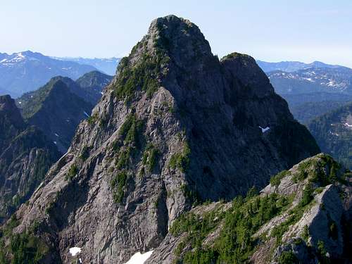
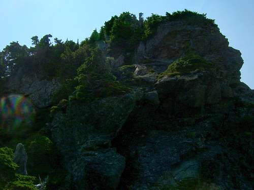
Sheep Gap Mountain looks imposing from this view, but it is not as bad as it looks. It consists mostly of steep, class 3/4 rock and brush, with only one short pitch (in center of photo) that should have a rope belay.
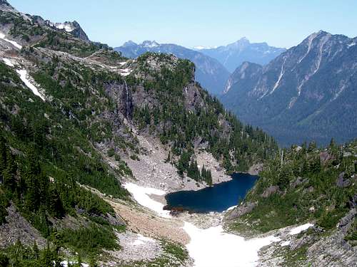
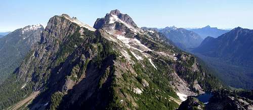
Weden Lake from Weden Pass
All climbs of Sheep Gap Mountain should start from Barlow Pass. To find Barlow Pass, simply follow the Mountain Loop Highway east from Granite Falls (30.5) miles until the pavement ends. Park here, and follow the gated road leading towards Monte Cristo for about one mile. A mountain bike will save you about ten minutes each way if you are so equipped. Now hike the Weden Creek/Gothic Basin Trail #724 for approximately four miles to Gothic Basin. The trail will start out flat and well graded, but will turn into a steep, rocky scramble by the end. For some reason, the trail is not marked on USGS maps, but you will enter the basin at the following coordinates: (N47 58.820 W121 27.590 Elev. 4950').
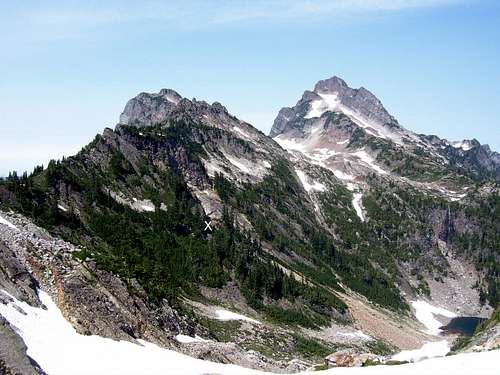
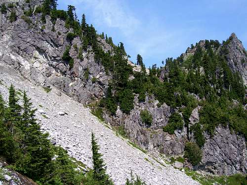
Continue west into the basin until on the west side of two small lakes (these lakes can be seen on the USGS map 0.25 miles SE of Foggy Lake). From this point, begin traversing the ridge south at approximately 5100'. It is likely that you will encounter at least some snow on the way to Sheep Gap Mountain, so an ice axe would be a good idea. It is easiest to stay high on this traverse, but at one point it will be necessary to drop down to about 4900' to get around a cliff band (marked with an "x" in the photo below). Your objective is Weden Pass, which is the 5100' pass on the east side of Sheep Gap Mountain's north summit (Pt. 5683). Do not confuse Weden Pass with the 5100' pass on the north side of Pt. 5683.
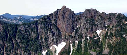
Gothic Peak, Gothic Basin, Del Campo, and Weden Lake from Weden Pass
Note: For those who just want some good views, but don't want the hassle of climbing Sheep Gap Mountain's main summit, a quick class 2/3 scramble west from Weden Pass will put you on top of Sheep Gap's north summit.
From Weden Pass, traverse SW towards the notch on the north side of Sheep Gap's main summit. It will be necessary to drop down to about 4900' on this traverse. The best place to drop down is on a brushy dirt ramp (top is located at N47 58.048 W121 27.510 Elev. 5000') that will allow you to avoid a cliff band coming off the north summit.
Looking back at the 'dirt ramp' on the traverse to Sheep Gap's main summit
As you traverse, a mine shaft located at (N47 57.974 W121 27.666 Elev. 4900') will be an interesting diversion.
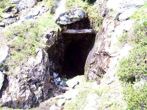
Mine shaft on Sheep Gap Mountain
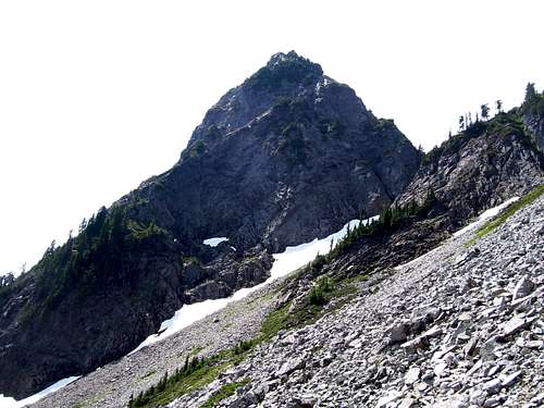
Sheep Gap Mountain's main summit on the traverse from Weden Pass
As you approach the notch at 5250', you will begin to notice that Sheep Gap Mountain is not nearly as scary looking close up as it is from a distance. Cross through the notch, then begin climbing up the steep, brushy north arete. There was only one short section (50'-60') of class 4 where we elected to rope up. We protected this section with only three slings, and no special rock climbing gear was necessary.
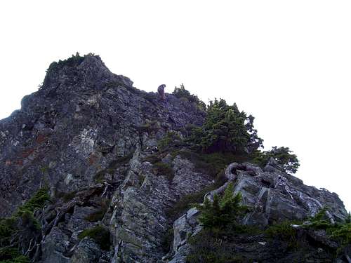
Rappel of the Class 4 section on Sheep Gap
The only thing I wished I had brought, and would have given my left arm for, was a small pruning saw. No need to denude the side of the mountain, mind you, but there were definitely a few annoying branches that were in the wrong place at the wrong time.
Upper section of Sheep Gap Mountain climb
The route to the summit is self-explainatory, just make sure you come down exactly the same way you came up. A few pieces of temporary flagging might be nice to ensure that you don't wander left or right. Rappel the one pitch you roped up for, using the same tree as everyone else. Don't reuse the existing webbing, as it is sure to be many years old. We used one 150' rope for the climb and rappel, but anything over 100' would be adequate.
Request: Would the next person to climb Sheep Gap Mountain (2016 perhaps?) please bring one or two pencils for the summit register? The register itself is waterproof paper, and is in fine shape. The pencil, however, was destroyed, and only a tiny piece of it remains. Also, please make sure to place the register back upside down to prevent water leaking in - Thanks.
Here are a few views from the top (bottom two are from north summit).
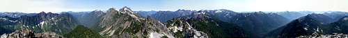
Sheep Gap Mountain pano
Gothic and Del Campo from Sheep Gap's north summit
Getting There
Follow the Mountain Loop Highway east from Granite Falls for 30.5 miles to Barlow Pass. Then follow the gated Monte Cristo Road one mile to Trail #724. Follow this trail about four miles to Gothic Basin.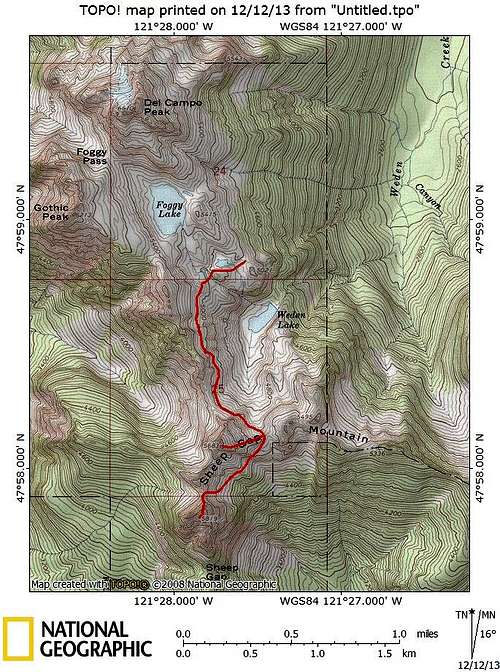
Sheep Gap Mountain route map. I have not attempted to draw in the Gothic Basin trail. I have also not drawn in the path to Weden Lake, as I have never been on it, or know where it originates.