
-
 16675 Hits
-
 79.04% Score
-
 10 Votes
|
|
Mountain/Rock |
|---|---|
|
|
45.12732°N / 109.61712°W |
|
|
Hiking, Mountaineering, Scrambling |
|
|
Spring, Summer, Fall, Winter |
|
|
12351 ft / 3765 m |
|
|
Overview
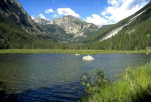
Bowback Mountain is one of the 26 ranked Montana 12,000 foot peaks topping out with 731 feet of prominence. Located about 2.5 miles north of Castle Mountain puts it right at the heart of a large group of 12ers surrounding the West Fork Rock Creek. Bowback has two distinct summits separated only by a few hundred yards. The slightly lower north summit is easily reached by a long walk over talus and plateau walking but the ture summit, just to the south requires a small traverse on slightly more exposed, looser terrain. Overall, the summit of Bowback can be reached with not much more than some off trail hiking and a small amount of class 2+ scampering. The views from the summit are very rewarding.
Bowback Mountain may be named for the very uniform bowlike shape the ridge makes between the false and true summits when viewed from the east. There are two main approach options, both of which are pretty long as the mountain lies within the 944,000 acre Absaroka Beartooth Wilderness. It is possible that the east face can offer some technical routes but from my experience, much of the rock in this part of the Beartooth Mountains was more broken and of lower quality then the rock seen on the Bears Tooth for example.
 Bowback Mountain Bowback Mountain |  Bowback from Silver Run Bowback from Silver Run |  Bowback and Sundance Bowback and Sundance |
Approach 1
The standard way to approach Bowback Mountain starts from the West Fork Trailhead near Red Lodge Montana. This is one of the more popular trailheads in the Beartooth Mountains and offers fantastic scenery. From the center of Red Lodge at the MT 308 and US 212 junction, head west 0.3 miles on US 212 and turn right onto the West Fork Road with signs for the Red Lodge ski area and measure distances from this turnoff. The road immediately comes to a Y, stay left and head up the paved road passing the Palisades Campground Road (gravel) on the right after 1.1 miles. Continue and enter the Custer National Forest after 2.8 miles and turn left to stay on the West Fork Road at 2.9 miles. Taking a right at this turnoff takes you to the ski area. Pass the winter closure gate at 5.2 miles, the Basin Lake Campground at 7.2 miles and the road turns to gravel at 7.4 miles. At mile 10.5, pass the Cascade Campground and reach the trailhead at mile 13 with an elevation of 7,890 feet. Here there is room for about 40 cars and 7 horse trailers and a pit toilet is available.Variant 1
From the West Fork Rock Creek trailhead, start up the trail and take an immediate left with a sign for Quinnebaugh Meadows and Sundance Lake. Follow this trail for two miles through a burn area and reach the small Sentinel Falls at 8,400 feet just past a couple switchbacks. Continue up the more forested trail another 2.2 miles to Quinnebaugh Meadow and the junction with the Lake Mary Trail.
The meadow offers fantastic camping and the first views of Whitetail Peak. Continue straight and cross the stream draining Lake Mary on a series of small logs or rocks and reach the first culvert bridge 0.6 mile past the Lake Mary junction at 8,950 feet. At this bridge a short boot path heads up this side drainage towards Senal and Dude Lakes and this will be the start of the North Ridge route.
 Whitetail from Quinnebaugh Whitetail from Quinnebaugh |  Silver Run from West Fork trail Silver Run from West Fork trail |  Sundance from West Fork trail Sundance from West Fork trail |
Variant 2
The second variation of Approach 1 is used to climb the South Ridge route on Bowback Mountain. From the culvert bridge where the trail crosses the creek heading up towards Dude Lake for Variant 1, continue 1.2 miles up the trail to the second culvert bridge which crosses Kookoo Creek (draining Kookoo Lake).
 Whitetail near Kookoo Lake Whitetail near Kookoo Lake |  Whitetail from Triangle Lake Whitetail from Triangle Lake |  Silver Run from Kookoo Lake Silver Run from Kookoo Lake |
Approach 2
This approach is often regarded as a horrible hike from hell worthy of only two words..."stay right"Although I have not yet done it, I will describe it briefly here. Start at the East Rosebud Trailhead. From the MT 308 and US 212 juction at the south end of Red Lodge, head north on US Highway 212 for 1.5 miles and turn left onto MT State Highway 78. After 19.7 miles reach Roscoe and make a sharp left onto East Rosebud Road and measure from this point. After 0.2 mile, pass by the Grizzly Bar and restaurant and continue another 2.4 miles where the road turns to gravel. At mile 3.7, make a left onto the East Rosebud Lake Road and quickly cross East Rosebud Creek on a bridge. Just after the crossing, make a right on East Rosebud Lake Road and cross a cattle guard. At mile 8.3 enter the Custer National Forest where the road becomes paved again and now becomes FS Road 2177. Pass the Jimmy Joe Campground at mile 11.9 where it turns to dirt once again. Pass the Phantom Creek trailhead at mile 13.6 and continue another mile to the East Rosebud trailhead at 6,200 feet elevation with ample parking.
From the trailhead, hike the very nice trail to Rainbow Lake and consider your future. You will have to hike up Whirlpool Creek which drains into Rainbow Lake at its southwest edge. Getting to the mouth of Whirlpool Creek just may be the hardest part because you will likely have to ford East Rosebud Creek and bushwhack around the south side of the lake through thick forest and marsh. Once at the mouth, hike through bushes and stay on the RIGHT side of the creek on talus instead of the left side where the bushwhacking might be impossible. After a couple miles up Whirlpool Creek, turn left and climb up a side drainage towards Elephant Lake with very good camping. You can then reach the South Ridge route by continuing straight up the valley passing Lake Susanne and reaching the Bowback/Sundance saddle by a steep, loose talus slope that always melts our sooner than its corresponding east side. I'll add more detailed info when I actually do this approach as well as info for the West Ridge.
 East Rosebud Lake East Rosebud Lake |  Rainbow Lake Rainbow Lake | 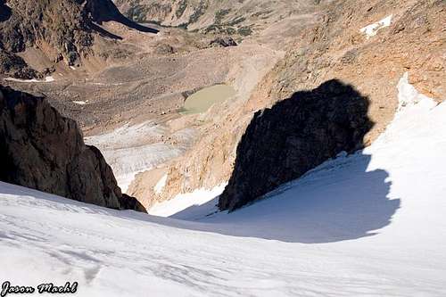 Sundance glacier Sundance glacier |
Route Options
North RidgeRatings: YDS – Class 2, Exposure – 2, Bushwhacking – 2
Time – 5 hours one way from Quinnebaugh Meadow
Using the 1st variation of Approach 1, locate a small boot path heading west up the valley towards Senal and Dude Lakes. Leave the main trail here and follow the faint path through the bushes between two streams for 0.1 mile. When the streams meet, cross onto the north side of Dude Creek and head sharply to the right, climbing above some smooth granite slabs. Reach a large talus field at 9,320 feet and climb it heading straight up the slope and slightly to the left. Aim for the large northeast facing snowfield directly to the southwest. Once at the top of the talus field after about 700 feet of climbing, you will reach a flat area at 9,920 feet. Turn left and hike east and descend about 100 feet, cross through some bush and reach the creek again right below the headwall leading up to Senal Lake at 9,820 feet. Do not climb up to Senal Lake. Cross the creek just below the waterfalls cascading down the headwall and hike 0.35 mile up the small valley just to the south of Senal and Dude Lakes to where the slope steepens. Depending on the season, this valley may be snow covered or a talus walk. Climb up the steepening snow slope (axe and crampons) for 1,000 feet to its end at 11,100 feet. The steepest part is at the top around 44 degrees. There may also be a cornice to navigate around at the top. From the top of the snowfield, continue west on talus for 0.5 mile above and to the north of a flat plateau and crest a small ridge at 11,780 feet. Cross over this ridge (which leads south to Point 11,867) and hike west for 0.7 mile to a broad saddle at 11,700 feet. Continue west, hike 350 feet up and contour south of the unranked Elk Mountain and descend 100 feet to a small saddle just north of Bowback Mountain. Hike south up the ridge for 300 feet to the 12,345 foot false summit and drop 60 feet to the saddle connecting it to the main summit (Class 2). Bypass the remaining difficulties of the ridge to the right (west) side and pass below the summit cliffs. Turn sharply left (east) and climb 100 feet up talus to the summit (Class 2). The traverse between the false and true summits is 0.15 mile.
RT Distance:
From Camp at Quinnebaugh Meadow – 10 miles
From trailhead – 18.4 miles
With descent of South Ridge Route – 10.2 miles
RT Elevation Gain:
From Camp at Quinnebaugh Meadow – 4,420 feet
From trailhead – 5,500 feet
With descent of South Ridge Route – 4,420 feet
 Climb this snowfield Climb this snowfield |  The gentle N Ridge The gentle N Ridge |
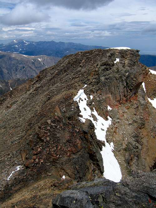
Traverse from the false to true summit
South Ridge
Ratings: YDS – Class 3, Exposure – 3, Bushwhacking – 3
Time: 6.5 hours one way from Quinnebaugh Meadow
Just before crossing the second culvert bridge, leave the trail and begin bushwhacking steeply on the north side of Kookoo Creek for 1,000 feet over 1 mile to where the slope relents and opens to talus. A short ways from the main trail, locate a corridor of grass that offers a good way through the trees. You may see a few cairns here. Following this corridor will make for less bushwhacking but it heads straight up the steep slope. When the corridor ends, find the easiest way through bushes and trees until reaching talus. When the slope eases, hike on easy talus in or right along the creek for 0.2 mile to Kookoo Lake 10,250 feet. Hike around the south side of the lake and climb west 0.4 mile to the north end of Triangle Lake at 10,400 feet and walk around its north side. Cross the stream between Triangle Lake and a long skinny lake just to the northwest. Climb to the ridge that separates Ship Lake and Bowback Lake and follow it on its crest or just to the south of the crest on grass, then talus to 11,000 feet. The hike through this basin is gorgeous. Your goal is to reach the 11,700 foot low saddle between Sundance and Bowback Mountains, located 0.7 mile west of Triangle Lake. The east facing slope leading to the saddle often has snow through mid-August so carry crampons and axes.
Climb 700 feet up moderate snow to the saddle. The angle of this slope reaches 40 degrees at the top. Avoid the cornice at the top on rock to the left (south) side. From the 11,700 foot saddle, turn north onto the ridge and hike up on loose talus to the route’s crux at a 15 foot cliff band (Class 2). Climb the cliff band by heading to the right (east) side of the crest and climbing a broken part of the cliff with good footholds (Class 3). Once up the crux, continue on easier terrain for 0.2 mile to a rib heading down to the west. Cross the rib and 12,150 feet and traverse on the ridges’ left (west) side across ledges and gullies. You will gain about 100 feet on this traverse. If the difficulty ever exceeds Class 2, backtrack and locate an easier route. Reach a notch where a small saddle can be seen just below you and locate a narrow chimney. Down-climb this chimney about 25 feet (Class 3) and pass on the right (west) side of some large boulders at its base before getting to the small saddle. Continue on the west side of the crest and cross a narrow ledge and climbing 50 feet up a loose gully to reach the summit plateau of Bowback Mountain (Class 2+). Walk north 0.1 mile over flat terrain to the high point at 12,351 feet.
RT Distance:
From Camp at Quinnebaugh Meadow – 11.6 miles
From trailhead – 20 miles
RT Elevation Gain:
From Camp at Quinnebaugh Meadow – 3,500 feet
From trailhead – 4,500 feet
| Silver Run from Kookoo Lake |  Route to Bowback/Sundance saddle Route to Bowback/Sundance saddle |  Looking up south ridge Looking up south ridge |
Bowback/Sundance Traverse
Ratings: YDS – Class 3, Exposure – 3, Bushwhacking – 0
Time: 2.5 hours one way
This is a fun way to combine both Bowback and Sundance Mountains. It is a very long day no matter where you start. The traverse can be done in either direction however if the key gully is snow filled it may be better north to south. One possible but very long way would be to camp at Quinnebaugh Meadow and hike 3.8 miles to Shadow Lake, climb the northeast slopes route on Sundance and traverse to Bowback while descending the north ridge. It would be a challenge to bring heavy packs up to Kookoo Lake so starting here probably wouldn’t be feasible, unless you go ultra-light. I'll describe the route from south to north.
From the summit of Sundance Mountain, walk the easy summit plateau for 0.3 mile west as it narrows and begins a broad turn to the right (north). Along this curve, bypass below some towers on the left (south) side of the narrow ridge (Class 2). The terrain eases again and becomes a very wide open plateau. Continue north, then northeast on staying as close as possible to the steeper slopes to the east leading down to Marker and Ship Lakes. Contour just east of Point 12,030 and reach the end of easy terrain at the top of a northeast facing loose gully (may be snow filled with 40 degree snow well into July). Finding this gully is the key to attaining the 11,700 foot saddle. Descend this gully for 200 feet, exit it to the left and traverse across the base of some cliffs on their west side and hit a notch. From this notch, the saddle can be seen. Descend 100 feet on easy talus to the saddle and continue on the south ridge route of Bowback Mountain route.
One Way Distance - 2 miles
View of the traverse to Bowback Mountain from Sundance Mountain
West Ridge
YDS - Class 2
RT Distance from East Rosebud TH - 12.5 miles
This route is best done in conjunction with Mount Inabnit. Approach via Snow Lakes which is done by hiking up the East Rosebud Creek Trail from the East Rosebud Trailhead. It heads above some cabins along East Rosebud Lake and after 2.5 miles on the trail at an elevation of 6,670 feet, leave the trail and head left (SE) through the burn area aiming for the valley coming down from the north. Be sure to leave the trail about a tenth of a mile before it crosses Snow Creek. Make your way up through a barrage of dead logs, talus and bushes for 0.4 mile to 7,100 feet where the slope steepens. Begin heading straight up the steeper slope which is exposed to the heat of the sun until you reach a small ridge above Snow Creek overlooking a 100 foot waterfall at 7,640 feet. Continue up this ridge towards the base of a large cliff and cut right and begin an ascending traverse around 8,000 feet. Traverse up through sparse trees and a lot of talus southward and above Snow Creek. Reach the creek side around 8,300 feet which is 3/4 mile from where you left the trail and follow it a short ways. Then ascend left above the creek and around the forest to avoid bush whacking. At 9,000 feet enter a small drainage and hike up meadows for 100 feet or so, then when you see Lower Snow Lake to your right, continue around it on its east side and about 50 feet above. Cross a small stream coming from the east at 9,200 feet and continue through open trees a short ways to the Upper Lake. Descend to it and walk on grass around its east side to the inlet stream which is 3 miles from where you left the trail. The area around Snow Lakes offers a bunch of great camp spots.
From the inlet stream at Upper Snow Lake (Elev. 9,275 feet), do not cross it but instead follow along its south side up a short steep section through trees to 9,500 where the terrain mellows considerably. Hike 0.4 mile east over flat terrain through sparse trees and meadows to a side stream at 9,600 feet which you can easily cross. Continue through beautiful meadows along the left side of Snow Creek and avoid any willows by following inside the heavily braided creek which allows easy walking on rocks. At 9,860 feet, the terrain becomes flat; continue a short ways now on the creeks' right side to the high tarn at 9,925 feet which is 1 mile from Upper Snow Lake. This tarn has some of the best camping around! Go around the west side of this small tarn and reach the end of the meadows at 10,000 feet where you begin climbing talus. At 10,200 feet reach the base of the permement snowfield and climb easy snow to 10,900 feet staying on the left side. Here the slope gradually steepens to about 40 degrees. Pass to the left of a small crack at 11,000 feet (easily solod), and continue to the Bowback/Inabnit saddle at 11,475 feet. The top of the snowfield may have a cornice and or some ice to work around to either side of on some loose Class 2-3 rock. From the saddle you now have a commanding view of some of the most remote areas in the Beartooth Mountains. Castle Rock Spire, Snowbank Mountain and Point 12,090, including the "Gone Again Couloir" can be seen. The green colored lake down below the saddle to the south is Lake Susanne.
From the 11,475 foot saddle, ascend the west ridge of Bowback Mountain which is a simple Class 2 talus hike. The west ridge takes you to the 12,345 foot false summit of Bowback Mountain at which point you drop 60 feet to the saddle connecting it to the main summit (Class 2). Bypass the remaining difficulties of the ridge to the right (west) side and pass below the summit cliffs. Turn sharply left (east) and climb 100 feet up talus to the summit (Class 2). The traverse between the false and true summits is 0.15 mile.
Map
Note the Snow Lakes approach for the west ridge is not shown on the map below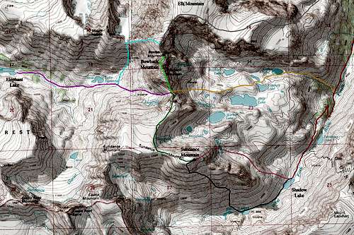
RED: West Fork Rock Creek Trail
GREY: Approach 1; Variant 1 up Dude Creek and up the North Ridge of Bowback
ORANGE: Approach 1; Variant 2 up Kookoo Creek
LIGHT GREEN: South Ridge route on Bowback Mountain
BRIGHT PINK: Approach 2; East Rosebud Creek/Whirlpool Creek
LIGHT BLUE: West Ridge route on Bowback Mountain - Class 2
DARK BLUE: South Slopes route on Sundance Mountain - Class 3
MAGENTA: Northeast Slopes route on Sundance Mountain - Class 2; Moderate Snow
DARK GREEN: West Ridge route on Sundance Mountain - Class 3
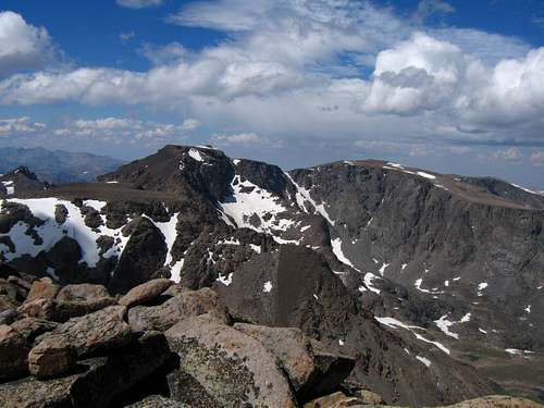
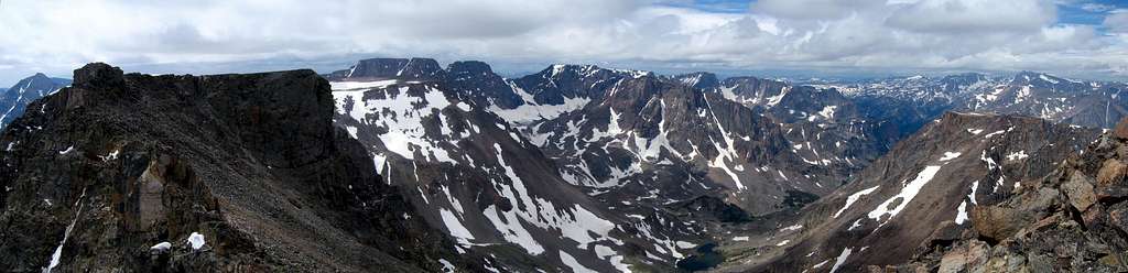
Summit View
Camping/Red Tape
There is great camping at the Quinnebaugh Meadows right around the Lake Mary trail junction. Another nice place would be Elephant Lake on the second approach option. Camping is also available at many places along the West Fork Road. This area is within the Abasorka-Beartooth Wilderness therefore no motorized travel, including but not limited to, cars, motorcycles, bicycles, hang gliders, airplanes, scooters, etc... is allowed.Please practice leave no trace practices and do not disturb wildlife. You are in grizzly bear country here so always carry bear spray, or a gun, or both for protection only if you are attacked. Report any bears you may have killed or injured to a ranger as a result of any defenses you may have taken. There is a ranger office right at the junction of US Highway 212 and the West Fork Road at the southern end of Red Lodge.