
-
 17228 Hits
-
 81.84% Score
-
 14 Votes
|
|
Mountain/Rock |
|---|---|
|
|
45.09800°N / 109.65368°W |
|
|
Hiking, Mountaineering, Scrambling, Skiing |
|
|
Spring, Summer, Fall, Winter |
|
|
12401 ft / 3780 m |
|
|
Overview
Castle Rock Mountain sits just to the west of Point 12,540 and to the east of Darlene Mountain. This east-west oriented ridge of 12,000 foot peaks is one of the highest areas in Montana. Castle ROck Mountain is a relatively easy peak to climb but it does require quite a bit of effort to get to as it's right in the middle of the 944,000 acre Abasorka-Beartooth Wilderness. It would make sense to add climbs of other nearby 12,000 foot peaks during a trip to the area. The namesake Castle Rock Glacier flanks the south slopes of the mountain however this glacier is rapidly receding and is not much more than a permanent snowfield now. A new, very large lake has formed on the SE end of the glacier at 11,000 feet as a result of this. For a climb of multiple peaks in the area, it is best to approach from the south from either the Beartooth Lake or Clay Butte trailheads. One can also approach from the west via the West Fork Rock Creek Trail or the north from Whirlpool Creek but for the scope of this page I'll describe two south side approaches.
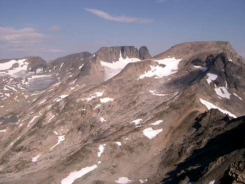
Castle Rock Group
Darlene Mountain sits just west of Castle Rock Mountain an easy rock hop away. At 12,250, Darlene isn't quite as high as Castle Rock Mountain but it is still ranked with 390 feet of clean prominence.
Getting There
There are two trailheads at the south you can use to approach this peak, both are long. You can either start at the Clay Butte trailhead or the Beartooth Lake trailhead. Since the trail heading around the east side of Beartooth Lake is very marshy, the Clay Butte trailhead may be better, however you will have to start your hike with a 600 foot descent going this route so pick your poison. No matter which trailhead you choose, you need to get to Native Lake.Beartooth Lake Trailhead
From the MT 308/US 212 junction at the south end of Red Lodge, Montana head west on US 212 for 40.5 miles going over Beartooth Pass and turn right on the signed turnoff for Beartooth Lake and campground. Take this gravel road and stay straight after 0.3 miles and pass the boat launch. At 0.6 miles from the highway, turn left to the trailhead marked with a sign with room for no more than 10 cars.
Clay Butte Trailhead
From the Beartooth Lake turnoff, continue west on US Highway 212 for 1.5 miles towards Cooke City and turn right on the gravel Clay Butte Road. Drive this good road for 1.5 miles to the signed trailhead on the roads' left side right before a sharp switchback at 9,580 feet in elevation. If you start at the Clay Butte trailhead, start hiking the nice trail and reach a signed junction with the Granite Lake trail after 1.1 miles at 9,260 feet. Continue on the trail as it weaves up and down small hills and cross many tiny creeks along the west side of Beartooth Butte. After 1.9 miles from the Granite Lake junction where the stream descends a short ways to a larger creek at a little 3 foot waterfall, leave the trail, cross the creek and follow a cutoff boot path for 0.3 mile that meets the main Beartooth High Lakes trail at the southern end of Native Lake.
If you start at the Beartooth Lake trailhead, walk around the lakes' east and north sides through a large swamp (bring waders) OR above the swamp on many game trails in the trees to the east. Horrible bushwhacking, creek crossings and route-finding is insured if you do this. Take the swamp and deal with it. At 1 mile from the trailhead, the swamp ends and the trail climbs gently through beautiful meadows along the east side of Beartooth Butte for 1.9 miles to the signed junction with the Island Lake trail. Stay straight for another 0.7 miles to the north end of Beartooth Butte and a signed junction with the Clay Butte Trail. Stay right onto the Beartooth High Lakes trail and go 0.5 mile to the south end of Native Lake.
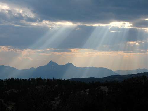
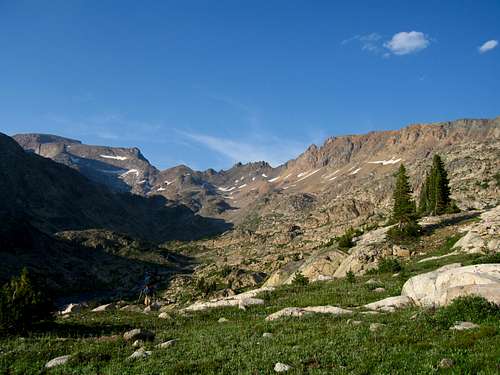
Sunbeams over Pilot Peak from the Clay Butte Trail
From Native Lake, stay on the trail as it contours around Surprise Lake, then descending 150 feet to a creek crossing and an unnamed lake at 9,320 feet, 2 miles from Native Lake. There is good camping here which is located only a few feet south of the Montana/Wyoming border. Do not follow an obvious trail heading steeply up the hill next to the meadow but instead hike around to the north side of this small lake and catch the main trail just out of view from the meadow. Contour around Thiel Lake and descend slightly to the creek draining Throop Lake at 9,400 feet.
Shortly after this crossing continue up steep switchbacks for 300 feet to a flat meadow at 9,750 feet where the slope eases. This part of the trail has substantial horse damage and is slick. Cross the Marmot Lake outlet stream (good camping and fishing) at 9,860 feet and cross over a small saddle just above Kidney Lake. Hike along the shore of Kidney Lake and make another 300 foot descent to Wright Lake. Great Camping can be found at Wright and Martin Lakes. Leave the trail here and walk north for 0.3 mile around the left (west) side of Martin Lake to its northwest corner. Continue up a small valley from here and climb to a small 10,040 saddle, with fantastic views of the Castle Group, 0.5 mile from the northwest corner of Martin Lake.
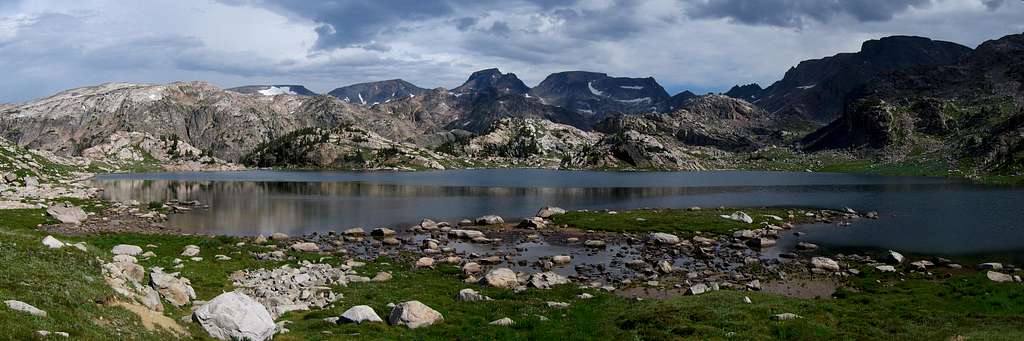
From this saddle, descend slightly passing a very small tarn and begin contouring right at 10,000 feet and up a prominent valley to the northeast towards Crystal Lake. Walk around the right (east) side of Crystal Lake on talus and grass to its north side at 9,900 feet with some of the best camping around, 0.8 miles from the small saddle. The approach is over (well...kind of). Continue north around the Pleiades Lakes and contour west around a small knob. Descend to the creek draining Flat Rock Lake and follow it to the lake, 1.2 miles from Crystal Lake.
From this saddle, descend slightly passing a very small tarn and begin contouring right at 10,000 feet and up a prominent valley to the northeast towards Crystal Lake. Walk around the right (east) side of Crystal Lake on talus and grass to its north side at 9,900 feet with some of the best camping around, 0.8 miles from the small saddle. The approach is over (well...kind of). Continue north around the Pleiades Lakes and contour west around a small knob. Descend to the creek draining Flat Rock Lake and follow it to the lake, 1.2 miles from Crystal Lake. The two variations branch off at Flat Rock Lake. The first continues to Varve Lake while the second heads west towards Copepad Lake.
Route Options
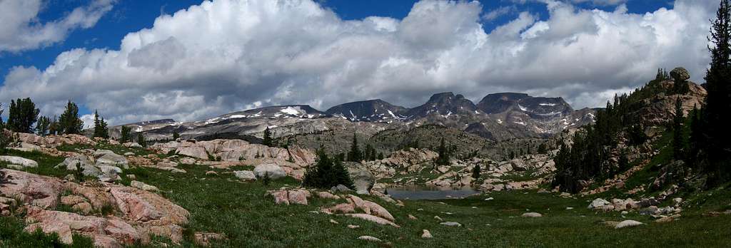
 Castle Group from Flat Rock Lake Castle Group from Flat Rock Lake | 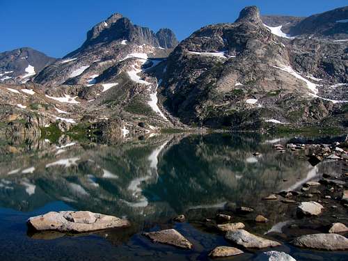 Point 12,540 and Castle Mountain reflecting in Varve Lake Point 12,540 and Castle Mountain reflecting in Varve Lake |
Castle Rock Mountain East Ridge/Varve Lake
Ratings: YDS - Class 2, Exposure - 2, Bushwhacking - 1
Time: 5 hours one way from Crystal Lake
From Crystal Lake - 11.5 miles
 Navajo Tarn Navajo Tarn | 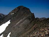 Castle Rock Mountain Castle Rock Mountain |  Point 12,540 Point 12,540 |
 Flat Rock Lake Flat Rock Lake | 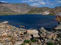 Copepod Lake Copepod Lake |  Descending Darlene S Slopes Descending Darlene S Slopes | 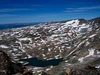 Darlene from Sky Pilot Darlene from Sky Pilot |
Castle Rock/Darlene Traverse
Ratings: YDS - Class 2, Exposure - 2, Bushwhacking - 0
Time: 45 minutes one way
From the summit of Castle Rock Mountain, hike west 0.3 mile over the summit plateau to where it narrows into a ridge at 12,290 feet. Descend the easy class 2 ridge for 0.3 mile to the 11,870 foot saddle. Ascend talus up the east ridge of Darlene for another 0.3 mile to the summit. At 12,120 feet, climb a short 50 foot narrow gully to gain the summit plateau.
One Way Distance - 0.9 mile
North side snow route descriptions via Whirlpool Creek to come soon!
Map
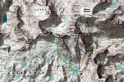
RED: Approach 1; Crystal Lake/Varve Lake from the south
ORANGE: Approach 2; West Fork Rock Creek/Omega Pass/Varve Lake from the west
PURPLE: Castle Mountain South Slopes Route (Class 2)
LIGHT GREEN: Route to the saddle between Castle Rock Mountain and Point 12,540 (Class 2)
DARK BLUE: Point 12,540 West Ridge Route (Class 4)
LIGHT BLUE: Castle Mountain East Ridge Route (Class 2)
PINK: Traverse from Castle Rock Mountain to Point 12,090 (Class 3)
GREY: Traverse from Castle Rock Mountain to Darlene Mountain (Class 2)
Camping/Red Tape
There is great camping at the north end of Crystal Lake and Shadow Lake as well as many places along the Beartooth High Lakes trail. Camping is also available at all the trailheads. This area is within the Abasorka-Beartooth Wilderness therefore no motorized travel, including but not limited to, cars, motorcycles, bicycles, hang gliders, airplanes, scooters, etc... is allowed.Please practice leave no trace practices and do not disturb wildlife. You are in grizzly bear country here so always carry bear spray, or a gun, or both for protection only if you are attacked. Report any bears you may have killed or injured to a ranger as a result of any defenses you may have taken.
There is a ranger office right at the junction of US Highway 212 and the West Fork Road at the southern end of Red Lodge.
External Links
Weather ForecastAvalanche Forecast
Absaroka-Beartooth Wilderness Info
Cooke City Information
City of Red Lodge