
-
 8536 Hits
-
 85.87% Score
-
 21 Votes
|
|
Mountain/Rock |
|---|---|
|
|
39.12538°N / 106.4913°W |
|
|
Lake |
|
|
Hiking, Mountaineering, Skiing |
|
|
Summer, Fall |
|
|
13876 ft / 4229 m |
|
|
Overview
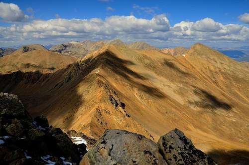 Frasco Benchmark as seen from Casco Peak Frasco Benchmark as seen from Casco Peak |
Frasco Benchmark 13,876 ft / 4229 m
Because of its lack of prominence (less than a 300 foot drop in the connecting saddle, etc.) Frasco Benchmark is considered part of French Mountain's lineage. Nevertheless, it's well worth the hike as it provides a nice break between both French Mountain and Casco Peak in Colorado's Sawatch Range in Lake County.
Frasco Benchmark is on the ridge between French and Casco, 0.5 mile west-southwest of French and 0.8 mile north of Casco. Frasco is unranked thirteener, but it is in an important topographic position at the intersection of three ridges.
Routes:
East Ridge
From Halfmoon Creek TH at 10,240 ft
Round Trip10.4 , Elevation 3,636 ft, Class 2
From 4WD PARKING AT 10,800 ft
Round Trip 8.4 mile, Class2
This is the easiest route on Frasco Benchmark. Start at the Halfmoon Creek Trailhead and follow French’s South Slopes Route to Friscol, the 13,620-foot saddle between French and Frasco. From Friscol, hike 0.35 mile west-southwest on a ridge to Frasco’s summit(Class 2)
----------------------------------------
South Ridge
From North Lake Creek TH at 10,780 ft
Round Trip 7.5 mile, 3,096 ft, Class 2+
Start at the Halfmoon Creek Trailhead and go 0.5 mile west on FS 110 (Halfmoon Road) to the start of the North Halfmoon Creek Trail at 10,500 ft. Continue 2.7 mileswest then southwest up FS 100 to the turnfor the Champion Mill at 11,540 ft. Do not enter the Champion Mill, which is private, but stay on FS 110 and cross to Halfmoon Creek’c south side. Continue 1.2 miles southwest then south on FS 110 to the 12,460 –foot sadle between Frasco Benchmark, which is 0.7 mile east, and mount Champion, which is 0.8 mile west-nortwes. From the saddle, descent 0.3 mile southeast on easy terrain and join South Ridge Route in the basin at 12,260 ft.
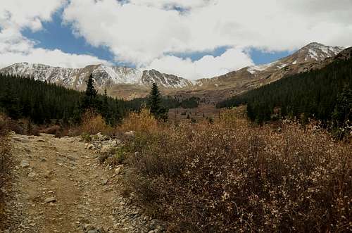 Trail from Halfmoon Creek Trailhead is more than obvious. Trail from Halfmoon Creek Trailhead is more than obvious. |
Getting There
Getting there:
There are two main trailheads: Halfmoon Creek Trailhead, and North Lake Creek Trailhead.
Halfmoon Creek Trailhead: Provides access to the north, east, and south sides of French Mountain, via a road that encircles half the mountain. Drive 3 miles south of Leadville on U.S. 24, and turn west on Colorado 300. Go 0.7 miles west, then turn south onto Lake County 11. Follow signs to Halfmoon Campground and Halfmoon Creek. Pass the Halfmoon Campground, the Elbert Creek Campground, and the Mount Massive Trailhead. Park at the junction of two roads, 2 miles past the Mount Massive Trailhead. With a 4WD vehicle you may be able to proceed farther, south from the trailhead.
North Lake Creek Trailhead: Provides access to French Mountain's west side, via Frasco Benchmark (13,876 ft.) and possibly Casco Peak. The trailhead is right off of Colorado 82, 19 miles west of the U.S. 24 - Colorado 82 junction, at the base of Independence Pass. Locate the tiny, unmarked turnoff just 100 yards before you reach the first major switchback on Independence Pass. There is ample parking space.
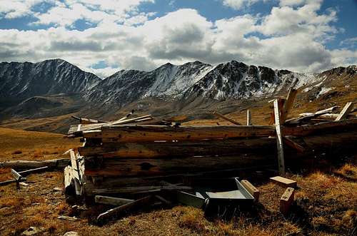 Remains of Iron Mike Mine. Remains of Iron Mike Mine. |
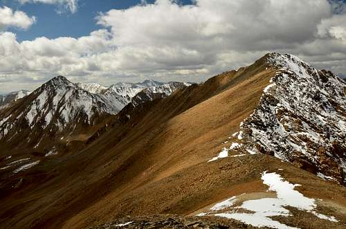 Frasco Benchmark and connecting ridge to Casco Peak Frasco Benchmark and connecting ridge to Casco Peak |
Red Tape
This mountain is in the San Isabel National Forest, where visitors are subject to Federal Regulations. Read the rules, which address camping, vehicles, camp fires, pets, and several other issues.The Arapaho and Roosevelt National Forests and Pawnee National Grassland
Camping
CampingThere is camping at the Halfmoon Campground and the Elbert Creek campgrounds. This would be fee camping and it gets really crowded in the summer, so you might want to call ahead. There are also places along the road that you can find to use free of charge. Look for pulloffs that don't have a car in them. There are also some free camping spots if you want to drive past the FS110-FS1103A junction at mile 9, probably about a mile or two continuing up the road. San Isabel National Forest 1920 Valley Drive Pueblo, CO 81008 (719) 545-8737
Weather
Google Map
View 13ers - Sawatch Range in a larger map