
-
 13720 Hits
-
 84.12% Score
-
 18 Votes
|
|
Mountain/Rock |
|---|---|
|
|
46.67500°N / 12.32597°E |
|
|
Trentino Alto Adige |
|
|
Mountaineering |
|
|
Summer |
|
|
10341 ft / 3152 m |
|
|
Overview
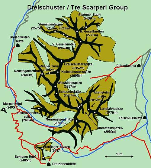
Geographical classification: Eastern Alps > Dolomites > Dolomiti di Sesto > Punta dei Tre Scarperi
Punta dei Tre Scarperi 3152 m
What's New on this Page?
* Jul 28, 2017 - Ownership switched by andrea
* Jul 31, 2017 - Page under review
"Punta dei Tre Scarperi" 3152 m - Dreischusterspitze in german - is the highest peak of the "Dolomiti di Sesto" group, and the Northernmost mountain in the Dolomites overcoming 3000 meters. Its importance can be almost compared to the major surrounding Dolomites mountains, like “Cristallo”, “Antelao” and “Croda dei Toni”. It is a mysterious and regal mountain and when seen from the North it looks like a majestic pyramid, while the East and West sides take the shape of a jagged ridge with walls cut by gullies. Great is the effect of seclusion for those who climb its slopes, featured especially by the length and the difficulty of access. Its flanks doesn’t host any refuges or bivouacs, no "Via ferrata" or important paths. Just few routes indicated by rare cairn.

Because of the length of the approach, the lack of convenient trails, the wild and fearful aspect that the whole chain inspires, the ascent of this peak (even across the Normal route with difficulty degree of I and II UIAA and some steps of III) is reserved only for skilled climbers of limestone. Moreover it reguires good sense of orientation. The first part of the East Normal route (Via Grohmann) is not easy to find but it is not particularly difficult, apart the access channel which is very landslide. The second part of the climb is long and with more difficulty, alternating stretches of I and II degree, while in the channels of the final approach to the top you will find a few brief grade III. It is important to keep in mind that it is a long climb with some problems of orientation, with the greatest difficulties concentrated in the final and that requires great experience in this kind of environment, not to be underestimated. The approach may be done either from the west, from “Val Campo di Dentro” or from “Val Fiscalina”.
")
|

|
The original name of the mountain was given in the 1770 as: “Drei Schuster Berg” and after in the 1845 as ”Gsellknoten”. The first and the definitive name would be connected to a local legend about three shoemakers of Sesto that were hunting for deers. The group is separated from the remnant of the Dolomiti di Sesto group by the “Passo Grande dei Rondoi” 2289 m and delimitated by four valleys: “Val Fiscalina”, “Val di Sesto”, “Val Campo di Dentro (Innerfeldtal)” and “Val Sassovecchio (Altensteintal)”. Other minor summits of the group are: “Punta Piccola degli Scarperi (Kleiner Schuster)” 3095m, the “Punta Lavina Bianca (Weißlahnspitz)” 2987m and the “Lastron degli Scarperi (Schusterplatte)” 2957m


|

|
Getting There
Punta dei tre Scarperi is located on the Northern part of the "Dolomiti di Sesto", a group of mountains on the border between "Alto Adige" and "Veneto" regions. The starting village to climb is Sesto, located along the Valle di Sesto, a branch of the larger Val Pusteria. The road approach can be done from both sides, but the Alto Adige side has two valleys at the foot of the peak and two refuges, even if far from the summit.
From Bolzano-Alto adige:
From Autobrennero motorway exit Bressanone and take the Val Pusteria, following the indication "Val Pusteria/Dobbiaco". Pass Dobbiaco and after the village of S.Candido/Innichen turn to right towards Sesto/Sexten, reaching Sesto, then Moso. In Moso turn to right to Bagni di Moso and Val Fiscalina. From Veneto:
For who comes from the Veneto side, motorway A4 from Milano or Venice, motorway A27 to Belluno, SP 52 to Auronzo di Cadore , then valle di Sesto.
"Val Campo di Dentro" and "Val Fiscalina" start from the village of "Sesto" 1316 m and they start very close to each others.
- Val Campo di Dentro hosts the refuge "Tre Scarperi" 1626 m, easily reached in 1 hour from the car park few km beyond Sesto. - Val Fiscalina hosts the private refuge "Fondovalle" 1548 m. Not far from the car park, it is also the starting point to get the refuges "Comici", "Pian di Cengia" and "Locatelli". Both the car parks can also be reached by a good bus services, for who wants to do hikes from different parts of the group.
The group photo from: Gangolf Haub
The Normal route
Punta Tre Scarperi Normal route
Summit: 3046 m
Difficulty: Alpine PD+,II/III III+ max
Difference in level: 1700 m
Starting point: Refuge Fondovalle (Val Fiscalina)
Walking approach
From the parking lot of Val Fiscalina take the road that leads to the refuge Fondovalle, then just past the horse stables on the right take a trace of path that goes right into the woods, very narrow in the begin with low pines, heading for the "Lavina Bianca" (pay attention to the deviations, always follow the left path, some small cairns remains from the Austrian warpath). Once having reached the end of the vegetation, continue penetrating in the center of the gravelled slope "Lavina Bianca" and carry on up the spur that descends from Tre Scarperi summit (on the way you will find the remains of the Austrian barracks). To the right there are the paths leading to the "Macchie dei Scarperi" and the "Forcella dei Sassi". This notch can be also reached from the refuge "tre Scarperi" on the opposite side of the mountain. Once passed a first channel you get to a second steep channel on the right (hard ground and landslide on the surface) to a kind of notch at its end. During that step keep yourself on the left of the channel, leaning against the wall. From the saddle, go up for few hundred meters along the steep cliffs, until you reach the edge of the large terrace sloping. You can walk across the terrace or at the bottom (a lot of attention to the jump below!); or walking in unwieldy screes that run through it.

|
")
|
Start of the climb
Climb up into short channels with low difficulty (grade I and II), stretches of trail, easy ledges and stretches of walls for at least 7/8 pitches (although it is not always necessary to rope up). Some cairns indicate the itinerary, but you never have to exceed the edge of the left. Later the route goes up across an area of black couloirs, above which it reaches the ledge that supports the different summit towers. Among these, the higher point is recognizable by a small black roof on its right side. Enter a rocky channel to the right of that tower and climb up (anchors of progression and for rappels, passages of III+) eventually coming under the aforementioned roof. From here you can climb up the chimney, or reach the notch where the channel ends and continue along the ridge, on the left. Reached the crest of carving you soon touch the top of Punta dei Tre Scarperi.
Huts

- Rifugio Fondovalle/Talschlusshütte 1548m: Placed in the Val Fiscalina From Piano Fiscalino 1454m in 1 hour Open from mid of may to end of october and from Christmas to Easter Keeped by fam. Villgrater Tel. +39 0474710606 Fax: +39 0474710921 Website: www.talschlusshuette.com
- Rifugio Tre Scarperi/Dreischusterhütte 1626m: Placed in the Val Campo di Dentro From the carpark in Val Campo di Dentro 1509 in 1 hour Section of Alpenverein Südtirol - Sezione “Drei Zinnen“ Open from 1 june to 30 september 56 places Keeped by fam. Innerkofler Tel. +39 0474966610 +39 0474976269 +39 3407698342 Website: www.drei-schuster-huette.com
Meteo
Meteo Provincia di BolzanoGuidebooks and maps

Links
Val Pusteria website linkSud Tyrol/Val Fiscalina link
Sesto/Sexten link
Wheather Val Pusteria link
Dolomiti Meteo link