
-
 14506 Hits
-
 83.55% Score
-
 17 Votes
|
|
Mountain/Rock |
|---|---|
|
|
46.63801°N / 12.37713°E |
|
|
Alto Adige/Veneto |
|
|
Mountaineering |
|
|
Summer |
|
|
10144 ft / 3092 m |
|
|
Overview
Geographical classification: Eastern Alps > Dolomites > Dolomiti di Sesto > Cima Undici
Cima Undici 3092 m
What's New on this Page?
* Jul 28, 2017 - Ownership switched by andrea
* March 27, 2018 - Overhaul of the page
Not to be confused with the Cima Undici located in the Monzoni-Vallaccia group, Val di Fassa, Western Dolomites, the peak described in this page is a 3000s located in the Dolomiti di Sesto. Cima Undici 3092 m - also called in Südtyrol as “Elferkofel” - is one of the wildest and most secluded peaks of the Eastern Dolomites and it appears like a steep ridge of jagged pinnacles, spiers and towers separated by numerous narrow forks, oriented North to South. The harsh and lonely environment inspires fear, but also unique beauty with an unrivaled charm, both in reason of the mountaineering history of the early pioneers and the incredible historical events that have occurred here during the WWI. Like various other peaks in this sector of the Dolomites, Cima Undici was a fighting theater during the Great War. In fact this lonely peak is located on the watershed between the provinces of Belluno and Bolzano, a historic border point of fierce clashes.
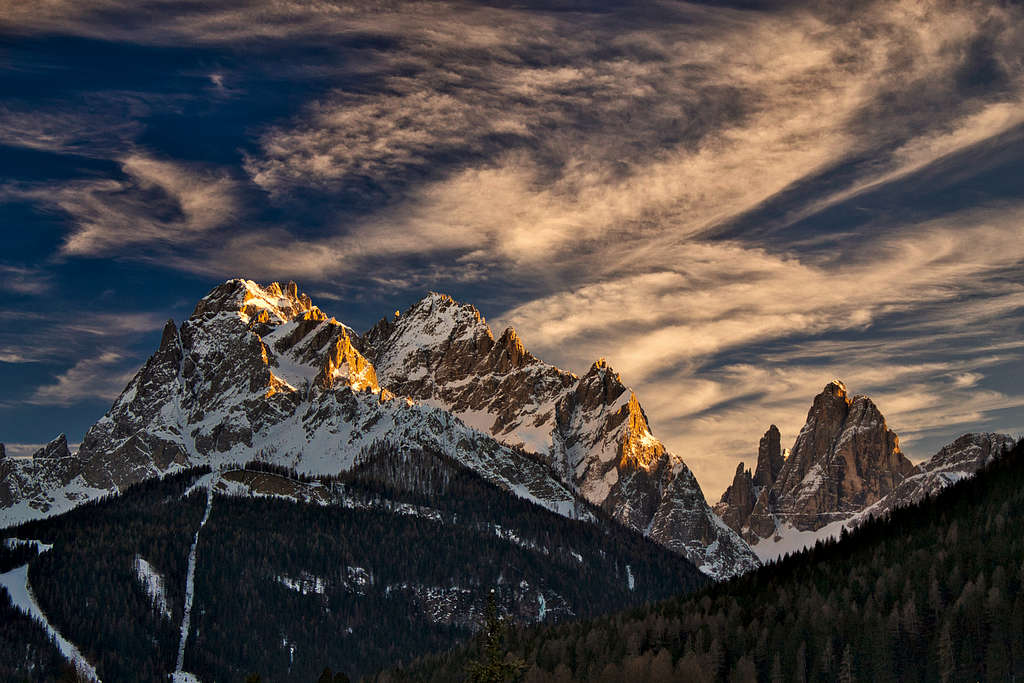
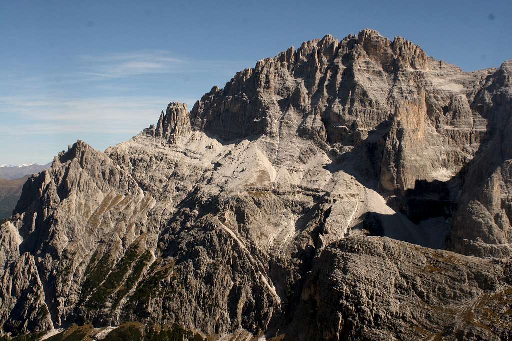
Cima Undici consists of two distint peaks, the North summit 3068 m and the South 3092 m, the highest, and dominates the “Val Fiscalina” with its stunning pyramid shape and with a succession of rocky couloirs converging towards the summit, that seen from this side seems unique. On the opposite side (East), its rocky walls lose grandeur next to the neighbours Monte Popéra and Croda Rossa di Sesto. It hosts the hardest climb routes.
The name “Undici”, means the “eleventh” top of Sesto. Some of the peaks of this area are called with numbers by the inhabitants of Val Pusteria, because they indicate the sundial viewed from the village of Sesto; like: "Einserkofel" (one), "Zwolferkofel" (twelve), "Elferkofel" (eleven).
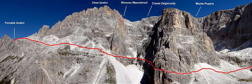
The West side is crossed by a funny trail equipped with chains, called the "Sentiero degli Alpini/Alpiniweg", which remains more or less always at the same altitude, connecting "forcella Giralba" 2431 m to "Passo della Sentinella" 2717 m, across "forcella Undici" 2650 m. The path is also the starting point to the Normal routes of the two summits.
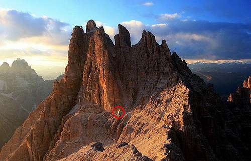
South side. The red circle indicate the bivouac "Mascabroni"
On the South side of the mountain was placed a bivouac, called "Ai Mascabroni" 2932 m. It's in a secluded and very panoramic location, also useful for those who climb the South summit. This mountain has been place of fierce fighting for its conquest during te WW1, and today it still hosts remnants of war barracks. As the neighbour mountains it was in the past part of Austrian territory, today it's located in the Italian one.

|

|
Features
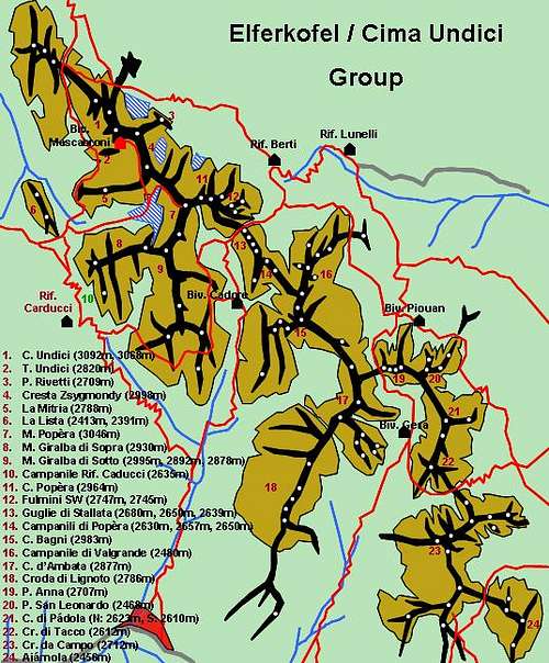
The limits of the mountain are:
From north: “Passo della Sentinella” 2717m
From south: “Forcella Zsigmondy” 2874m
Secondary peaks and notches along its ridge. From south:
“Forcella della Tenda”
“Forcella 75”
“Torrioni di Cima Undici”
“Forcella della Caverna”
“Cima Sud”
“Forcella da Basso”
“Cima Nord”
"Forcella Sala”
“Forcella da Col”
“Forcella dal Canton”
“Forcella del Canalone”
“Punta del Pastrano” Also “Torre Undici” (Elferturm) 2820m but separated from the main ridge

Getting there
The group photo from Gangolf Haub
Cima Undici is placed on the Eastern part of "Dolomiti di Sesto" group. Group of mountains on the border between "Bolzano Alto Adige" and "Veneto" regions. The approach can be done from both sides. Its Normal routes are placed on the west side of the mountain. The most accessible points are the aforesaid "Passo della Sentinella" and "Forcella Zsigmondy". They can be reached from two sides:
From Alto Adige: Sesto - Val Fiscalina - Refuge "Comici" - Sentiero degli Alpini - Forcella Zsigmondy Sesto - Val Fiscalina - Refuge "Fondovalle" - path 124 - Passo della Sentinella Sesto - "Refuge Rudi" - Rothwand kletterweg - Passo della Sentinella
From Veneto: Padola - Val Risena - "Refuge Berti" - path 101 - Passo della Sentinella
The village of Sesto il placed along the "Valle di Sesto" which belongs to the bigger "Val Pusteria" of Dobbiaco. From the motorway that connect Austria to Italy across the "Passo del Brennero", take the gate "Brunico/Brunek", follow the indication to "Val Pusteria/Dobbiaco", and than shortly to "S.Candido/Sesto".
For who comes from the Veneto side, motorway A4 from Milano or Venice, motorway A27 to Belluno, SP 52 to Auronzo di cadore and indications to Giralba or Padola.
History
Mascabroni is the gergale name - translatable with the meaning of proud, brave and a bit arrogant - with which it became famous a small team of italian Alpine soldiers that operated on the crests of Cima Undici, during the Great War between 1915 and 1916, with the task of reaching various advanced places to obtain observation positions and finally do the assault of surprise to the enemy stations of the Passo della Sentinella. After two months of fights against the frost at over 3000 meters of altitude, on April 16th, 1916, two special Alpine teams, formed by expert climbers from the Battaglione Fenestrelle and Battaglione Pieve di Cadore, chosen among the most athletic and determined and commanded by Captain Giovanni Sala, rolled from the high forks of Cima Undici to conquer the Passo della Sentinella That handpiece of daring alpine soldiers will always be remembered as "the Mascabroni".
More info: Cima Undici, 100 anni
Normal Routes
Cima Nord 3081 m Normal route
Exposure: ENE
Length: 370m from Passo della Sentinella
Difficulty: I/II UIAA, PD-
The Normal route nowaday followed to Cima Nord is not difficult, but it's a strenuos itinerary, with a long approach to Passo della Sentinella. There are two routes, the original Witzenmann and the Berti, although the first one is now in disuse due to the dangerous crossing of the upper part of the "Great Snow Gully" along which it occurred the famous "Descent of the Mascabroni". The loose rock and the lack of signage make Witzenmann only suitable to skilled mountaineers, expert on crumbling ground. The route described here is the Berti, which has minor difficulties and it's affordable by experienced scramblers, able to move on impervious and loose ground.

Approach to Passo della Sentinella
From Rifugio Lunelli in Valgrande 1568 m, reachable by paved road from Padola or from the Monte Comelico Pass, take the path 101 to the Rifugio Berti 1950 m. (about 45 minutes). From here climb up the Vallon Popera, getting at first the Lake Popera and then, climbing a moraine ridge in the middle of the Vallon Popera, getting the walls of the Croda Rossa di Sesto. From the junction to the Ferrata Zandonella, which you must leave on the right, descend on the old, now collapsed path, in the middle of Vallon Popera, to get briefly the Passo della Sentinella 2717 m (2.15 hours from Rifugio Berti).
Route report - From "Passo della Sentinella", reverse a little along the approach route, and go down a few steps towards southeast to cross a snowy couloir (the famous "Calata dei Mascabroni"), then going to get an obvious terrace covered by debris. Without moving too far to the left, climb immediately the rocks above. There is not a binding route. Climb up on rubble, rocks and crumbly gullies (some passages of I UIAA), in practice flanking the snowy couloir. Some rare little cairns. After climbing up on strenuous gravel slopes, take a narrow gully with some snow. From here many cairns lead to a ledge covered by debris where you go leftwards getting a small saddle (cairn). Carry on rightwards on very loose rock always following the cairns (I+), until you reach a terrace covered by debris at about 3000 meters of altitude. To the left, under the rocks, following a good track leading through two crumbly gullies until you come uphill to a saddle. Rightward, then climb straight on an exposed wall (I and II) for about 30 meters, exiting to a notch - Forcella Sala - and from here briefly to Cima Undici - Punta Nord 3068 m. (vertical gain 370 m from Passo della Sentinella, 2 hours).
West side - "Sentiero degli Alpini" marked in red - Ph. andrea
Cima Sud 3092 m Normal route
Exposure: SSE
Length: 160m from the Forcella della Caverna
Difficulty: II/III-, PD+
Route report - The route start from the "Forcella della Caverna". This point as the neighbor bivouac Mascabroni, can be reached from the "Sentiero degli Alpini" or, much better along the whole traverse of the "Cresta Zsigmondy". Much safer and also it permits to climb first of all the close "Monte Popera" The approach to the south terrace "La Mensola" can also be made along the route "Zsigmondy-Purtsheller" from "Busa di Dentro". The friability of the rock, the landsliding of channels, the lack of signaling and the complexity of the route can make the climb only to experienced climbers and practical land friable in severe environment. The whole traverse from "Forcella della Caverna" to the notch at the foot of the Cima Sud is very delicate, and for the crumbly soil that for no single points of insurance, except for some rare old anchors which should verify the reliability. Although the crossing takes place on a bank rather large especially in snowy or icy gravel hardened by frost, which make the cross very dangerous. The route is suggest in late summer and only in the absence of snow and ice, with temperatures that thaws the ground debris, and only under great time and the absence of clouds. Better to use a rope 60 meters long.

|

|
Red Tape
No fees no permits required. The whole group is included among the nine ones acknowledged as an UNESCO World Heritage Site in 2009. More info about Dolomiti Unesco World Heritage here:
- in the article by Silvia Mazzani: Dolomites living mountains
- on the Unesco Official web-site: Unesco
- on the Fondazione Dolomiti Unesco web-site: Fondazione Dolomiti Unesco
Huts and Bivouacs

- Rifugio Zsigmondy-Comici 2224 m
Situation: Val Fiscalina
Access: from Campo Fiscalino 1454 m 2/2.30 hours E
Owner: CAI sez. Padova
Keeper: Nikolaus Happacher Tel. +390474710358
Places: 98 + 6 winter
Open: from june 30th to september 30th

- Rifugio "Berti al Popera" 1950 m
Situation: Vallon Popera
Access: From Rifugio Lunelli 1568 m, reachable by paved road from Padola or from Passo Monte Comelico, 1 hour on path n. 101 E
Owner: CAI sez. Padova
Keeper: Bruno Martini
Phone: tel. +39 043568031 Tel. +390436/67155
Places: 56 + 8 winter
Open: from 25th june to 25th september

- Bivacco Ai Mascabroni 2932 m
Situation: at the foot of the Cima Sud From the Refuge Zsigmondy-Comici along the Cresta Zsigmondy in 4 hours F
Owner: "Giovane Montagna" sez. Vicenza
Places: 9
Permanently open
When to climb
Summertime
Meteo
ARPA Dolomiti Meteo
Meteo Provincia Bolzano
Guidebooks and maps
 |
 |
- Guidebooks
- 3000 delle Dolomiti - Ed. Idea Montagna, Collana "Vie Normali", 2012
- Dolomiti Orientali Vol. I Parte II - Antonio Berti, Collana Guide dei Monti d'Italia
- Maps
Tabacco sheet 010 – Dolomiti di Sesto - Sextener Dolomiten 1:25.000
External Links
Val Pusteria website link
Sud Tyrol/Val Fiscalina link
Sesto/Sexten link
Wheather Val Pusteria link
Dolomiti Meteo link