
-
 15176 Hits
-
 86.85% Score
-
 23 Votes
|
|
Mountain/Rock |
|---|---|
|
|
48.88662°N / 113.62339°W |
|
|
Hiking, Mountaineering, Scrambling |
|
|
Spring, Summer, Fall |
|
|
8966 ft / 2733 m |
|
|
Overview
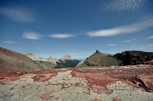
Yellow Mountain is an obscure and remote peak located in the extreme northeast corner of Glacier National Park. It is, as one would expect, comprised of yellow rock, which makes the peak easy to pick out from vantage points along the eastern front. However, those that have traversed Yellow Mountain's winding ridges will be the first to tell you that this area features a kaleidoscope of colored rocks. Magnificent formations of red, grey, black, green and white rock can be found littered across its many loose slopes.One of the joys of experiencing this corner of the park is its remoteness. Most human visitors to the area are on multi-day backpacking trips and stick to the beautiful Redgap Pass Trail, so human traffic is very light on Yellow Mountain. As such, it is a paradise for mountain goats and bighorn sheep, and off-trail hikers often utilize their indelible trails to navigate this area. One of these goat trails provides a spectacular shortcut route from Ptarmigan Tunnel to Redgap Pass, while a maze of additional game trails meanders across the seemingly endless ridge tops. This is truly a magical place, and one that any Glacier Park junkie should visit at least once.
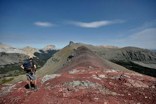
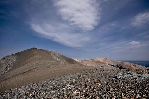
Pondering the winding ridge that leads to the summit of Yellow Mountain.
A note regarding a discrepancy I have observed regarding the true summit elevation of Yellow Mountain. USGS quads show a highpoint of 8,966 feet, which is in fact the highest point on the Yellow Mountain massif. However, both J. Gordon Edwards and the popular National Geographic Trails Illustrated maps of Glacier reference a highpoint of 8,766 feet. Anyone who has been to Yellow Mountain will tell you that the true summit is east of Point 8766. Since many people utilize the Trails Illustrated maps, I thought I'd include a photo of the map with correct summit identification.
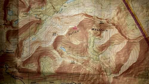
The true summit of Yellow Mountain is not labeled on Trails Illustrated topo maps.
Getting There
Yellow and Chief from US-89
Two approach options exist farther to the north from Montana Highway 17 (Chief Mountain Highway), a bumpy paved road that begins four miles north of Babb off US-89. They will be discussed in some detail in the "Route Information" section below.
Routes
The summit of Yellow Mountain is atop an extremely long, meandering ridge. As such, all paths to the summit require a lengthy approach. Several route options are outlined below, but by no means is this a definitive list. This massive mountain has limitless route options, and I've only chose to include routes that I know have been completed by climbing parties.
Ptarmigan Tunnel to Redgap Pass via Goat Trail with Descent to Poia Lake
In my opinion, this is most exciting and scenic route. By utilizing two cars, parties can make this into a long, exciting circuit route. The starting point is the Iceberg/Ptarmigan Trailhead near Swiftcurrent Motor Inn. Shuttle an additional car to either the Many Glacier Entrance Station or the Apikuni Falls/Poia Lake Trailhead, both east of Many Glacier Hotel. You will thank yourself at the end of what will almost certainly be a very long, tiring day! Elevation gained from the trailhead to the summit is just over 4,000 feet. I estimate that there is an additional 2,000+ feet of elevation gained over the course of the route. As for distance, the circuit route varies between 20-24 miles long, depending on the chosen exit point on Many Glacier Road. Nearly half is off-trail, so it will take even strong hikers a minimum of 10 hours to complete. A word of caution about the hike out from Poia Lake: many hikers are frustrated by 1,400 foot climb from the lake over Swiftcurrent Ridge. It's a tiring stretch, and disappointing in that you lose the 1,400 feet right back over the final three miles to the trailhead. I guess what I'm trying to say is, plan your day accordingly. Wait for good weather, and do not attempt the goat trail before the middle of July without ice axe, crampons, rope, and the ability to use them. Since this route may be a stretch for a day trip for some folks, I'll discuss options for shorter outings that involve backcountry camping farther down the page.
Please visit my route page for a detailed route description from the Iceberg/Ptarmigan Trailhead to Redgap Pass. In summary, hike the maintained trail through Ptarmigan Tunnel (5.1 miles and 2,300 feet of elevation gain). North of the tunnel, it is possible to scramble up to the ridgetop to the northeast and locate a marvelous goat trail that descends to Redgap Pass.
 Seward Mountain at left. The red bump at right is the first landmark on the long ridge to Yellow Mountain.
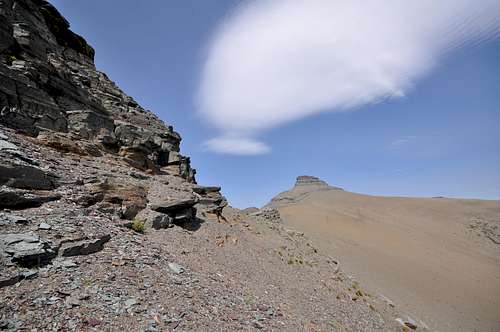
From here, there are two options, one of which includes the tiring, but easy class II slog up Seward Mountain. It's 1,400 feet, takes no more than an hour, and affords spectacular views. To continue to Yellow Mountain, simply follow the summit ridge east-southeast. The other option from Redgap Pass is to follow a fantastic network of of game trails that lead east across the great scree-covered southern slopes of Seward. Both routes head towards a small sharp red bump that protrudes on the ridge, where a well-worn game trail leads easily around the north face. Note that the area between the small red bump and Seward Mountain has been dubbed "Seward Saddle" by J. Gordon Edwards. Most parties will require a minimum of two hours to reach Yellow Mountain's summit from Redgap Pass.
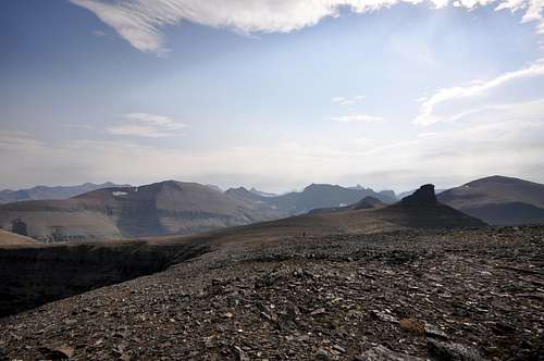
View north from "Seward Saddle"
Traversing around the first bump on Yellow's long summit ridge
Cross over to the east side of the ridge and follow it towards the northeast. You'll want to descend a few hundred feet to the east/southeast, as the rising ridge eventually ends in rotten, steep cliffs. Carefully down climb to the scree slopes below, then pick up a solid game trail and continue on the ridge towards a prominent tower of rock.
Safer terrain below the cliffs. Follow game trails towards the prominent tower of rock ahead, which is bypassed on the right.
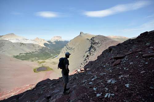
Bypass the tower on the right. As you continue eastward, take note of the broad ridge that branches off to the southeast; this is the fastest and easiest way back to Poia Lake, a solid human trail, and eventually civilization. A desolate basin with a shallow, unnamed lake soon comes into view east of the Poia Lake descent ridge. Continuing on, another rounded dome of rock protrudes from the ridge. Save your energy and try to resist gaining unnecessary elevation by climbing the dome; look for game trails that traverse its lower slopes. Once you've traversed to the opposite side, the summit block of Yellow Mountain finally comes into view. The view to the east is mesmerizing, as the rocks transition to a brilliant yellow hue.
The ridge at right leads to a route to Poia Lake.
FINALLY, the summit of Yellow Mountain (at left)!!!
The summit cairn is located at the eastern end of the block. The actual high point is NOT yellow, and it is nothing more than a tiny rise on top of a broad pile of rocks. Although the summit itself is not that spectacular, the views certainly are! The ridge continues on for what seems like forever, and could be followed all the way toward the east summit of Yellow (marked at 8,655 on topo maps), and out towards Sherburne Peak, but this would certainly add time to an already long day. Gordon Edwards describes this area as a "garish moonscape" (1), which I believe is quite fitting.
Descending Yellow Mountain. To head to Poia Lake, take the ridge at left.
Poia Lake Trail
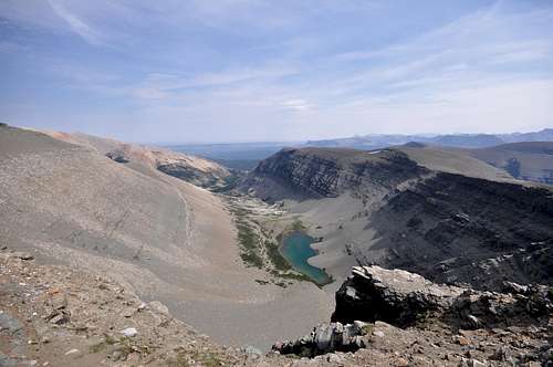
 Multiple routes exist on the south slopes near Poia Lake
Slide Lake Approach
 Yellow Mountain viewed from the outlet of beautiful Slide Lake.
Alternate Poia Lake Route
The group that I mentioned above took an interesting ascent route from near Poia Lake that is at least worth noting. On the Many Glacier National Geographic Topo Map, Point 6432 is marked just to the east of Poia Lake. Several drainages confluence in the vicinity of this point, and eventually tumble over a large cliff into Kennedy Creek in the form of a beautiful waterfall. The group began climbing a bit east of the falls, heading generally towards Point 6432, from where they simply followed the incredible ridge towards Sherburne Peak. They did not venture out to Sherburne, but rather followed the ridge over Yellow's east summit (8,655 feet) all the way to the main west summit. From there, they descended to the northwest and camped in the expansive meadows of the Seward Mountain drainage. The next day they hiked over Gable Pass and down Lee Ridge in what sounds like an incredible trip! I hope to attempt this alternate ascent route in 2013, and will be certain to update this page when I have more information.Summit Views
When to Climb
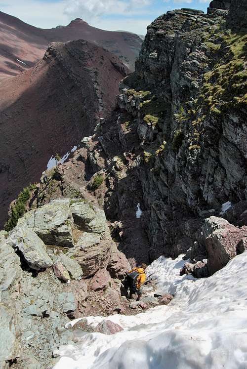
Squeezing around snow in mid-July on the goat trail to Redgap Pass
Snow will greatly complicate the goat trail connecting Ptarmigan Tunnel to Redgap Pass, so it's best not to attempt this route before mid-July. Some amount of snow will likely remain on/near the goat trail for the duration of the summer, but enough melts off to where a safe path can be taken. If you arrive at the entrance to the goat trail and find the path blocked by snow, it's best just to turn around and live to see another day. The Yellow Mountain ridge is incredibly long, and very exposed. Afternoon thunderstorms are common during the summer in the northern Rockies, and I can speak from experience that this ridge is a very bad place to be when the weather turns. It's best to attempt this ridge walk when the forecast is in your favor.
Where to Stay
The fantastic Many Glacier car campground is located at the terminus of the Many Glacier Entrance road, one mile past the Many Glacier Hotel. The campground has 109 sites and as of November 2016 fees are $23 per night. Be forewarned: describing Many Glacier Campground as busy in the summer months is nothing short of an understatement. From mid-June to Labor Day, the campground almost universally fills well before noon. As of 2016, the NPS has implemented a reservation system and half the sites are reservable in advance. The remaining sites are available on a first-come, first-serve basis only. If you do not have a reservation, I recommend arriving before 7am to line up in the queue of walk-up campers. Information on historic campground fill times, reservations and camping regulations can be found on the NPS camping webpage.
Many Glacier Hotel offers 215 rustic rooms in a spectacular setting on the eastern shore of Swiftcurrent Lake. The hotel turned 100 in 2015, and does not have many modern amenities. It is extremely busy during the summer, and the concessioner recommends booking several months in advance. Rates range from approximately $150 to nearly $300 per night, with the majority of rooms in the $200 range. Visit Xanterra’s website for more information. There are also numerous local lodging opportunities (campgrounds, motels, cabins) just outside the park in and around the small towns of Babb and St. Mary.
If you are interested in setting up a basecamp at either Poia or Slide lake, both offer backcountry campsites. As of November 2016, permits are $7 per person per night and can be obtained at various visitor’s centers (St. Mary and Many Glacier are nearest). There is an advance reservation system (and associated fee), or sites can be obtained on a walk-up basis. Please visit the NPS backcountry camping webpage for more detailed information.
Red Tape, Wildlife, Safety, etc.
Entrance Fees
A fee is required for all persons entering Glacier National Park. As of November 2016, single vehicle rates are $30 for a seven day pass, or $45 for an annual park pass (increasing to $50 in January 2017). A lower fee is charged for hikers and bikers; please visit the NPS fees webpage for a full explanation of the entrance fees.
Seasonal Closures
Glacier is subject to extreme winter weather conditions, and as such, much of the park is virtually inaccessible for the majority of the year. The Going-to-the-Sun Road is typically open in its entirety from mid-June to mid-September, and many of the developed areas of the park (including the historic lodges and most of the campgrounds) operate for a short window as well. Information on the operational status of front country campgrounds and park roads can be found by clicking on the hyperlinks.
Glacier Rock Grading
Due to the sedimentary nature of the rock in Glacier National Park, unique rock grading systems have been established by both Gordon Edwards and the Glacier Mountaineering Society. Please refer to the Glacier National Park Rock & Grading Systems Summitpost page (authored by Fred Spicker and Saintgrizzly) or the website of the Glacier Mountaineering Society for detailed information. If you are new to climbing in Glacier, I highly recommend checking out this info before attempting any climbs in the park. Oh, and don't forget to wear your climbing helmet!
A Climber's Guide to Glacier National Park
Pick up a copy of Gordon Edwards' classic A Climber's Guide to Glacier National Park. It's an absolute must for anyone who wants to safely venture to one of the park's many accessible mountain summits. Edwards spent many years as a seasonal ranger in Glacier, where he developed a deep passion for exploring the park's mountains and sharing its splendors with others. The book provides a fantastic history of climbing in Glacier, and his detailed and colorful route descriptions are a fantastic introduction to off-trail hiking and climbing in the park.
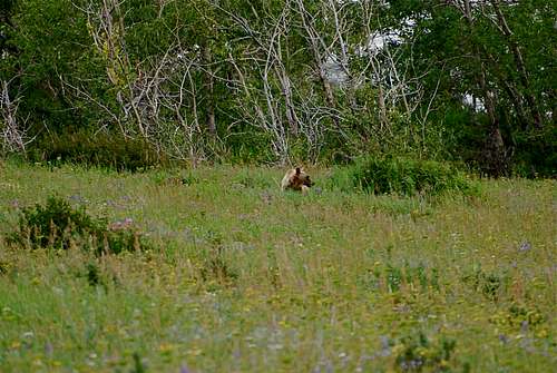
Hey bear!
The park is home to lots of potentially dangerous wildlife, including moose, black bear, grizzly bear, and mountain lion. Hike loud, carry bear deterrent spray (and know how to use it!), check local trail postings (for area warnings/closures) and let someone know your intinerary before heading out into the park. Also, note that special precautions are in place in all front and back country campgrounds to limit human-bear encounters. Regulations are posted everywhere (picnic tables, ranger stations, bathrooms) and it is every visitor's responsibility to take them seriously. Remember, a FED BEAR IS A DEAD BEAR! Please visit the NPS camping webpage for more detailed information.
External Links
Visit the FANTASTIC Glacier National Park page, a labor of love by late Summitpost member Saintgrizzly (R.I.P.), or the NPS webpage for more detailed information on "The Crown of the Continent".
References
1. Edwards, J. (1995). A Climber's Guide to Glacier National Park (1st edition published in 1961). Helena, MT: Falcon Press Publishing Co., Inc.