
-
 18807 Hits
-
 87.31% Score
-
 24 Votes
|
|
Mountain/Rock |
|---|---|
|
|
43.74490°N / 103.4816°W |
|
|
Custer |
|
|
Hiking |
|
|
Spring, Summer, Fall, Winter |
|
|
6023 ft / 1836 m |
|
|
Overview
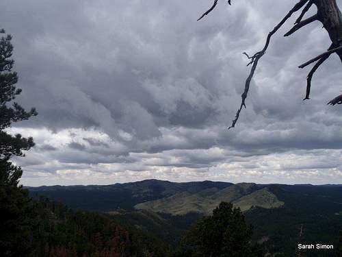
Views from summit
Located within Custer State Park, Mount Coolidge is perhaps best know for the fire tower that sits upon the summit. Built in 1937-9 by the CCC (Civilian Conservation Corps), the fire tower is still staffed from approximately mid-May to mid-October every year.
Mount Coolidge has suffered something of an identity crisis over the years. Originally called Sheep Mountain, the peak was renamed Lookout Mountain in 1923 only to be renamed again in 1927 to Mount Coolidge. Now, however, this mountain even has its own namesake USGS quad.
From the summit, the visitor can enjoy fantastic views of the surrounding Black Hills, including Mount Rushmore, Crazy Horse, the famous Needles and even Elsworth Airforce Base. It is said on a clear day, the Badlands can be viewed approximately 60 miles eastward. At the summit, informational kiosks tell about the 1988 Galena Fire that scorched 17,000 acres of the park.
Custer State Park is known for its population of a keystone species of this region, the American Bison. (Seriously, folks, admire these animals from a great distance!) According to National Geographic, this heaviest of North American land mammals can rise to 5 to 6.5 feet (1.5 to 2 meters) tall at the shoulder and weigh in excess of 1 ton (971 kg). Best yet, they sport pointed horns and can run at speeds of up to 40 mph (65 kph).
Rank: 53rd highest peak in South Dakotaka
Prominence: 683 feet
USGS Quad: Mount Coolidge
Planning Map: Trails Illustrated #238 Black Hills South
Rank & Prominence: Lists of John
| Summit fire tower and information about 1988 Galena Fire | ||
|---|---|---|
 |
 |
 |
Summit Views
| For a short hiking investment, this peak offers great views | ||||
|---|---|---|---|---|
 Summit Views Summit Views |
 Summit Views Summit Views |
 Summit Views Summit Views |
 Summit Views Summit Views |
 Summit Views Summit Views |
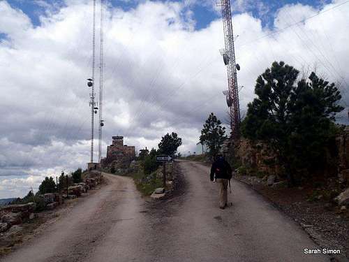
Getting There

Mount Coolidge Road sign

Beginning of the walk
Mount Coolidge is located 3 miles south of US Highway 16A along SD Highway 87. From here, visitors can drive 1.2 miles up the road to the lookout tower or park at the base of the road and stroll up. I will post a simple walk-up route page shortly.
Route Description
 Route to the top of Mount Coolidge via the road.31 May 2012 Route to the top of Mount Coolidge via the road.31 May 2012Roundtrip Distance: 3.4 miles Elevation Gain: 500 feet Time:About 1 hr YDS Class: 1 |
 Mt Coolidge summit Mt Coolidge summit  Lower on the road Lower on the road |
 Almost to the top Almost to the top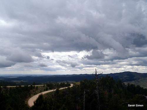 Looking down on road Looking down on road |
Red Tape
Mount Coolidge is located within Custer State Park of South Dakota. Per the state park:
•If the gate at the base of the mountain is open, visitors may proceed to the top.
•The road leading to Mount Coolidge is generally open 9 a.m. to 5 p.m. from Memorial Day into late September.
| Bison are a common sight in the valleys below Mount Coolidge | |||||||
|---|---|---|---|---|---|---|---|
 |
 |
 |
 |
 |
 |
 |
 |
Camping

Old snag

Nearing the summit
Elk Mountain Campground | National Park Service
•$12/night high season; $6/night low season
•First come, first served
•Running water and flush toilets (high season)
•Elevation 4,923 feet
Blue Bell Campground | US Forest Service
•$18/night (standard) or $22/night (electric hookup)
•35 sites
•Running water and showers
•Elevation 4,165 feet
Weather & Seasons
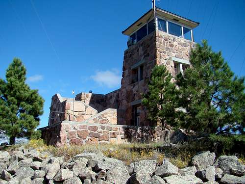
Mount Coolidge Historic Fire Tower | panhandletrails


