
|
|
Mountain/Rock |
|---|---|
|
|
48.06067°N / 120.98497°W |
|
|
Chelan |
|
|
Mountaineering |
|
|
Summer |
|
|
8400 ft / 2560 m |
|
|
Overview
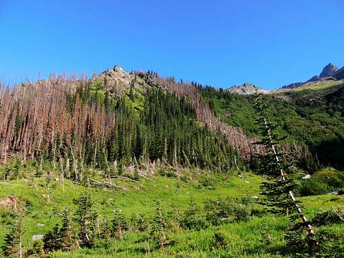
At approximately 8400 feet, Luahna Peak is the second highest point of the Dakobed Range (not counting Glacier Peak), located just northwest of higher Clark Mountain. It is rather remote by any route. It’s appeal to a climber may lie simply in that it is one of hundred highest, or perhaps that it is more remote and less-visited, thus providing a feeling of true wilderness. The difficulty in climbing this one is not in the final yards to the summit, but rather in just getting to it. During my crossing of the range and summit climb in August 2012, I encountered not a single human. The summit register shows many weeks and months often pass between signings, sometimes a few years, and has many pages yet to be filled despite being placed in 1992. So if you like your wilderness climbing uncrowded, this might be the spot for you.Approach from Butterfly Butte
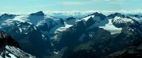
The glaciated side. Clark on the left, Luahna on the right. Butterfly Butte is in the lower right, reaching to the toe of the Pilz Glacier.
This is the glaciated (NE) side. This would require coming up from the Napeequa valley to the area labeled on maps as “Butterfly Butte”, then climbing one of the glaciers. This was my approach, up over the Pilz Glacier to then access the southwest side. Beautiful country, feels very wild and worth the effort, but also very demanding.
The Napeequa valley is a unique North Cascades destination, as one must hike over a pass to then descend into the valley, there is no hiking up from down valley like most mountain trips. Pick one of the two available, Boulder Creek Pass or Little Giant Pass.
Boulder Creek Pass means a start from the White River trailhead, which is at the end of the White River road. Walk a pleasant forest trail 4 miles to the signed junction with the Boulder Pass trail. Follow this 6+ miles and 3700 feet up to the pass. There can be a challenging ford mid-way up this trail depending on water levels. Great camps right on the pass if you’ve had enough for the day. Descend 2000 feet on increasingly overgrown trail (I’m guessing this side sees very little traffic) to the valley bottom and ford the unbridged Napeequa river. This can be knee deep or higher, but there are spots with slower current, not too overwhelming unless in flood stage… then it might be impossible.
Little Giant Pass means a start from the Chiwawa River road, about 19 miles up from County Road 22, signed as Chiwawa Loop near Lake Wenatchee. Walk the trail up 4400 feet over 4 and a half miles to the pass. From there, descend 2200 feet to the Napeequa River. This trail delivers you to the east side of the river, so no ford needed here.
Suddenly in meadows
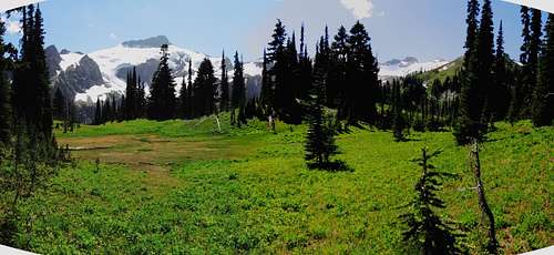
Once at this trail junction on the east side of the Napeequa, walk northbound approximately 2 easy miles to the Louis Creek crossing (forms a spectacular waterfall just above the trail here, can’t miss it… see photo entitled “Louis Falls”) and a couple hundred yards north of that find the first obvious clear brush-free access to the Napeequa River, down through open meadow. Head down and cross over. This can be challenging, choose your spot carefully, it was thigh-deep and fast when I waded across in mid-August 2012. The exploration-minded might very well find a better place to cross; I kinda wondered about a few hundred yards before the Louis Creek crossing in forest where there was an obvious campsite, perhaps cross the river there? Once across the river, apply your off-trail navigation skills and head uphill a thousand feet through mostly open and easily traveled forest and step into the beautiful and flowered meadows of Butterfly Butte (Photo “Suddenly in meadows of Butterfly Butte”). Continue across the flats and then up, choosing your path as you see fit. I headed for the pristine deep blue small tarn that shows on the map at 6500 (Photo “Tarn at 6500”), near the base of the Pilz Glacier, this went relatively smoothly with very little vegetation or terrain issues.
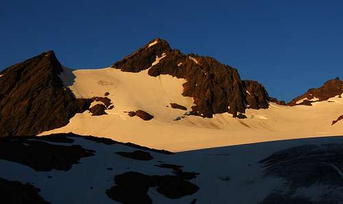
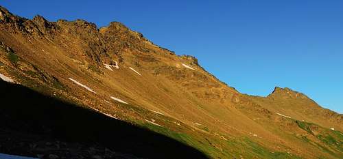
Luahna Peak at sunset, viewed from camp at toe of the Pilz Glacier
From there ascend the Pilz – there are a few minor crevassed sections and a bergschrund, which was bridged in mid-August 2012 – and climb through the low spot northwest of Luahna. If looking to set a basecamp on this southwest non-glaciated side of the range, there are good flat spots about 800 feet in elevation downhill to the west, around the obvious hanging basin. Most people would probably take two to three days to travel this route.
Approach from Thunder Creek to Luahna Basin
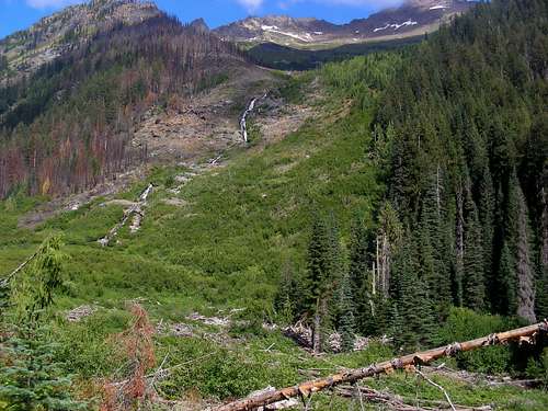
Lower Luahna looking up from Thunder Creek
Partway up Luahna basin, long way to go
Luahna Basin is the large bowl with the hanging basin to the SW of the peak, accessed at the end of the "Approach from Butterfly Butte" route description; this is a way to get to the same spot from another direction in a single day, but with some considerably difficult travel and navigational challenges. The first challenge would be finding the very well hidden trail up Thunder Creek from the White River trail.
First hike the White River trail a little over 6 miles to the Thunder Creek crossing. Continue past the creek about a half mile. Now the very tricky part: Finding the unmaintained way trail. For the past couple of years and as of August 2012, there are a series of large trees down across the trail. This is on a slightly uphill straightaway. One of these trees is about a foot in diameter, and is broken such that it forms a peaked archway over the trail, tall enough to walk upright under, almost like a formal entryway. From that stand still and look ahead up the trail, have your eyes find a tree trunk right next to the trail that has been chainsaw cut, very evenly, with the face of the cut tilted toward you, like a drafting table set for someone to sit at and do some work. It’s about two and a half feet in diameter, about waist height, right next to the trail. Walk up to that. The table-smooth face of that cut has a large arrow faintly but visibly scratched into it, pointing off north into the woods. Dial up your patience and explore in that direction. At first it may seem hopeless, but climb over a few logs toward some bushes, keep looking, and magically, between those bushes, an obvious trail suddenly materializes. It’s really obvious once you find it, and is only about 200 feet from the White River trail. I expect that sometime soon trail maintenance crews will cut all these down logs; when that happens the formal entryway log will be gone, the only clue left will be that drafting table-like stump with the faint etching of an arrow on it. This does sit right at the trailside, on the right, facing southeast, so hopefully that landmark will remain for some time.
Once on the Thunder Creek way trail, follow this uphill in woods on surprisingly good track… for awhile. Eventually you will come to an opening in the woods, an avalanche landing zone. Above you to the right is Luahna Basin and the peak way up there; might want to do some studying here (Photo “Lower Luahna looking up from Thunder Creek”). The trail fades into overgrown grass and brush, but the way is still decipherable, keep going across this green opening a few hundred yards to the other side. Immediately after re-entering woods, leave the re-appeared trail and head down to Thunder Creek. Find a place to cross. Then up into woods on the other side, and start the really hard part. Turn right out into the meadow, then look uphill, pick your path through all that. I recommend staying mostly left, using the burned out hillside despite the dust and ash, it is much more open then the dense 15 foot deep brush stuck to cliffs. (See photo “Partway up Luahna basin, long way to go”). The mule deer have stamped out amazingly useful trails in this ash. It gets very steep at times, but watch which way the deer trails go and there is always an amazing escape around the cliffy sections. Eventually you will clear the trees and arrive in the upper basin, suddenly clear of vegetation blockage. Rejoice, head up and select a campsite.
Approach by traversing over from Clark Mountain
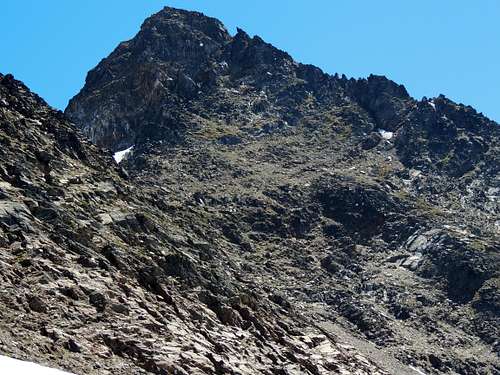
Clark's west face
Start by seeing Klenke’s excellent write up of this mountain. From the summit, descend the west face. I ascended this first, so it does work, but approaching blind from above might seem intimidating. From the summit scramble down southward a hundred feet, then start looking down the slots on the west face. A rope for a short rappel would be very comforting here, but is not critical for the more agile (I liked having one here). Lots of loose dirt and rock on the steep slope just below the summit structure, advise caution, a group should stick close or avoid traveling under each other.
Once down to more easily scrambled terrain, descend to the high basin and pick your preference, traverse the south side over to Luahna’s southwest face, or traverse around or go over point 7970 and then onto the upper Richardson Glacier, to access the possible speculative southeast side route described at the end of this page.
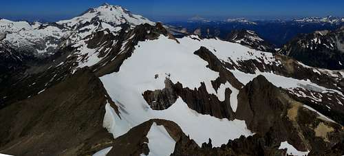
Luahna Peak viewed from the summit of Clark. One can see possible SE side routes here.
The climb via southwest face (and other speculations)
Southwest slope of Luahna
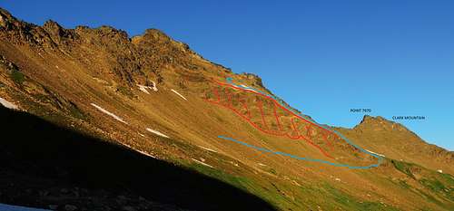
Southwest slope of Luahna - annotated
There is a slanting buttress, cliff, fold, or rumple (not sure what to call it) running due south from the summit area which presents something of an obstacle if coming from the west, such as by the Pilz Glacier pass west of Luahna. If so, I would suggest to round the toe of this buttress section at about 7200 feet. I’ve included an annotated version of the photo of Luahna’s southwest face to hopefully make this a little clearer. If coming from the south, like from Clark, this cliff won’t be an issue. Then it is just a matter of tolerating some loose rock and dirt as you ascend generally north toward the summit structure.
The slope naturally sends you ascending leftward (The blue line in the annotated version of the photo of Luahna’s southwest face). There are some grit-covered rounded slabs or bulges, but these can be managed with caution. At the final summit area, you may be dismayed to see lots of vertical rock leaning above you. Fear not and keep trending left as you ascend along the base of these cliffs. You will come to a nearly vertical step about ten feet high composed of very dark rock; to your left spot the foot wide band of almost white rock, a vertical dike in the middle of this darker rock. That provides some easier holds to climb up and over the step. Then just follow the obvious steep dirty ramp that now comes into view to the left, it goes behind a largish tower that actually forms a corridor for a short bit, this will take you right to the summit. This last bit is actually sort of surprising and entertaining because of how unexpected it is.
It also appears a southeast side climb would feasible, maybe even easier than the southwest face, by coming from the upper end of the Richardson Glacier which smoothly runs up against the rock on the north side. The upper end of the Richardson can be accessed quite easily from the low spot between Luahna and point 7970, just northwest of Clark. But I only looked at the upper part of the rock on the SE face from the summit, so saying it looks easy is pure speculation. There were some fresh goat tracks in a patch of snow high on this face, so they appear to like it.
There are a few trip reports on line indicating an ascent directly from the Pilz Glacier pass is feasible using ledges. An ascent directly from an eastern arm of the the Pilz Glacier would involve very steep snow or ice.