
-
 10915 Hits
-
 82.69% Score
-
 16 Votes
|
|
Mountain/Rock |
|---|---|
|
|
47.93859°N / 121.05994°W |
|
|
Chelan |
|
|
Hiking, Mountaineering |
|
|
Spring, Summer, Fall |
|
|
6577 ft / 2005 m |
|
|
Overview
 Longfellow East Face
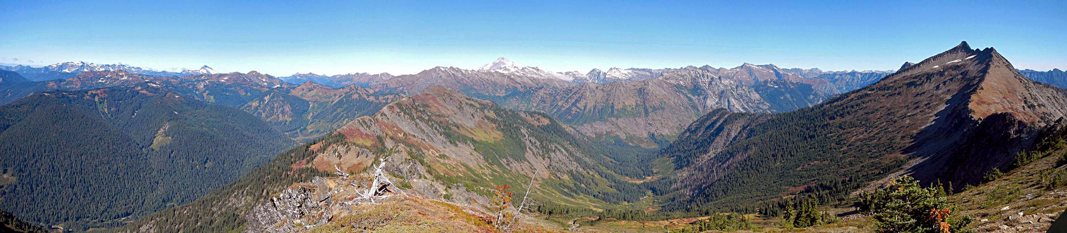
Longfellow Mountain is located central among the poet peaks of "Poets Ridge", 12 miles northwest of Lake Wenatchee. The ridge is officially named Wenatchee Ridge, but it is known as "Poets Ridge" since seven of the peaks are named after famous poets.
 The Summit Block Seen From The South
Longfellow has three main ridges separated by three different drainage basins. The northwest ridge extends to connect with Bryant Peak. The northeast ridge joins with Whittier Peak and two more poet peaks are further on in that direction, Mount Jonathan and Mount David. The south ridge, which is the standard approach route, extends to Poe Mountain and further to Irving Peak. These are the seven poet peaks. They range in difficulty and accessibility with Whittier and Jonathan being more difficult and more remote.
 |
Longfellow mountain is seldom climbed as the sole destination. With the exception of Poe Mountain, trips to "Poets Ridge" often combine multiple summits. Longfellow can easily be combined with Poe but it is also possible to add on either Whittier or Bryant for a very long day. Overnight trips are an option but depending on the time of year, it's a good idea to carry extra water. One place water can be found, even in late summer or fall, is in the rocky basin on the northeast face of Longfellow. Here, melting snow patches tend to linger. These small trickles turn into Papoose Creek which flows into Indian Creek.
So who was Longfellow and what about the other poets?
Henry Wadsworth Longfellow
 Fall Colors On Longfellow
Henry Wadsworth Longfellow was an American poet who lived from 1807 to 1882. He is most famous for his poem Paul Revere's Ride which eventually turned from folklore to legend, taking it's place among other well known Civil War stories despite it's historical inaccuracies.
Longfellow was one of the five "Fireside Poets" who were the first American poets to gain widespread popularity and fame. Notably, two of the other fireside poets are also represented with named summits on Wenatchee Ridge. All the poets represented on "Poets Ridge" were American poets who gained popularity in the early 19th century, with the exception of one.
The Odd Man Out: Jonathan Swift
Jonathan Swift was born an Irishman in the 17th century. There's no doubt about his poetic talent, but why was he included among the Poets of poets ridge? Good question. Perhaps it is fitting that at the time of this writing Jonathan Mountain is the only peak left without a SummitPost page. See the links below for more information on these poets.

Standard Route
In essence, the standard route follows the ridge trail from Poe Mountain and then traverses around the west side of the summit block to gain the northwest ridge for the finish. The Trail North Of Poe Mountain
There are two trailheads which can be used for the approach. The Poe Mountain trail is the shortest, but involves an extra 1250 feet of elevation gain. For this reason many will choose to use the slightly longer Irving Pass trail. Either way, the first objective is to go to the summit of Poe Mountain. From there, follow the trail north as it stays on or near the top of ridge.
 Whittier Peak With The Distinctive West Ridge
This trail does not appear on many maps. Several maps indicate that there is no trail along the ridge between the Poe Mountain and Bryant Peak, but this is only half truth. In fact most of the way between Bryant and Poe is well established and easy to follow with the exception of a short section in the vicinity of Longfellow. But there is no trail to the summit of Longfellow. To reach the summit requires route finding skills and navigation experience on class 2 terrain.
 The Section Of Trail Which Has Faded Away
North of Poe Mountain the trail passes several high points before traversing under the summit block of Longfellow. Just west of Point 6540 the trail enters a broad flat area with good spots for camping. North of there the trail fades away for a few hundred yards before becoming well defined again on its way to Bryant. It's possible to access the upper northwest ridge by ascending directly uphill from the bowl located northwest of Point 6540. This way becomes steep and a few class 3 moves can be expected.
 Class 2 Terrain Near The Summit
An alternative, which is longer but probably easier, is to follow the standard route for Whittier Peak as it crosses over the northwest ridge and leads to the upper north face of Longfellow. From the upper north face, ascend directly south on snow or slabs covered with loose rocks and dirt. There are some steep grassy slopes where you drop down from the northwest ridge at 5860 feet, but this option should not exceed class 2.
Red Tape / When To Climb
It's possible to climb this peak Spring through Fall, but expect a lot of lingering snow on the route until July. If you have any doubts, bring your ice axe.A northwest forest pass is required to park at either trailhead.
Driving Directions
Why reinvent the wheel? The following directions were taken from the Poe Mountain page, written up by my friend, SummitPost member Redwic. Thanks Craig! "Poet's Ridge" Seen From West Cady Ridge
Driving Directions to Irving Pass Trailhead (Trail #1545), westbound from Leavenworth:
1) From Leavenworth, follow Highway 2 westbound for 15.3 miles to Highway 207 (approximately MilePost 84.7).
2) Head north (right) on Highway 207.
3) After 11.5 miles, continue straight through a gate. This is the beginning of Forest Road 65 (FR-6500). An “End of County Road” sign is located at the gate.
4) After 7.0 miles, turn right onto an unpaved/ unmarked road. This is the beginning of FR-6504.*
5) Follow FR-6504 for 6.1 miles to the trailhead/ end of the road.
*NOTE: An alternate route to FR-6504 is to continue on FR-6500 for 3.8 miles beyond the first FR-6504 turnoff, to where the pavement ends, and then turn right onto an unpaved/ unmarked road. After 1.3 miles, the road meets FR-6504 at a “T” intersection. Turn left onto FR-6504 and follow 3.1 miles to the trailhead/ end of the road.
Driving Directions to Irving Pass Trailhead (Trail #1545), eastbound from Stevens Pass:
1) From Stevens Pass, follow Highway 2 eastbound for 4.0 miles (approximately MilePost 68.6).
2) Turn left and cross the (divided) highway onto Forest Road 67 (FR-6700).
3) Follow FR-6700 for 12.6 miles to its end, at the intersection with FR-6500.
4) Turn left onto FR-6500.
5) After 2.3 miles, turn right onto an unpaved/ unmarked road. This is the beginning of FR-6504.*
6) Follow FR-6504 for 6.1 miles to the trailhead/ end of the road.
*NOTE: An alternate route to FR-6504 is to continue on FR-6500 for 3.8 miles beyond the first FR-6504 turnoff, to where the pavement ends, and then turn right onto an unpaved/ unmarked road. After 1.3 miles, the road meets FR-6504 at a “T” intersection. Turn left onto FR-6504 and follow 3.1 miles to the trailhead/ end of the road.
 Longfellow Mountain And Fall Colors
Driving Directions to Poe Mountain Trailhead (Trail #1520), westbound from Leavenworth:
1) From Leavenworth, follow Highway 2 westbound for approximately 15.3 miles to Highway 207 (approximately MilePost 84.7).
2) Head north (right) on Highway 207.
3) After 11.5 miles, continue straight through a gate. This is the beginning of Forest Road 65 (FR-6500). An “End of County Road” sign is located at the gate.
4) After 13.5 miles, FR-6500 ends at the parking lot for Little Wenatchee Ford Campground, Little Wenatchee Trail #1525, and Poe Mountain Trail #1520.
Driving Directions to Poe Mountain Trailhead (Trail #1520), eastbound from Stevens Pass:
1) From Stevens Pass, follow Highway 2 eastbound for 4.0 miles (approximately MilePost 68.6).
2) Turn left and cross the (divided) highway onto Forest Road 67 (FR-6700).
3) Follow FR-6700 for 12.6 miles to its end, at the intersection with FR-6500.
4) Turn left onto FR-6500.
5) After 6.5 miles, FR-6500 ends at the parking lot for Little Wenatchee Ford Campground, Little Wenatchee Trail #1525, and Poe Mountain Trail #1520.