
|
|
Mountain/Rock |
|---|---|
|
|
47.36621°N / 121.16132°W |
|
|
Kittitas |
|
|
Hiking |
|
|
Spring, Summer, Fall, Winter |
|
|
5203 ft / 1586 m |
|
|
Overview
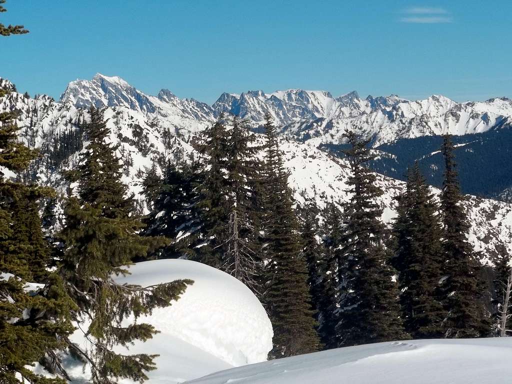 |
Fools Day Peak, located northwest of Lake Cle Elum is another decent winter summit destination in Washington State. The name “Fools Day Peak” is technically unofficial but it should be note that the peak is noted to have just over 400 feet of prominence. Though this mountain can be done easily in summer, winter is the primary time that this peak is attempted. The mountain itself is mostly wooded on all sides all the way up to the final summit ridge. The final summit ridge though is mostly open leading to partial views in all directions and excellent views of French Cabin Peak to the south and Mount Rainier towering above it many miles to the south. The summit ridge also has good views of Red Mountain, Mount Stuart and the Enchantment Range to the north.
 The final summit ridge The final summit ridge |  Decent views to the Cascade Crest Decent views to the Cascade Crest |
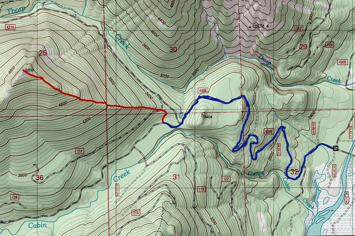
In winter this is a 10 mile long snowshoe requiring 3000 feet of elevation gain. Usually this is a single summit effort that requires 6-8 hours of work depending of conditioning and people. The route up this peak is avalanche safe all the way to the summit ridge of this peak. There is a little risk right on the summit ridge but this mountain should in considerable avalanche danger days. If you can handle the occasional snowmobile exhaust from the snowmobiles that use the trail the first section of the hike up is groomed making it very fast to ascent. The second section makes up for the lack of challenge and exercise on the first section by requiring an wooded steeper snowshoe up the eastern ridge of Fools Day Peak.
In summer this summit is not usually the primary destination trip. Personally one would have to be foolish to only go for this summit when Hard Knox and Thorp Mountain are located so close-by. Therefore this peak is usually just another summit on a peak-bagging trip and in summertime only visited by peak-baggers as a list add . Ascending this summit requires about three hours maximum and depending on the condition of Forest Road 125 it will require 1400 feet max elevation gain. The last little bit to the summit is off-trail and Class 2 at worse.
Getting There
VIA THE FRENCH CABIN SNOPARK: Get off on exit 80 toward Salmon La Sac/Roslyn and head north onto Bullfrog Rd for 2 miles. On the first traffic circle, continue straight to stay on Bullfrog Rd as you pass Suncadia Resort. Just 3/4 mile further lies a second traffic circle. Get onto WA-903 N until in the town of Roslyn. Make a brief left onto W Nevada Ave then another right on 7th St which will be WA-903 N. The road will turn into Salmon La Sac Rd and the cobined distance to your next turn will be 12.5 miles. You then turn on NF-4308 which will lead you to the French Cabin SnoPark.SUMMER DIRECTIONS: Stay on NF-4308 for 3.2 miles. Make a right on NF-4312 and take it to a dirt road on the left. Trailhead parking will be 2.8 miles. The dirt road be your route up the mountain in summer.
Route
 |
Winter Route "Recommended"
 Our group heading up the mountain
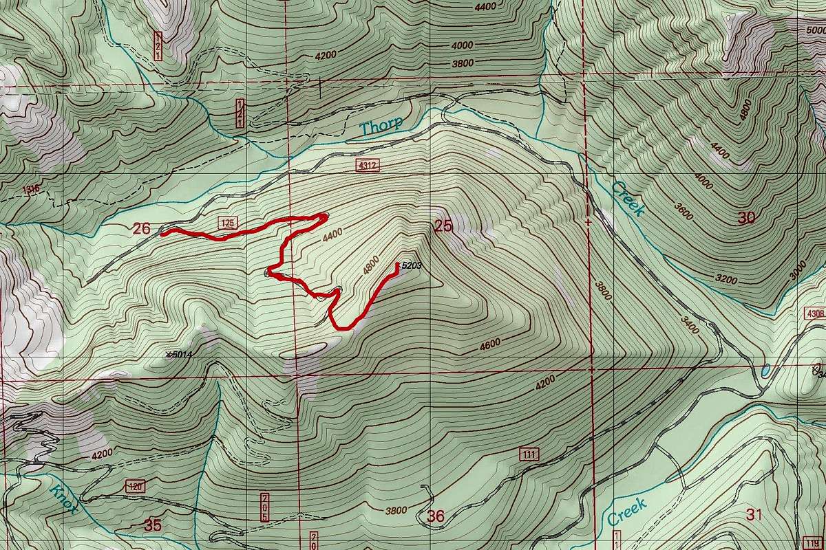 |
Summer Route
This is the recommended summer route. Due to the nature of the forest roads in the region it should be assumed that Forest Road 125 is probably not good condition suited for car travel. Assume that is the case and walk up forest road 125 all of the way to the end. From there bushwhack all the way to the ridgeline. From there make a left and walk up the ridgeline all of the way to the summit of Fools Day Peak.
Red Tape
In summer a National Forest Pass ($5 for the day or $30 for the year) is required and can be purchased at an ranger station or at REI.In winter a Sno-Park pass is required which is $21 for the day and $42 for the year.
When to Climb
Personally I would recommend doing this peak in winter. It is far more of a workout and much more desirable in winter when many larger mountains in the region are snowed in. This range of mountains tends to be warmer on hot summer days due to its proximity to the Teanaway Region and eastern Washington. Temperatures in the 90's are quiet common on the valleys and heat waves can occur yearly here. I think the value of this summit would be quiet low considering all the other higher mountains that surround it. If you do choose to climb this mountain in summer combine with one of the other mountains in the region.Camping
Personally I did not see any desirable camping areas or bivy areas right on Fools Day Peak. However on nearby trails there were a number of areas that could be desirable for camping. If you camp here remember to leave no trace.External Links
A cross country ski trip to the summit of Fools Day PeakThe Peakbagger home page for Fools Day Peak
Fools Day Peak on a Stormy Day