
-
 15227 Hits
-
 83.74% Score
-
 18 Votes
|
|
Mountain/Rock |
|---|---|
|
|
37.99547°N / 105.56061°W |
|
|
Download GPX » View Route on Map |
|
|
Custer |
|
|
Hiking |
|
|
Spring, Summer, Fall, Winter |
|
|
13705 ft / 4177 m |
|
|
Overview
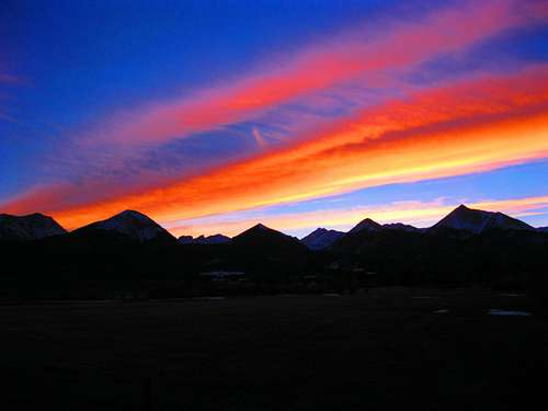
Fiery Sangre Sunset! (L-R): Humboldt Pk, Colony Baldy, Columbia PT, Kit Carson Peak, Challenger PT, Little Baldy, Mt Adams, Little Horn, Fluted Pk, Horn Pk.
Colony Baldy is located very close to, and is thus overshadowed by, the very popular "Fourteeners" Humboldt Peak, Crestone Peak, Crestone Needle, Kit Carson and Challenger Point and sees only a small fraction of the ascents that they do. Another factor that causes Colony Baldy's lack of visits is access. Due to private land below it's Northeast ridge, access to Colony Baldy is not nearly as convenient as these other peaks. One must hike along the Rainbow Trail for 3.5mi from the nearest trail head before reaching the Northeast ridge of Colony Baldy. Despite these issues, a climb of Colony Baldy is a very worthwhile endeavor due to the spectacular, unobstructed, and very unique views the summit gives you of the peaks mentioned above and also of nearby 13,931' Mount Adams. You will enjoy classic Sangre solitude with jaw-dropping vistas while the masses clamber up the nearby fourteeners. ![Colony Baldy]()
For Sangre lovers, a familiar skyline of shapely peaks from a field off of road 129. You can see the massive spin drift blowing from Colony Baldy towards Humboldt. The Peaks shown are(from left to right): Humboldt Peak (14,065), Colony Baldy (13,705), Little Baldy (12,982), Little Horn (13,143), and Horn Peak (13,450).
Route
![Colony Baldy - East Ridge Route]()
Map of East Ridge RouteThe Normal Route for Colony Baldy is an easy Class 1-2 (12mi, 4800' elev gain) climb via the Northeast Ridge. Starting from the Horn Creek TH hike 1/2 mile SW until you intersect the Rainbow Trail. Turn Left, cross Horn Creek and follow the Rainbow Trail for ~3 miles gaining 1000ft along the way as it weaves in and out of 4 small drainages until you come to the Macey Lakes Trail. This intersection is signed.
Getting There
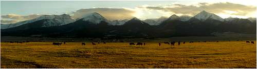
For Sangre lovers, a familiar skyline of shapely peaks from a field off of road 129. You can see the massive spin drift blowing from Colony Baldy towards Humboldt. The Peaks shown are(from left to right): Humboldt Peak (14,065), Colony Baldy (13,705), Little Baldy (12,982), Little Horn (13,143), and Horn Peak (13,450).
Colony Baldy is best accessed from the Horn Creek Trailhead near Westcliffe, CO.
From the CO96/CO69 junction in Westcliffe Google Maps Driving Instructions
Drive south on CO69 3.4mi and turn RIGHT onto Schoolfield Road/County Road 140. There will be signs for "Rosita Rd" as you get closer to the junction. Rosita Rd is to the left and Schoolfield Rd/Co Rd 140 is to the right.
Travel west on Schoolfield/Co Rd 140 for 1.8mi to Macey Ln/Co Rd 129. At this junction you will see signs for the Horn Creek TH. Turn LEFT.
Drive South on Macey Ln/Co Rd 129 for 2.0mi until you come to Horn Rd/Co Rd 130 and turn RIGHT. There will be a National Forest sign here pointing right for the Horn Creek TH.
Follow Horn Rd west up the hill towards the mountains. Stay on the main/paved road as it makes a turn to the left and then to the right. After this right turn you will see a sign for the Horn Creek Ranch.
Bear RIGHT at this entrance and follow the road until you get to the Horn Creek TH. In Winter the road is plowed up until .25mi of the TH where the pavement ends.
Route
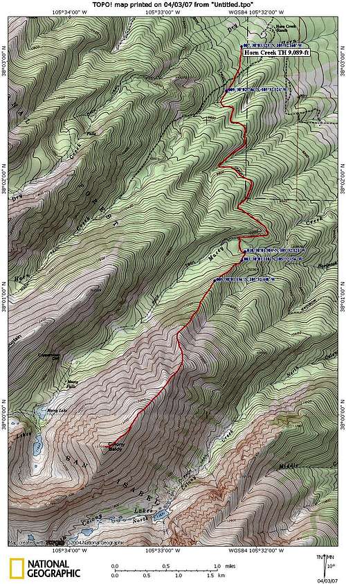
Map of East Ridge Route
From this junction cross the bridge and continue south on the Rainbow Trail 1/4mi until you come to the point of the Northeast Ridge. Leave the trail and head west up through the trees staying on the crest of the Northeast Ridge. You have 1.2mi and ~1500' to gain before you reach treeline. The last 500' before you reach treeline is quite steep. At around 11,000' you can also traverse left and leave the trees earlier and proceed up grassy slopes.
Once above treeline continue up the steep and broad tundra slope to ~12,900'. From here the slope mellows and you have several false summits to climb over before reaching the true summit of Colony Baldy.
Garratt and Martin, in their High Thirteeners book, describe a route from the Macey Lakes Basin. Hike up to Macey Lakes via the Macey Lakes Trail and leave the SW Macey Lake and climb up steep tundra to Colony Baldy's summit. This route is 7mi longer than the Northeast Ridge Route at 19mi, but Garratt and Martin says there is good camping in the Macey Lakes Basin.
![Colony Baldy from Rainbow Trail]()
Colony Baldy from Rainbow Trail. March 30, 2013Colony Baldy is located within the Sangre De Cristo Wilderness of the San Isabel National Forest. Please observe all standard Wilderness Regulations and strive to leave the Wilderness as pristine as you found it. Contacting the managing agencies (see 'Mountain Conditions') is the surest way to get up-to-date information.
Leave No Trace suggests you observe these principles when traveling and camping in all public lands, especially wilderness:
1. Plan Ahead and Prepare
2. Travel and Camp on Durable Surfaces
3. Dispose of Waste Properly
4. Leave What You Find
5. Minimize Campfire Impacts
6. Respect Wildlife
7. Be Considerate of Other Visitors
Red Tape
Colony Baldy from Rainbow Trail. March 30, 2013
Leave No Trace suggests you observe these principles when traveling and camping in all public lands, especially wilderness:
1. Plan Ahead and Prepare
2. Travel and Camp on Durable Surfaces
3. Dispose of Waste Properly
4. Leave What You Find
5. Minimize Campfire Impacts
6. Respect Wildlife
7. Be Considerate of Other Visitors
Also, Colony Baldy can only be accessed via the Rainbow Trail. There is extensive private land to to the east of the Rainbow Trail. Please DO NOT trespass on private property while attempting to access the Northeast Ridge, the Rainbow Trail is quite pleasant and will get you the Northeast Ridge very quickly.
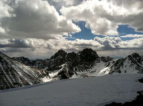
![Crestone Peaks Viewed from Colony Baldy]() Crestone Peaks viewed from Colony Baldy Mar 30,2013Colony Baldy can be climbed year round. Best time is from May-October after the snow pack melts and before snow makes the approach through the trees more arduous. This peak is still a worthy Winter goal and the vista of the snow-covered peaks in the surrounding area will make the extra effort quite worth it.
Crestone Peaks viewed from Colony Baldy Mar 30,2013Colony Baldy can be climbed year round. Best time is from May-October after the snow pack melts and before snow makes the approach through the trees more arduous. This peak is still a worthy Winter goal and the vista of the snow-covered peaks in the surrounding area will make the extra effort quite worth it.
When to Climb
 Crestone Peaks viewed from Colony Baldy Mar 30,2013
In Summer keep a close eye on weather conditions as thunderstorms will form over the range crest to your West and Colony Baldy will block your view of any thunderstorms that are forming. Plus, once up on the summit ridge you are quite a ways from treeline and are very exposed to lightning.
In Winter, once you are above treeline the tundra is usually wind-blown making snowshoes, microspikes, and crampons unnecessary there. But, always beware of avalanche danger while climbing this peak and avoid cornices on the south side of the Northeast ridge.![Frozen Macey Lakes]()
Looking down in the valley south of Little Baldy Mountain. One of Macey Lakes is frozen over. Colony Baldy and Humboldt Peaks rise high above the valley floor.Camping at the Horn Creek TH is available. Off-trail camping before you reach treeline is available too but be sure to respect the wilderness and follow LNT principles. If you are climbing Colony Baldy via Macey Lakes, the route suggested by Garratt and Martin, they say there is good camping near the lakes.
Camping
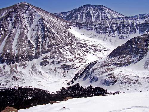
Looking down in the valley south of Little Baldy Mountain. One of Macey Lakes is frozen over. Colony Baldy and Humboldt Peaks rise high above the valley floor.
External Links
Colony Baldy Trip Report by Kane