
-
 8671 Hits
-
 78.85% Score
-
 10 Votes
|
|
Mountain/Rock |
|---|---|
|
|
35.09282°N / 25.47123°E |
|
|
Download GPX » View Route on Map |
|
|
Hiking |
|
|
Spring, Summer, Fall |
|
|
7024 ft / 2141 m |
|
|
Overview
 Afentis Christos north face |
Αφέντης Χριστός / Afentis Christos (Lord Christ) is the second highest mountain of Crete's third highest mountain range, the Dikti Range, which is located in the east of the island, right to the west of its narrowest section. The range is more than 2000m high and with Dikti / Spathi and Afentis Christos it has two main mountains, which are almost equal in height. The third 2000er is Lazaros (2085m), east of the two.
Afentis Christos is a broad backed massif, consisting of a multitude of summits, all above 2000m. The main summit is to the south-west of the massif, hidden from sight. Like so many of Crete's mountains it carries a summit chapel (likewise called Afentis Christos), which often serves as a shelter from the high winds which can sweep the island. To the north the mountain drops with an impressive face for several 100m while on all other sides smooth slopes dominate. A long streched ridge of unnamed summits leads from the summit towards the east near the hamlet Selakano, a ridge which dominates the aspect of the whole range when seen from the south.
 |  |  |
Ascent routes to the Afentis Christos main summit are all rather long and guidebooks claim that the mountain is the remotest oand most difficult mountain on Crete. It is remote for sure but the normal route is a mere hike which requires some skills in orientation on karst terrain. The mountain is made up from grey limestone and shows the typical karst phenomena like dolines, plateaus and even caves.
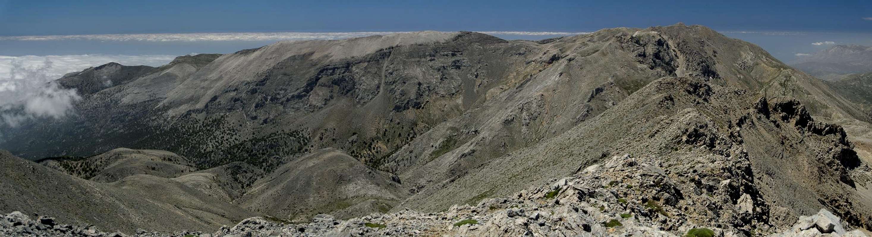
Afentis Christos Massif seen from Dikti
There are two main routes which join forces for the actual ascent and which are connected by Crete's long distance trekking trail E4. The shortest route starts in the north on the Limnakarou Plateau above the Lasithi Plain and climbs to the saddle which separates Afentis Christos from Dikti / Spathi. The other route starts at Selakano in the east and heads up to the same saddle. From there both routes combine and follow the north-east ridge of the mountain, always staying some 100m beneath it on the eastern side. It circumvents several false summits before heading up the final summit cone without a path.
 |  |  |
There is also a route starting from Kato Simi in the south-west of the mountain, which starts as a traverse and finally climbs the mountain from the south-west directly. Views from the summit are not as impressive as from neighbouring Dikti / Spathi as much of the vista is hidden by the false summits. Also, looking into the huge north face is not possible from the remote summit. Rather hike to one of the saddles between the summits. In summer Afentis Christos is very popular as intense heat often drives Crete's visitors into the mountains. Still it can be very hot on the summit itself, especially when the wind is headed from Sahara in the south. It often carries a lot of dust which greatly restricts visibility.
Summit Panorama
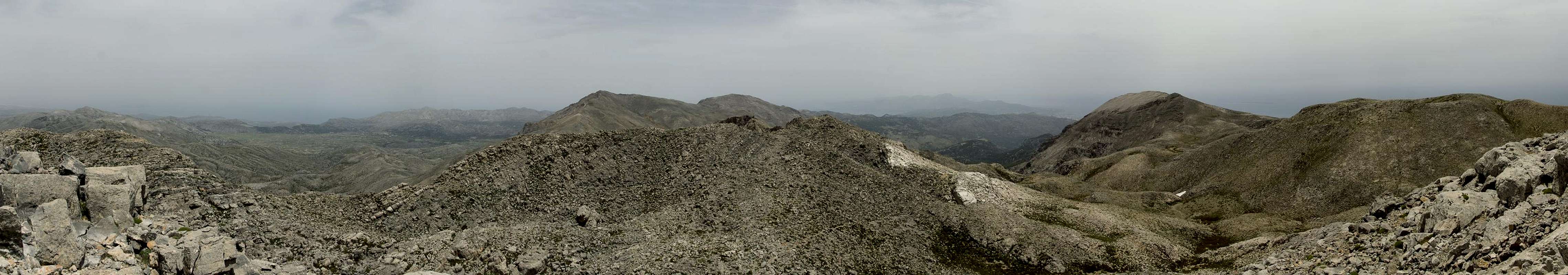
Summit panorama to the north and east
Getting There
There are two international airports on Crete, both in the north of the island. One is at Chania in the west, the other is at Heraklion in the centre.There are myriads of ferries in Greece, which connect the many islands of the country. Consequently there are many ferry harbours and Crete is no exception. However, most of the smaller harbours only cater for transportation to the other islands while the major lines to the mainland are reserved to two harbours, Souda near Chania and Heraklion. Both serve connections to Peiraias and Thessaloniki.
To reach the trailheads you need to follow highway no 90 east from Heraklion.
- For the Lasithi Plateau leave the highway near Chersonisos and follow the signs for the Plateau. Once on the plateau, drive to Agios Georgios and Avrakontes, where a small mountain road heads up to the Limnakarou Plateau.
- For Selakano drive highway 90 to Pachia Ammos, where you turn on the road to Ierapetra. Here turn west again to Mirtos, where you switch to the road to Males (in Mournies you can turn west for the third trailhead at Kato Simi). In Males, follow the dead end road to Christos but before you reach the village the narrow road to Selakano turns off to the right.
Red Tape
 Happy Sheep Family
There is no red tape but respect the farmers on the Lasithi and Limnakarou plateaus. There also are huge flocks of sheep and goats which often are fenced in. Close gates or wherever you have to climb a fence make sure that it still stands upright afterwards.
Accommodation
You can quite easily find hotel rooms and apartments everywhere on the coasts. All European travel companies offer accommodation so a visit to your nearest travel office will find you some. In the mountain villages there always are inns and if everything fails you can pitch a tent.There are abundant campgrounds along the coast and on many of the beaches you can pitch your tent. The touristic beaches in the north and the beaches in the vicinity of tourist towns are mostly off-limits but there is many a cove which you can use. In the mountains you will often find cattle (goat and sheep) fences which you should respect. There is many a green meadow in one of the plains but you should be aware that you’ll be woken up by goats. Again, in the vicinity of villages, rather ask the locals if you can use their land.
Weather Conditions
Maps & Books
There are quite a number of maps and books out there, which deal with the island of Crete and naturally I don’t know them all. This is the list of maps and books which I used and I appreciate it very much if you can add to itMaps
Unfortunately there are no decent topographic maps of Crete. The best maps I could find are scaled 1:100000 and contain the main hiking routes on the island. In one case the map showed wrong paths and roads (exchanged them) but in general they were quite useful. In any case they were better than the Anvasi Maps, also scaled 1:100000, which claim to be topographic maps but miss routes and even mountains
- Kreta / Crete / ΚΡΗΤΗ Western Part
Touring Map
1:100000
Harms Verlag
ISBN: 3-927468-16-9
- Kreta / Crete / ΚΡΗΤΗ Eastern Part
Touring Map
1:100000
Harms Verlag
ISBN: 3-927468-17-7
Books
Since there are no good topographical maps of Crete you should take care to get a good guidebook. The ones I used have good tour suggestions though the descriptions often are somewhat shortish and can be misleading. The books are available in German and English.
- Kreta Ost / Crete East
Gert Hirner / Jakob Murböck (translation: Gill Round)
Rother Verlag
ISBN:
978-3-7633-4004-0 (German)
978-3-7633-4822-0 (English)