
-
 15780 Hits
-
 84.32% Score
-
 19 Votes
|
|
Mountain/Rock |
|---|---|
|
|
45.16406°N / 109.60459°W |
|
|
Hiking, Mountaineering, Trad Climbing, Big Wall, Scrambling, Skiing |
|
|
Spring, Summer, Fall, Winter |
|
|
11935 ft / 3638 m |
|
|
Overview
Sylvan Peak stands proudly as the first peak you see when driving into the East Rosebud drainage. At 11,935 feet in elevation, it falls just short of having the 12er designation. The summit of Sylvan Peak is hardly talked about however as all the glory goes to the endless granite cliffs and walls flanking just about every side of the peak. To the west, the East Rosebud Plateau drops very steeply into the East Rosebud drainage. These walls offer some great trad climbing opportunities as well as challenging aid climbs. On the east side it drops into Hellroaring Creek where Crow lake is located. This creek drains into East Rosebud Creek downstream of the trailheads. The only real easy ways to reach Sylvan Peak are from the north or the south. The Sylvan Peak Mountain Shop in Red Lodge is named after the peak and is a fantastic place meet some local Beartooth Mountain climbers.
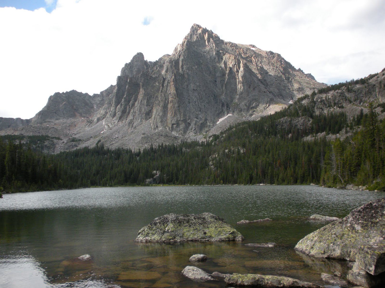
Sylvan Peak and its west faces from Crow Lake
Getting There
I will describe the easiest route up Sylvan Peak here which is accessed via the East Rosebud Trailhead. There are a handful of very difficult rock climbing routes on the faces surrounding the peak but until I do any of them, I cannot say much about them.
East Rosebud Trailhead - From the MT 308 and US 212 junction at the south end of Red Lodge, head north on US Highway 212 for 1.5 miles and turn left onto MT State Highway 78. After 19.7 miles reach Roscoe and make a sharp left onto East Rosebud Road and measure from this point. After 0.2 mile, pass by the Grizzly Bar and restaurant and continue another 2.4 miles where the road turns to gravel. At mile 3.7, make a left onto the East Rosebud Lake Road and quickly cross East Rosebud Creek on a bridge. Just after the crossing, make a right on East Rosebud Lake Road and cross a cattle guard. At mile 8.3 enter the Custer National Forest where the road becomes paved again and now becomes FS Road 2177. Pass the Jimmy Joe Campground at mile 11.9 where it turns to dirt once again. Pass the Phantom Creek trailhead at mile 13.6 and continue another 3/4 mile to the turnoff for the East Rosebud campground. Drive a short ways to the end of the campground and park at the signed trailhead which is at 6,400 feet elevation.
Route - North Slopes
Begin hiking up the East Rosebud/Senia Trail as it ascends along Spread Creek until 6,900 feet elevation. The trail then starts a series of 8 long but mellow grade switchbacks as it climbs high above Spread Creek. At about 8,500 feet, three miles from the trailhead, the trail crosses the south fork of Spread Creek on a few placed logs. Instead of crossing the creek, leave the trail and follow the creek up to 8,600 feet, then bushwhack a bit towards the southwest to the start of a large burn area at 8,700 feet. Shortly beyond is a flat bench to hike across and begin hiking steeply up through the burn area in a SW direction. Continue up and begin veering left. You will emerge above the last of the burned trees at 9,400 feet, and reach treeline at 9,800 feet, 0.7 mile from the trail. Continue south up the hill another 0.8 miles as the slope gradually mellows and reach a flat bench at 10,500 feet with a couple 30 foot rock outcroppings nearby. Beyond this point you are fully exposed to the elements for the remaining 1.4 mile hike to the south and southeast up the gentle plateau to the summit. In summer the plateau is filled with beautiful wildflowers to enjoy. This peak can be climbed any time of year but early summer may be the best so you can enjoy these wildflowers. Watch our for the afternoon thunderstorms though. Winter brings lots and lots of cold and wind on the plateaus.
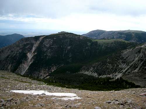 Looking down into Spread Creek from the north slopes of Sylvan Peak | 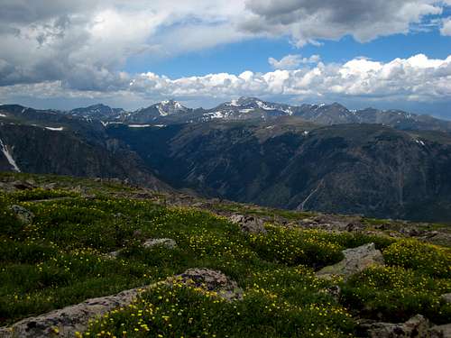 View northwest towards the Mount Wood Group from the north slopes of Sylvan Peak | 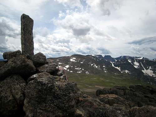 Looking south towards Bowback Mountain and Castle Mountain from the summit |
Map
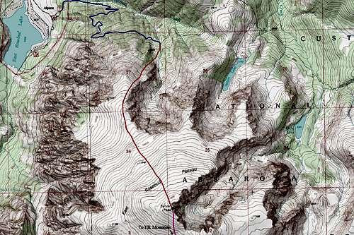
BLUE: East Rosebud/Senia Trail - Class 1
RED: Sylvan Peak North Slopes Route - Class 2
PINK: Sylvan Peak/Elk Mountain Traverse - Class 1+
Camping/Red Tape
This climb is best done as a day hike since there are no good camping opportunities on the route itself. Camping is available at the East Rosebud campground right next to the trailhead however this does have a fee. This area is within the Abasorka-Beartooth Wilderness therefore no motorized travel, including but not limited to, cars, motorcycles, bicycles, hang gliders, airplanes, scooters, etc... is allowed.Please practice leave no trace practices and do not disturb wildlife. You are in grizzly bear country here so always carry bear spray, or a gun, or both for protection only if you are attacked. Report any bears you may have killed or injured to a ranger as a result of any defenses you may have taken. There is a ranger office right at the junction of US Highway 212 and the West Fork Road at the southern end of Red Lodge.
External Links
For a weather forecast for the peak, see THIS page
Beartooth Climbing - This is a great reference regarding rock climbs in the East Rosebud drainage