
-
 8759 Hits
-
 85.23% Score
-
 20 Votes
|
|
Mountain/Rock |
|---|---|
|
|
37.93403°N / 107.61239°W |
|
|
San Juan |
|
|
Hiking |
|
|
Spring, Summer, Fall, Winter |
|
|
13203 ft / 4024 m |
|
|
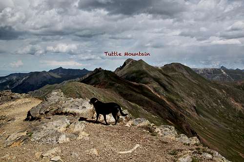
Overview
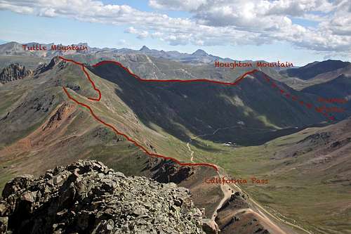
Overview of Tuttle and Houghton Mountains as seen from the summit of Hurricane Peak
The ridge from California Pass is technically very easy and offers excellent views in all directions. Most people tend to combine Tuttle Mountain with Houghton Mountain; both are located on the same ridge. Some add more peaks to their trip (I started at Hurricane Peak).
The whole area was explored in late 1800s and early 1900s by miners, and many remains of mining activity are still scattered on the slopes of Tuttle Mountain.
Animas Forks, one of the best preserved Colorado Ghost Towns, is located below the slopes of Houghton Mountain.
Colorado Rank: 486 does not make the mountain very popular destination
Line Parent: Hanson Peak
Class: 2
Scenery: beautiful in all directions
History: fun exploration of Animas Forks ghost town
Nearby Peaks: Houghton Mountain 1.48 miles
California Mountain A 1.32 miles
Hurricane Peak 1.42 miles
Brown Mountain A 1.66 miles
Hanson Peak 1.82 miles
Getting There
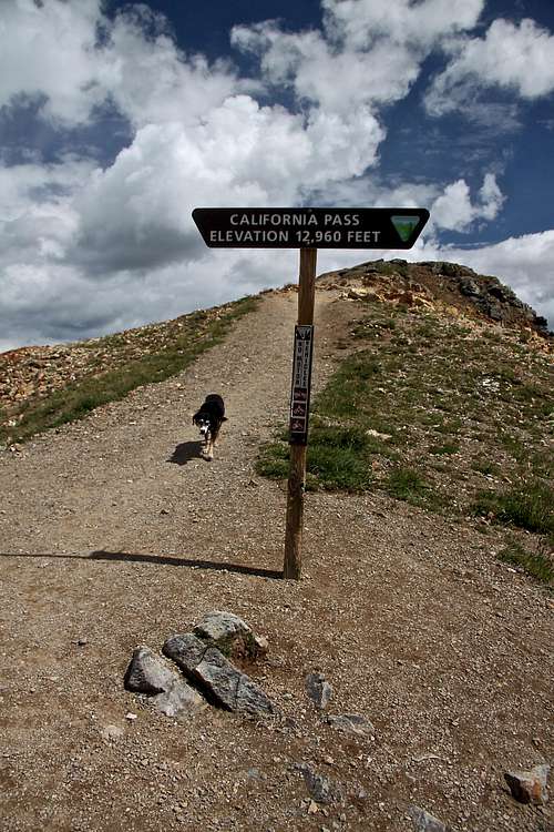
California Pass provides an excellent and high approach to Tuttle Mountain.
Tuttle Mountain (13,203') above Lake Como and Poughkeepsie Gulch 9-2007.
Please visit this website for more information.
I will describe the road from Silverton, which is a good dirt road and passable by 2WD vehicles. Again, even this road is closed during the winter.
Total Mileage from Silveton to Animas Forks is 12.1 miles, route elevation is from 9,400 feet to 11,370 feet. The road is well marked.
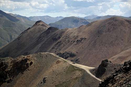
Head north from the town of Silverton onto Colorado 110, bear right. Pass campground at 0.4 miles. At 2 miles you pass Arrastra Gulch Trail and some mining buildings. At 4.0 miles you cross the bridge across the Animas River, at 4.2 miles you are at town site of Howardsville. At 7.7 miles you reach Eureka - the road is snowplowed to this point even in the winter (a very popular ice climbing destination). From here the road becomes slightly rougher (still passable by 2WD) and more narrow. You are going to pass turn off for Burns Gulch at ~ 10 miles. Burns Gulch provides access to three high 13ers in the area (American, Jones, and Niagara Peaks). Continue further north until you come to a well marked intersection - the more travelled road to the left leads to Animas Forks, which is visible from here, and the less travelled road to the right leads to Cinnamon Pass.
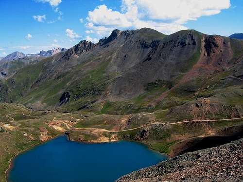
You can start your hike from the ghost town of Animas Forks. Houghton Mountain is nicely visible, or you can continue with your car to California Pass, elevation 12,960 feet. The road is relatively well maintained and is clearly marked. Just drive through Animas Forks and ascend to California Pass. From the pass, you look down onto Lake Como and Poughkeepsie Gulch, the road back to Animas Forks, and across to Hurricane Pass and Hurricane Peak.
You can either return the way you came with your vehicle, or you can continue with 4WD vehicle over Hurricane Pass back to Silverton.
Route
California Pass , elevation 12,960 feet
Tuttle Mountain as seen on the trail from California Pass.
I started at Hurricane Peak (see large photo in Overview section). The mentioned photo shows clearly the obvious path on the ridges with a few smaller summits before reaching the main summit of Tuttle Mountain. There is initially a nice trail, which eventually disappears, however cairns, and visible goal of your destination make route finding very easy. Most of the hike is class 1, towards the summit it becomes steeper and can be ranked as class 2. Northern slopes of Tuttle when descending towards Houghton Mountain are slightly steeper and have some scree.
You can either return from Tuttle back to California Pass, or you can continue over Houghton down to Animas Forks. The start at Animas Forks would mean a higher elevation change (~ 1880 feet gain).
 Slopes of Tuttle Mountain with Hurricane Peak in the background |  Duchess between Tuttle and Houghton Mountain | 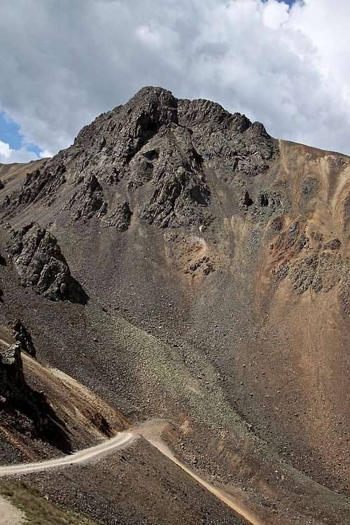 Hurricane Peak as seen from California Pass |
Animas Forks
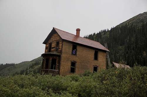
The famous Walsh House at Animas Forks.
In 1877, Otto Mears constructed a wagon road to Eureka and through to Silverton. This resulted in his network of toll roads connecting Lake City, Ouray, and Silverton. Animas Forks became the central junction for these and other roads that connected area's many mining camps.
Snow presented a huge problem for Animas Forks. Although the town was considered a year round mining community, the population dropped in the wintertime. In 1884, the population reached 400 in the summer but dropped to a dozen of men, three women, and 20 dogs in the winter. A winter storm that same year lasted for 23 days.
During the 1880s, telephone lines were installed, running from Lake City and passing over the 12,500 foot Continental Divide near Engineer Pass. Stagecoaches ran daily from Lake City to Silverton via Engineer Pass.
Mrs. Eckard, the first woman in Animas Forks, ran an extremely popular boarding house. Eckard won the favor of the local miners by extending them credit. When one freeloader slipped out of town without settling his account for three months of lodging, a vigilante committee set out after him. They caught him in Silverton and threatened to lynch him. He paid up, and no further debts were reported.
At its peak Animas Forks was home to about 1,500 residents. Located at an elevation of 11,584 feet, it once boasted that it was the largest city in the world at this elevation. Its prosperity began to wane by the 1890s, and the town was nearly deserted by 1901. Animas Forks experienced a resurgence of activity between 1904 and 1916. From Colorado Trails by Peter Massey, Jeanne Wilson, and Angela Titus.
Red Tape
There are no fees for accessing this area. Parking and hiking are for free.When to Climb
The best time is when the roads are open: typically late May to late September. Winter means a long back country approach, typically an overnight trip and traveling through an avalanche zone. Be aware of dangerous Colorado snow pack and always check current avalanche conditions.Camping
Free camping in high country. Please try to respect private property signs. I slept many times just in my car while exploring the area (have not experienced any ghost activity at Animas Forks).There are developed campgrounds near Silverton and Eureka.