
-
 16433 Hits
-
 77.59% Score
-
 9 Votes
|
|
Mountain/Rock |
|---|---|
|
|
39.39488°N / 120.55767°W |
|
|
Nevada County |
|
|
Hiking, Scrambling, Skiing |
|
|
Spring, Summer, Fall, Winter |
|
|
8028 ft / 2447 m |
|
|
Overview
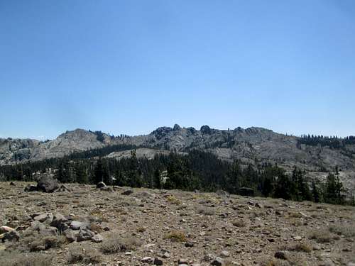
Black Buttes from Sand Hill Ridge, Tahoe National Forest.
The Black Buttes are a series of Northern Sierra basalt buttes atop a ridge in the scenic Grouse Ridge area north of Interstate 80, about 13 miles west of Donner Pass and 6 miles north of Cisco Grove. It ranks 57th on the Tahoe OGUL List. The highest point on the ridge is 8,028 feet atop the middle of the 3 main buttes, and can be seen easily from I-80 at Yuba Gap. The south aspect of the mountain consists of slopes of a temperate gradient, covered in manzanita. The northern aspect is very steep, with crumbly cliffs that plunge about 300 feet into the Glacier Lake area. Getting to the summit ridge requires just a tiny bit of cross-country hiking, but the summit butte is class 3. The rest of the buttes require class 2 scrambling in order to reach their summits. This area of the Tahoe National Forest consists of picturesque mixed granite and basalt mountains, the highest of which is Mount Lola. The views from the summit offer nice views of the peaks in the area, including the Sierra Buttes, Old Man Mountain, and English Mountain. The Black Buttes can be reached by a number of different routes, the most common being via The Glacier Lake Trail from the Grouse Ridge Trailhead. As accessible as the area is, expect to see some crowds on summer weekends. Approaches from Eagle Lakes Road or Baltimore Lake would be less crowded. Despite the possibility of crowds, this is a very nice area for hiking and backpacking. The peak can easily be done as a dayhike, or make for a nice overnight trip.
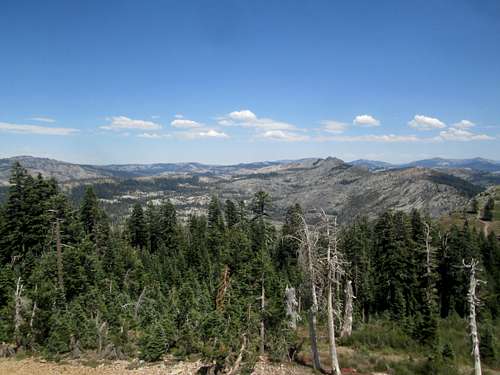
View east from the Grouse Ridge Lookout tower atop Grouse Ridge. The Black Buttes can be seen in the right-center of the photo.
Getting There
The most often used approach is from Grouse Ridge. From California Highway 20 6 miles west of I-80 and 23 miles east of Nevada City, turn north onto Bowman Lake Road and go 6.4 miles to Forest Route 14. Turn right on the unpaved FR 14 and drive about 5 miles to the Grouse Ridge Campground and trailhead. The road is passable in low clearance vehicles with careful driving. From here the Glacier Lake Trail leads to the Black Buttes (see below).
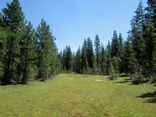
Wonderful meadow on the Glacier Lake Trail, near the junction with the Sand Hill Ridge trail.
The Glacier Lake Trail leaves from the trailhead at Grouse Ridge. From the parking lot, take the well signed Glacier Lake Trail about 5 miles to Glacier Lake, passing junctions for Milk Lake, Sand Hill Ridge, and Five Lakes. Once at Glacier Lake (many suitable campsites here), the summit will be visible about 300 feet above and to the right. Ascend the talus/scree slope on the right, following faint climber's paths. Once at the summit ridge, turn right (west) and crest the first butte. The highpoint is the next butte to the west. Climb a class 3 step on the southeast side of the butte. As of Summer 2013, there was no register at the summit.
There is a trail map of the area on the sign at the trailhead, but National Geographic Map Number 805 "Tahoe National Forest Sierra Buttes/Donner Pass" shows the trails in the area.
Red Tape
National Forest Rules apply here. A permit is required for use of fires, which can be obtained in Nevada City or Auburn.When to Climb
Like many peaks in this area, the Black Buttes get considerably more difficult to approach when FR 14 is gated, usually from November to June. Winter ascents would be most managable from Eagle Lakes Road, off I-80. See Bob Burd's trip report.Camping
There is a campground adjacent to the Grouse Ridge trailhead. Campsites are numerous and free. There is a vault toilet, but no water here, so be sure to pack enough in for car-camping trips.