
|
|
Mountain/Rock |
|---|---|
|
|
48.54522°N / 120.82379°W |
|
|
Mountaineering |
|
|
Summer |
|
|
8040 ft / 2451 m |
|
|
Overview
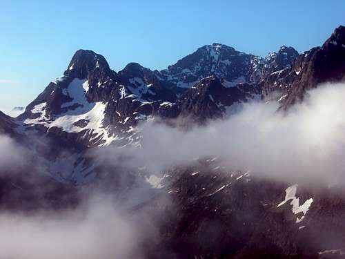
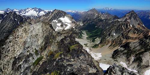
Fisher Peak to the left rises above the cloud deck. The west ridge, dotted with snow, extends down toward the center of the photo, and is highlighted between shadow and sun.
Fisher Peak is the tower at the east end of the Fisher Creek cirque, immediately east of the Silent Lakes and Mount Arriva. It is attractively shaped and positioned to draw the eye of anyone looking east from the crest of Easy Pass, with the green splendor of Fisher Creek meadows below and the ribbon of the creek leading upwards to a basin of rock and snow, the straight-line valley pointing directly at the mountain through a framing corridor of high rocky peaks. Because of this aesthetic, the climb gets a fair amount of traffic despite its modest altitude.
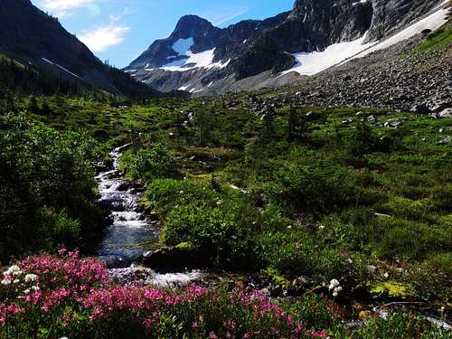
Fisher Peak rises above the green meadows of Fisher Creek
It may also get a fair amount of traffic because of it’s well-deserved reputation as a challenging and exposed but very fun scramble. Rock is sometimes excellent with bed dipping that favors boot and handholds, but in some places rock will break right off in your hand or large blocks will shift, so be warned.
There is also one step that may remove this climb from the “scramble” category and place it into the technical climb area. This is a judgment call on my part, but seeing as how writing this “guide” involves a level of responsibility, I don’t want to mislead anyone – there is considerable exposure on very steep rock in several places, and one step borders on 5.0… if there was a 4.9, that’s what I’d rate it.Getting There
Drive the North Cascades Highway, state route 20, 21.5 miles east from Colonial Creek Campground or 6.2 miles west from Rainy Pass to the Easy Pass Trailhead. Ample parking and restroom facilities.
Approach, first on trail, then cross-country: Walk the trail to Easy Pass, and behold one of the best on-trail views anywhere in the North Cascades National Park. Descend to the valley bottom on well-maintained trail. At the sign pointing west to the Fisher camp, instead of following the main trail, turn left (east). There is actually a boot-built trail going that way at first, but after about ten minutes of walking it disappears at a brushy pile of trees blown down by avalanches. This is a good place to then cross the creek and open marshy meadow to the south side of the valley; head straight across to the nearby talus slope to find drier ground, and then continue east. Once across, you’ll want to turn around and make a mental note of the spot, so on the return trip you’ll get across the marsh with the least boot soaking and be able to re-find the trail. In earlier season, often until mid-summer, snow bridges the creek and covers the marsh, eliminating this obstacle.
Then turn up valley and enjoy a relaxed off-trail ramble through some very pretty parklands, boulders, marmots, flowers, and abundant blueberries in late summer. At the valley end in the upper cirque there is a nice tent site or two in the line of larch trees and boulders to the left, another one other someone recently excavated on the shelf right on the lip of the cirque next to the waterfall.
Then turn your attention to ascending the 1000 foot "Silent Wall" to the south toward the Silent Lakes. There is an obvious straight and continuous snow couloir (steeper than it looks, and melts out in the lower portion in late season into a loose rock bowling alley) or one can zig-zag up broken cliffs, snow, and heather to the left of that (follow the red line). Ice axe and crampons likely needed either way.
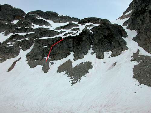
Mount Arriva / Silent Lakes route
Route - The West Ridge
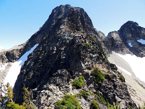
Fisher Peak's west ridge, just as it stops being a hike and becomes a climb
At the top of the “Silent Wall” turn east and start up the obvious ridge. At first it is easy hiking on wide open terrain, as the ridge ascends and dips a couple of times. Suddenly, at a dip, it turns into a climb. Careful examination of each obstacle usually reveals which way to go, the sharpness of the ridgecrest makes it easy to stay on route. Sometimes you stay right on the crest, in a few other spots bypassing small gendarmes is easiest, usually on the right, just look for the boot track to spot the bypasses.
Then at the aforementioned vertical step,
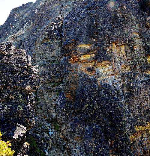
The fracture on the left side is the key to getting up through this vertical section.
there is a crack on the left side. It is actually fairly easy, but on the return trip down-climbing it with that 1000+ feet of exposure off the north side certainly holds your attention. I would suggest a short rope be available just in case caution feels correct.
The summit ridge is a very enjoyable reward, couple hundred feet of easy knife edge scrambling to the highest point.
The final summit ridge of Fisher, looking back west. A climber topping the west ridge arrives at the far end of this and traverses to the summit where the photo was taken. The more detail oriented viewer will note that the two images didn't stitch together very well, but you'll still get the idea!
As an odd note, when I was there August 2013 the PVC plastic-pipe type summit register was stuck shut, as though glued. If you want to sign in, take a wrench or a new tube and a hacksaw… or maybe just have stronger grip than me.