
|
|
Mountain/Rock |
|---|---|
|
|
40.76542°N / 110.6337°W |
|
|
Duchesne, Summit |
|
|
Hiking |
|
|
Summer, Fall |
|
|
12248 ft / 3733 m |
|
|
Overview
"Red Knob Pass Peak" (12248') is an interesting looking minor peak in the Uinta Mountains of Utah. It has less than 300' of prominence, 228' to be exact, so it wouldn't make some people's list, but it is a beautiful peak surrounded by beautiful scenery. On Scott's list of Utah Peaks over 12000' with over 200' of prominence, it comes in at #85.It is a short side trip along the way to bigger pursuits as it is an easy .6 miles southwest from the saddle between Wasatch Benchmark (13156') and Mount Lovenia (13219').
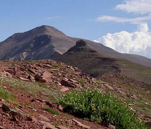
"Red Knob Pass Peak" sitting in front of Wasatch Benchmark.
"Red Knob Pass Peak" from the Wasatch/Lovenia saddle
It is located .22 miles to the north northeast of Red Knob Pass from which it gets its unofficial name. It looks knobby in all directions and is even knobbier than the officially named Red Knob which is located 1/2 mile to the northwest.

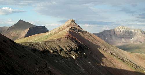
Red Knob Pass and "Red Knob Pass Peak"
"Red Knob Pass Peak" and Red Knob
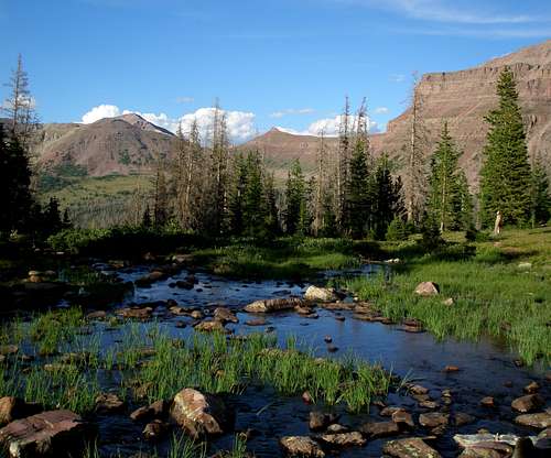
The summit looks over Lake Fork Basin to the south and the West Fork Blacks Fork to the west.
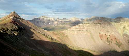
Lake Fork Basin from the summit

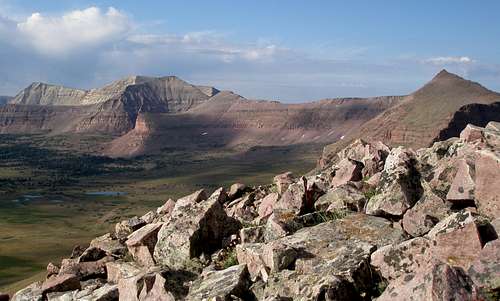
Looking over the West Fork Blacks Fork and S and N Allsop Peaks
This is a very distinctive looking peak and although it is one bump of many on a ridge, it's sillouette is easily recognizable from all directions.
From the outlet of Dead Horse Lake
Getting There (East Fork Blacks Fork)
If not coming from Salt Lake, find your way to Mountain View Wyoming and follow the directions from there.If coming from Salt Lake, head east on I80 to Wyoming. Once in Wyoming, take exit 34 towards Fort Bridger. Go through Fort Bridger about 5.1 miles to a 4 way intersection with a blinking red light. Turn right onto Wyoming State Route 414. Go through the town of Mountain View where there is a 24 hour Maverick gas station and convenience store, a small ShopKo, a Pizza Hut, and a Subway. At the south end of Mountain View, 3 miles from the blinking light, turn right onto Wyoming state route 410. After 13 miles you will see a sign that says the pavement ends in 750 feet. Shortly you will see another sign for "Blacks Fork River Access Area" and then another one that says "Wasatch Nat'l Forest/Meeks Cabin 13". If you miss all the signs, don't worry, the three sets of rumble strips should wake you up. Do as the signs say and turn left. The road you turn onto starts out paved but soon changes to dirt. Follow the main road 23.6 miles to the signboard (just past a gate) for the East Fork Blacks Fork Trail. The trail start is just before the signboard. There is no parking right at the trail start. Instead, continue on the road for just a few feet and turn right and then left into the parking lot.
In the summer of 2013, the dirt road was in excellent shape to Meeks Cabin Reservoir. Past the reservoir it was still good, but less so. Past the Utah/Wyoming state line, it degraded a little more but was still fine. Past the turn for the Mirror Lake Highway with about 5.5 miles to go to the trailhead, it got annoyingly bad with many rocks, both loose and embedded with most of the dirt washed away. I had no problem with a Subaru Legacy (not Outback), but had to drive pretty slow.
Routes

"Red Knob Pass Peak" viewed from the south southwest

The south side of "Red Knob Pass Peak"
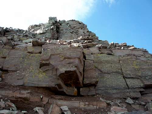
North side cliffs of "Red Knob Pass Peak"
There are several ways to approach "Red Knob Pass Peak". One is to follow the Highline Trail either east from the Mirror Lake Highway or west from the Leidy Peak area. To approach from the south, use the Lake Fork River Trail from Moon Lake. From the north, you can either use the West Fork of the Blacks Fork Trail or the East Fork of the Blacks Fork Trail (route page coming soon).
The straight line distance in miles from the trailheads to the peak is shown below.
West Fork Blacks Fork: 8.4
East Fork Blacks Fork: 9.7
Highline Trail/Mirror Lake Highway: 12.4
Lake Fork Trail/Moon Lake: 15.5
Highline Trail/Leidy Peak: 42.9
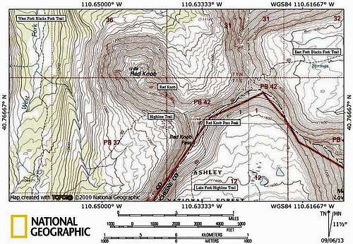
Topo map for Red Knob area
The Highline Trail traverses the west side of the peak less than .15 miles from the summit. The East Fork Blacks Fork Trail/#102 traverses its south side, .07 miles from the summit. However, the very top of the peak is ringed with cliffs so it might not be so easy to get to the top in a direct manner. The cliffs on the north and west sides did not look like anything the casual hiker would want to attempt. We came from the east side along the East Fork Blacks Fork Trail and found it very easy to scramble to the top from that direction.

Heading to "Red Knob Pass Peak" from the east

Heading to the top from the east.
Red Tape
Normal wilderness area restrictions apply. Check the signboard at the trailhead for the most up-to-date information. Do not camp within 200' of the trail or a water source.When to Climb
The summer hiking season typically runs from the beginning of July to mid September. However, some of the stream crossings would be quite difficult at the beginning of July, but should be easier in August.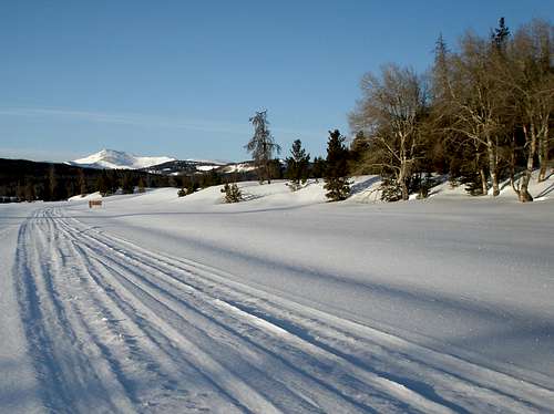
The unplowed access road south of Meeks Cabin Reservoir in late April
Winter ascents would be tough due to the access roads being unplowed. For the East Fork Blacks Fork Trailhead, plowing stops at the north end of the Meeks Cabin Reservoir, over 11 miles away, where there is a parking lot but no restroom. The road is then well snowmobiled and groomed to the turnoff for the Mirror Lake Highway. From this point, in February 2013, we saw just a few snowmobile tracks heading in the direction of the trailhead, so I think it possible, but not 100% certain that you would find a track all of the way to the trailhead.
If you wanted to approach via the Mirror Lake Highway, the highway is not plowed between mile marker 15.6 (Soapstone Basin turnoff) and mile marker 48 (North Slope Road #058). Both end points have parking and restrooms.
Camping
There is a campground just past the parking lot with about 10 sites. It is free, but there is no water. It is extremely unlikely that you would find it full as I've never seen more than a couple of sites occupied and several times it's been completely empty.There are numerous places to camp near the trail but remember that you need to be 200' away from the trail and any water source. Be warned that you might encounter sheep in the grassy meadows so it is best to camp above them.