
|
|
Mountain/Rock |
|---|---|
|
|
42.70970°N / 109.157°W |
|
|
Sublette |
|
|
Hiking, Mountaineering, Trad Climbing, Big Wall, Scrambling, Skiing |
|
|
Summer, Fall |
|
|
12620 ft / 3847 m |
|
|
Overview
East Temple Peak is a beautiful and spectacular mountain in the Wind River Range of Wyoming. Its classic and spectacular shape when viewed from the north belies the fact that the southwest ridge hides one of most accessible routes up a major peak in the Wind River Mountains.
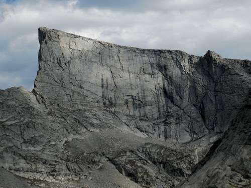
East Temple Peak is certainly a mountain of contrast. While the southwest ridge is a class 2-3 scramble, some of the most difficult rock climbs that have been done in the range have been done on the walls of this mountain. The routes up the vertical walls of East Temple Peak still haven’t been freeclimbed yet, but this will likely change with the next generation of climbers. Because of their difficulty, the technical routes on East Temple Peak are often viewed, but rarely climbed.
The summit viewpoint is a real classic and contains a spectacular perch looking over the edge of a diving board of stone. Just to the north of the summit of East Temple Peak stands a detached pinnacle, the Lost Temple Spire, though the spire is almost invisible when viewing East Temple Peak from the north since it blends in with the wall so well.
The area around Deep Lake and East Temple Peak doesn't see near the amount of traffic as does Cirque of the Towers to the north, but by Wind Rivers standards, this is a popular basin. The vast majority of the technical climbers visiting the basin focus on Haystack Mountain, located just north to East Temple Peak. Most hikers just visit the lakes in the basin, so the scramble up East Temple Peak usually provides a break for those seeking solitude.
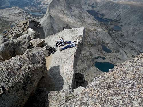 Looking 2300 feet down (700 meters) from the summit of East Temple Peak.
 Getting There
Big Sandy Trailhead
There are several ways to reach this trailhead. All driving routes include much travel on gravel roads, but the gravel roads are generally in good condition and are passable by all cars in the summer season.
From the South
Option A
This may be the easiest route to follow, but I don’t know the exact mileage of the turnoff off highway 28. From Farson (~40 miles north of Rock Springs), leave US 191 and turn east on WY State 28.
Drive to just after South Pass and turn north on a road clearly marked for “Big Sandy Entrance”. If you reach the rest area along the highway, you have gone 0.6 miles too far.
Follow this good mag and gravel road north for 19.8 miles and turn right at the junction. Drive 5.5 miles along the signed road to a junction signed for the Big Sandy Campground.
*All options for the Big Sandy Trailhead share the route from here on. The road is also rougher from here on. Drive along this dirt and gravel road which becomes FS 850. Drive the main road 11 miles to the trailhead, ignoring the side roads to the summer homes and lodge.
Option B
This route is a bit harder to follow (take a good map), but is shorter and slightly rougher. From Farson, leave US 191 and turn east on WY State 28. After 4.6 miles turn left on a good road and keep straight for the first two junctions. After about 20 miles, there is a junction with a sign saying you can turn right to reach Big Sandy Entrance. Despite the sign, it is actually better to stay straight and at mile 33 from Highway 28, and turn right and drive another 7.1 miles to the junction signed for Big Sandy Entrance. Refer the paragraph with the asterisk for the rest of the route.
As mentioned, make sure to have a good map for this driving route.
From the East
This route shares the same access road as Option A above. From Lander, drive about 46 miles on Wyoming State 28 to a junction. This is 0.6 miles past the rest area and just before South Pass. From here, turn north on a road clearly marked for “Big Sandy Entrance”. The rest of the route is the same as the one described above for Option A.
From the North
From the north, drive about 12 miles south of Pinedale on US 191 and then turn east on Wyoming SH 353. Follow this highway for 18 miles to where the pavement ends and continue another 0.7 miles to a junction. Turn left then and stay right at the junction at 2.8 miles. Continue for 4.7 miles to another junction and turn left for another 7.1 miles to another junction. Refer the paragraph with the asterisk for the rest of the route.
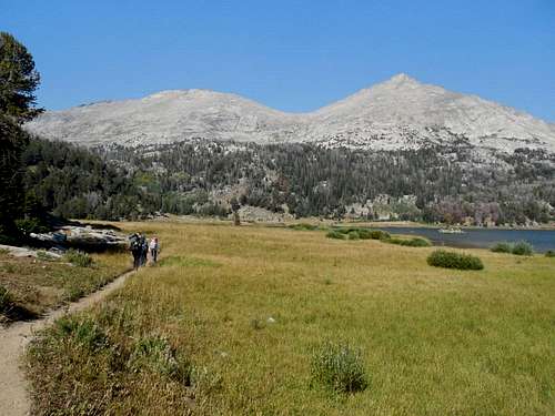 This is the trail near Big Sandy Lake.
Little Sandy (Sweetwater) Trailhead
I haven't been to this trailhead, so can't comment on the condition of the road. It is said to be rough, but passable high clearance 2WDs and AWDs, though 4WD is preferable.
The route shares the same approaches ad the Big Sandy Trailhead, but is farther south. The route from the south will be the easiest to follow.
Use the same directions as "Option A" in "From the South" or the directions for "From the East". With a good map you should be able to make your way to the trailhead.
Bill Reed also has some directions on Summitpost on the page below:
Sweetwater Trailhead
Approach Routes
There are several approaches that can be used to access the area around East Temple Peak.
Via Big Sandy Entrance
From Big Sandy Entrance, the trail is followed to Big Sandy Lake (5.2 miles).
Option A
From Big Sandy Lake, the main trail goes 3.4 to Clear Lake, Deep Lake, and then follows an unmaintained trail to the pass above Temple Lake.
From the area of Deep or Temple Lakes, you can access the technical routes from Deep Lake, the Northwest Rib or Northwest Face from Deep Lake, or the Southwest Ridge from Temple Pass (Temple Pass is 10.5 miles from the trailhead).
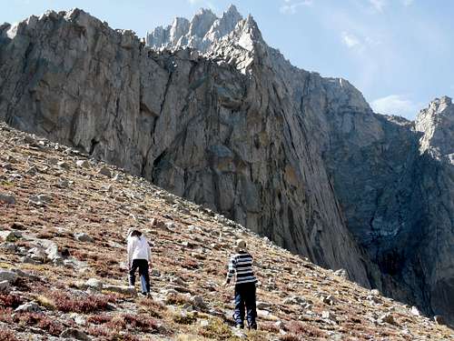 Approach to Temple Pass from Temple Lake.
Option B
This route follows an abandoned trail and is harder than the trail above, but offers solitude. From Big Sandy Lake, follow the abandoned trail along Rapid Creek to Temple Lake (see above).
Via Little Sandy/Sweetwater Trailhead
This trail is no longer maintained, but it should offer solitude. From the trailhead, a good trailhead is followed to Little Sandy Lake and then follows Little Sandy Creek up to Temple Pass.
This trail is only half a mile longer to Temple Pass than the one from Big Sandy, but is slower since it isn't maintained.
Climbing Routes
Non Technical or Easy Technical
Southwest Ridge via Temple Pass (Class 2-3)
This is the easiest route on the mountain. The route is either class 2 or class 3 depending on the route variation you take, but with careful route-finding you can definitely keep the route under class 3.
Temple Pass can be reached from the Big Sandy or Little Sandy Trailheads. The pass is 10.5 to 11 miles from either trailhead. From the pass, the route simply follows the ridge to the summit. There are few real obstacles and the views from the summit are fantastic.
See the Route Page for details.
 Climbing the Southwest Ridge of East Temple Peak.
Northwest Rib/Northwest Ridge via Deep Lake (Class 4)
From the minor saddle between Deep and Temple Lakes, the Northwest Rib of East Temple Peak can be climbed. It is a Class 4 scramble until it reaches the Southwest Ridge.
See the Route Page for details.
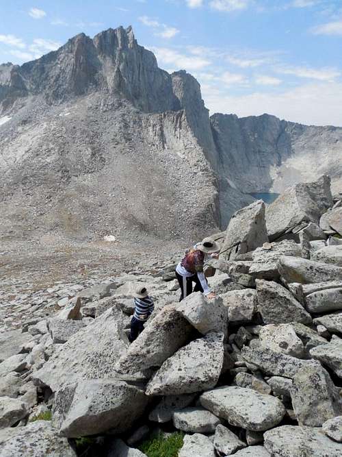
 The Class 4 Northwest Rib route on Temple Peak is to the right foreground.
Northwest Face, Right Side (Class 4)
To the right of the huge and sheer Northwest Face of East Temple Peak, a couloir is aligned diagonal to the right before ledges slant left. This is a Class 4 route that joins the Southwest Ridge.
Technical
To date, no free routes exist on the towering faces of the mountain. It is likely that this will change in the next few years.
Below is a brief description (see Kelsey's Climbing and Hiking the Wind River Mountains book) of each route.
Northeast Face (VI 5.9 A3)
A route on the wall above the basin holding Black Joe Lake. Some rotten rock.
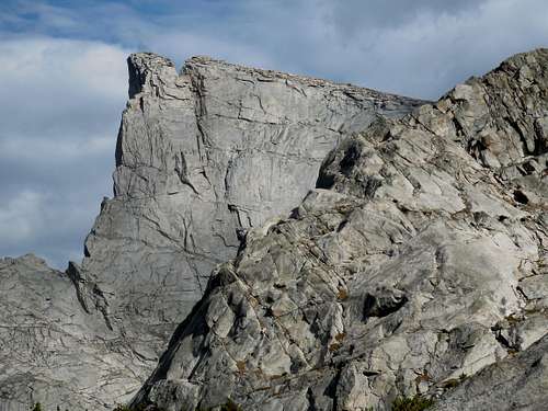
Northwest Face (V 5.8 A4)
Climbs the steep wall's overhanging dihedrals, one above the other. The first ascent in 1961 over to days was one of the earliest Yosemite technique climbs in the range.
 The big northwest wall of East Temple Peak. Thus far, there are no free routes on the wall.
Red Tape
East Temple Peak and its approaches are located within the Bridge Wilderness.
Here are the rules and regulations directly from the Forest Service:
Wilderness Regulations
The purpose of these regulations is to assure protection and quality of the wilderness resources as well as the safety of the wilderness visitor. Violation of regulations is punishable by fine and/or imprisonment. The following acts ate PROHIBITED within the Bridger Wilderness:
Possessing or using a motor vehicle or motorized equipment such as a chainsaw.
Possessing or using a hang-glider or bicycle.
Use of aircraft without written permission.
Camping within 200 feet of a trail or lakeshore.
Open campfires within the seven special management areas.
Horse grazing within 200 feet of lakes.
Placing or maintaining a cache in the wilderness.
Cutting or otherwise damaging any live tree or other vegetation without a permit.
Staying in one campsite for more than 16 days. Visitors who vacate a campsite after 16 days may not return to the same site for at least 5 days.
Pack and saddle stock will be tied so as not to cause injury or damage to any tree, vegetation or soil.
Party size is restricted to 15 people and 25 pack and saddle stock.
Non-burnable garbage will be packed out, not buried.
Bulk hay or straw is not permitted.
Camp structures such as hitch racks, tent frames, pegs and fire rings will be dismantled after use.
 Make sure to follow all Wilderness Regulations.
When to Climb
August and early September is the most popular time to climb here. July is fine too, but this area gets heavy snowfall, so winter snows tend to stay late and through most of July. Stream crossings can be very problematic in June and July.
Mosquitoes are at their worst in July (this area has some of the thickest mosquito populations I've seen in the world) and slowly taper off as the summer progresses. By September there are none, or at least close to none.
Still, July can be beautiful. The extra snow around makes the area more aesthetic and the lakes can be frozen well into the month.
Big snowfalls can come in September. Though summer weather is usually really nice, be prepared for sudden snowstorms at any time of year.
Winter ascents of East Temple Peak are certainly possible, though it’s a long trek in when the road is closed. Because of heavy snowfall, trail breaking will not be easy and be aware of avalanche danger. For the well prepared climber, a winter ascent would prove a worthy challenge.
For skiing, late Spring still has plentiful snow, but access is much easier than it is in winter and early spring.
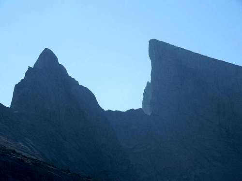 Steeple Peak (left) and East Temple Peak (right) as seen in early morning light in September.
Camping
Vehicle Access Campsites
There is a nice campground near the trailhead that usually has space on most summer weekends. The fees as of 2013 are $7 per night.
There are also many informal campgrounds within the national forest lands en-route to the trailhead.
Backcountry Campsites
There are many campsites between Big Sandy Entrance and Big Sandy Lake.
The most popular campsites along the approach are Big Sandy Lake, Clear Lake, and Deep Lake. Because you must camp 200 feet from the lakes and 200 feet from the trails, campsites can be at a premium during holiday weekends.
One of the best options are the slabs and benches between Clear Lake and Deep Lake. There is usually plenty of places to find a nice and scenic campsite there, especially on the benches below Deep Lake.
Temple Lake has some good campsites and is much quieter than the other lakes mentioned.
Make sure to use low impact techniques, especially near or above timberline as the alpine areas are fragile.
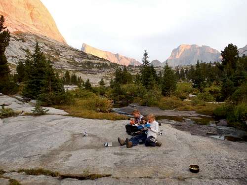 Dinner time near camp and just below Deep Lake. Haystack Mountain is far left. East Temple Peak is the pointy peak center left. Temple Peak is to the right.
The approach from Little Sandy is said to have many fine campsites and is very little used so it shouldn't be a problem finding a nice and quiet place to camp.
Mountain Conditions
Click Here For Area Weather Forecast
Below is the National Weather Service Climate Summary of South Pass City. The data is from 1915-2012. This is the closest long term weather station, but be aware that higher elevations will be much wetter and colder. South Pass City is at 7850 feet elevation, so expect the temperatures on the higher elevations of East Temple Peak to be 15-20 degrees colder than in South Pass City (except for cold winter nights).
| MONTH | AVE HIGH | AVE LOW | REC HIGH | REC LOW | PRECIP |
| JAN | 26 | 1 | 55 | -45 | 1.24 |
| FEB | 28 | 3 | 53 | -40 | 1.00 |
| MAR | 34 | 9 | 65 | -33 | 1.16 |
| APR | 45 | 20 | 75 | -22 | 1.40 |
| MAY | 57 | 28 | 83 | 0 | 1.54 |
| JUN | 68 | 34 | 89 | 6 | 1.28 |
| JUL | 76 | 40 | 91 | 18 | 0.86 |
| AUG | 75 | 38 | 90 | 15 | 0.88 |
| SEP | 65 | 30 | 84 | -5 | 0.99 |
| OCT | 53 | 22 | 80 | -26 | 1.03 |
| NOV | 37 | 11 | 62 | -30 | 0.91 |
| DEC | 28 | 3 | 55 | -46 | 1.06 |