
|
|
Mountain/Rock |
|---|---|
|
|
35.43038°N / 83.20153°W |
|
|
Jackson |
|
|
Hiking |
|
|
Spring, Summer, Fall, Winter |
|
|
5008 ft / 1526 m |
|
|
Overview
I have chosen to list this peak as "Sylva Pinnacle" to differentiate it from the literally scores of other summits called "The Pinnacle" here in the east. There are many such peaks, so I feel obligated to list this one in such a way as to let the reader know which one I'm writing about.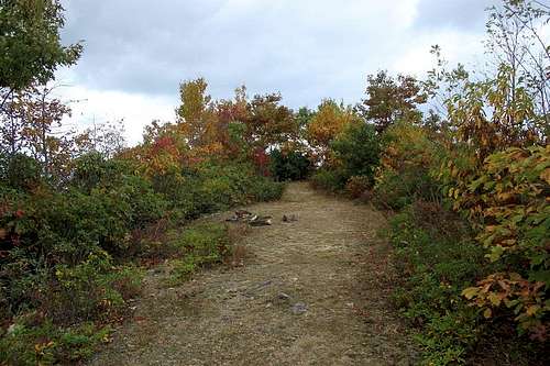
This is NOT the end of the trail, and this is NOT the Pinnacle! Some people turn around here, thinking the two campsites here are the Pinnacle. In fact, the trail continues just beyond the second campsite, descending into the forest on the left of the last campsite. Follow that onto the treeless summit.
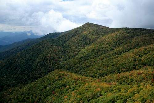
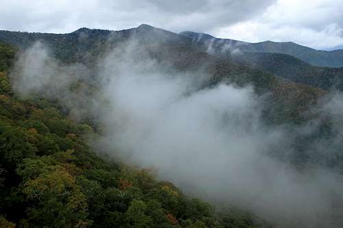
The Sylva Pinnacle stands high above the town of Sylva, but is not so easy to pick out from the vast wall of very high peaks that loom behind it. This rocky summit is, in fact, probably a sub-peak of Pinnacle Bald, which itself is part of Blackrock Mountain, one of the higher members of the Plott Balsams. Within sight of Sylva Pinnacle are a number of major peaks in this part of the southern Appalachians that lie close to the Great Smoky Mountains.
Perry Top, another higher summit that looms nearby.
This peak had been on my bag list for a very long time. Almost fifteen years, in fact. But something always kept me from getting to this corner of North Carolina to hike to the summit and strike it off my list. In a lot of the propaganda I'd read about the summit, it had been listed as a scramble. There are not a lot of peaks here in the south that meet that definition, so I was very much looking forward to gaining the top just to say that I'd bagged a peak that was not a walk-up. However, by the time I'd climbed to the top, I discovered that the tales were just that--so much hot air. You do have to walk up the rocks, but it's not by any stretch a scramble. The other three sides of the peak would involve scrambling or even technical climbing, but the main route is merely a rocky trail.
Looking north, I could see Blackrock Mountain and Waterrock Knob, two of the higher members of the Plott Balsams.
The peak is protected within the aptly named Pinnacle Park. The acreage that protects the peak and ridges around it was once the watershed for the town of Sylva. Many towns have decided that there's no need for an official watershed these days, and so the vast lands that protected their access to clean water was left in limbo. In the case of Sylva, the town made the decision to keep those lands under protection by transforming the watershed into a public park where hiking and camping is allowed. I sincerely hope that many other towns and cities here in the southern Appalachians make similar decisions regarding their old watersheds.
Because the land was jealously guarded for so many decades, the slopes are home to a wonderful mature hardwood forest. I suspect that there may at least be patches of old growth forests in the park, but I'm not sure.
The Sylva Pinnacle itself is an exposed and rocky summit affording 360-degree views of the surrounding mountains and valleys. Sylva is obvious to the south with many other major summits rising all around. Some of the more notable peaks nearby are Perry Top, Blackrock Mountain, Pinnacle Bald, and Waterrock Knob. The hike is pretty easy and straighforward and lacking views until just before you reach the Pinnacle itself. But even the hike through the forest is a worthy one, passing as it does through unbroken, mature, cove hardwood forests.
Getting There
From downtown Sylva, take Skyland Drive east (SR 1432) and turn leftonto Fisher Creek Road (SR 1446). The parking area is at the end of
Fisher Creek Road.
Route
I took the Pinnacle Trail which is 3.5 miles in length and follows an old access road that was once used by the town of Sylva to regulate the watershed. For most of the route, the trail resembles a roadbed instead of a footpath. It is a relentlessly steep trail until you gain the ridge and hang a sharp left toward the peak. At that time the route is an easy series of mild ups and downs until just before the summit. Toward the end, it appears as though the trail ends at a couple of campsites on a ridge top with some old rock fire rings. Look closely, though, for a path leading into the forest just beyond the last of the two campsites. This leads downslope a bit and onto the exposed rocky top that becomes The Pinnacle. Total elevation gain from the parking lot to the summit is roughly 2200 feet. The trail is well maintained and well signed all along the way. There is pretty much no way to get lost or misdirected. There are few faint manways leading into the forest, but just avoid these and pay attention to the signs.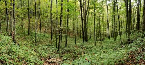
The forests of Pinnacle Park are worth seeing, even if you don't make it all the way to the summit.