
-
 5236 Hits
-
 81.01% Score
-
 13 Votes
|
|
Mountain/Rock |
|---|---|
|
|
43.19125°N / 4.73341°W |
|
|
Hiking, Mountaineering, Scrambling, Skiing |
|
|
Spring, Summer, Fall, Winter |
|
|
8009 ft / 2441 m |
|
|
Overview
 Morra de Lechugales summit block
Morra de Lechugales is the highest peak of the Macizo de Andara, part of the Picos de Europa, culminating at 2441 m (after the Adrados map) or 2444 m (after the Editorial Alpina map). It so marks the “lowest” part of the three massifs of Picos de Europa.
In addition Morra de Lechugales is far from being a prominent and eye-catching mountain, as Pena Santa de Castilla or the mighty Torre Cerredo. Our top-of-the-Macizo mountain is a huge oblique limestone block on the ridge from Picos and Pica del Jierro to the north to Cortes and Cumbres Avena to the south. It just happes that the uppermost stone of this limestone block is some meters higher than the broad and dominating Silla del Caballo Cimero, east of Morra di Lechugales or about 21 m higher than Pica del Jierro, another huge and dominating mountain within the Macizo de Andara.
Nevertheless climbing Morra di Lechugales is fun. Don´t miss that when you are roaming through the Andara mountains. The 360 degree views are just a blast. You look down about 2000 meters to Liebana region and Potes, about 1000 m down to Duje valley and Puertos de Aliva. The whole Macizo Los Urielles stands out to the west. To the north and east are the mountains of Andara and the Cantabrian peaks. To the south the Pena Prieta region stands in front of the huge plains of Castilla and Leon. BOAAHHHH……………
Most of the routes to the Morra pass near several other interesting peaks and summits which can easily be “bagged” as an encore. You may climb through a days hike: La Rasa de la Inagotable, Pico del Grajal de Abajo, Pico del Grajal de Arriba, Pica del Jierro, Picos del Jierro, Silla del Caballo Cimero and the Morra.
And then the crux of the Morra, which is largely discussed on Spanish mountaineering internet sites: to climb the summit block you have to overcome a 10 meter high rock which requires UIAA grade II+ to III- moves, nowadays with the help of a fixed rope (2013) which is not bad for the descent.
Getting There
 Morra de Lechugales as seen from Torre Blanca; Picos de Santa Ana in front
Main trailheads are
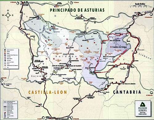
You reach Sotres or Jito Escarandi on road number AS-264 from Arenas de Cabrales (look up the Macizo de Andara SP page how to get to Arenas de Cabrales) to Poncebos. Turn there on road number CA-1.
Follow CA-1 until you reach Sotres, leave the village on that road to the east and park your car at or near the first switchback after the village limits.
For Jito Escarandi follow CA-1 until you reach this col between Sotres and Tresviso; there is a hiker parking area on the right side of the road.
For Caseton de Andara leave your car at Jito Escarandi and follow the old mine road in southern direction until you reach the Caseton (about 1 hour to walk).
For Tanarrio, Lon or Brez follow road number CA-185 from Potes in the direction of Espinama / Fuente De.
Main Routes Overview
 Morra de Lechugales as seen from Picos de Jierro
Northern Route
Route via Collado del Mojon and Pico del Grajal de Arriba
Trailhead: Jito Escarandi or Caseton de Andara
From Jito Escarandi take the old mine road in the direction of Caseton de Andara.
Pass by the Caseton at a broad road switchback on a trail west of the hut and regain the mine road above or go to the hut and follow the mine road. Above the route junction stay left and follow the steep road up to the Minas de la Providencia. Instead of entering the huge Vega del Hoyo Oscuro stay right and ascend to Castillo de Grajal on a mine road. Follow that road up to Collado del Mojon and descend on that road into the upper parts of Canal de las Arredondas south of the Collado. A swithback brings you in western direction – pass the south slopes of Pico del Grajal de Abajo and regain the ridge at the col west of the Abajo peak.
Follow this road/trail in western direction. First the ridge is steep, narrow and rocky. After a while you enter a gentle meadow slope. Follow the mine road until its enters the Hoyo del Evangelista. Leave the road there and ascend the meadow slope on a narrow and marked trail to the summit of Pico del Grajal de Arriba. From there follow the cairns on the ridge crest or a bit south of it until the trail starts to ascend the east ridge of Pica del Jierro.
 Approaching Morra de Lechugales; traverse below Picos del Jierro
Follow a cairned narrow trail which branches off to the left and traverses the southeast slope of Pica del Jierro above Hoyo Evangelista. The trail climbs up steeply to a scree field below the Picos del Jierro ridge. At a second trail junction turn left and follow the cairned route around some rocks into the notch between Morra di Lechugales and Picos del Jierro.
Go on in southern direction and climb some easy rocks south of the notch. Descend shortly then to the lower end of the oblique summit block of the Morra. Climb the short crux (UIAA grade II+ / III-; fixed rope in 2013) and scramble up to the summit buzon.
South routes
Canal de las Arredondas route
Trailheads: villages of Lon or Brez
Follow the roads from both villages in northern direction to Prao La Mayor, where these roads meet. Ascend now the long Canal de las Arredondas to the mine road below Collado del Mojon (long ascent!)
 Summit view to Macizo Los Urielles Summit view to Macizo Los Urielles |  Summit view to the southern Cantabrian mountains Summit view to the southern Cantabrian mountains |
At the mine road turn left and follow the above described northern route via Pico del Grajal de Arriba and the Pica and Picos de Jierro traverses to Morra de Lechugales.
Canal de Lechugales route
Trailhead: Tanarrio
Take the road north of Tanarrio, branching off to the left from the road to Brez. Take the left hand road at a road junction about 1,3 km later. This road ends at the end of the long Canal de Lechugales. Ascend the Canal until you reach the col between Picos del Jierro and Silla del Caballo Cimero. Turn left and scramble in western direction until you reach the trail coming from Pico del Grajal de Arriba to Morra de Lechugales. Turn left an that trail and follow it up to the summit.
The route is steep, long and at least partly off-trail.
 Asturian mountaineers lining up at the crux and summit block
Ski routes
Morra del Lechugales / Picos and Pica del Jierro can be summited with skies, too. For the last rock parts you may need crampons and an ice axe.
From Jito Escarandi or Caseton de Andara go to Collado del Mojon and follow the west ridge to Pico del Grajal de Arriba. Traverse the Pica and the Picos de Jierro on their south and east side slopes (depending on the conditions you may have to carry your skies) and summit Morra de Lechugales following the summer routes.
The Canales de las Arredondas and de Lechugales are ski routes, too. As the Canal de Lechugales is very steep it seems to be a preferred downhill area.
If you plan a ski round trip from Lon or Brez, ascend the Canal de las Arredondas, traverse to Pico del Grajal de Arriba, Pica and Picos del Jierro and Morra de Lechugales.
Ski down Canal de Lechugales until the broad chute from Collado Untuje de Tanarrio comes down to your left.
Ascend to the Collado (about 300 m) and ski down the Canal de Untuje tp the lower end of Canal de las Arredondas.
A very, very long and strong day or a two days undertaking with a night at Caseton de Andara.
Red Tape & Accommodation
National Park boundaries
Red Tape
Morra de Lechugales is part of the Parque National de los Picos de Europa.
The entrance to the national park is free, you need no permits.
The regulations for the park can be seen here.
 A colourful guest at the summit
Accommodation
Mountain hut
Caseton de Andara with 20 places, food and drinks; guarded throughout summer
Gear & Mountain Condition
 Climbing the Morra crux
Morra di Lechugales is mainly a spring, summer and autumn outing. All the routes are hiking routes, sometimes off-trail (Canal de Lechugales), but all marked at least with cairns.
The summit block, however, requires a short climb with UIAA grade II (some say III-, I won´t say that), actually (2013) with the help of a fixed rope, dangling down half the height of that nice rock wall.
Morra de Lechugales or at least the secondary summit north of the Morra (point 2432 m on the Adrados map) can be summited with skies, too.
You need normal hiking gear for a summer and autumn tour on Morra di Lechugales. Gaiters and hiking poles may be useful in springtime.
For winter / spring time ski touring you need full ski tour gear and avalanche protection. Depending on the snow conditions an ice axe and crampons for traverses by foot are recommended.
A Spanish avalanche bulletin for the Picos de Europa (Boletin de Peligro de Aludes) can be seen here.
Current Weather for Sotres:
Current weather for Potes
Maps & Guide Books
 Morra de Lechugales and the highest Andara peaks as seen from Pena Vieja
Maps
Picos de Europa; Central and Eastern Massifs (Los Urielles Y Andara); Topographic Map, scale 1 : 25.000 with Hiking Trails; Adrados Ediciones –
the best and most detailed map as far as I know
For more information see the Adrados website (only in Spanish).
A good hiking map, not too detailed but sufficient for simple hikes:
Parque Nacional de Picos de Europa; 2 Mapas Excursionistas, Escala 1 : 40.000, Macizo Central y Oriental; Macizo Occidental; Editorial Alpina
Guide Books
Standard guide book in English:
Robin Walker: Picos de Europa, Walks and Climbs, Cicerone guide
Spanish publications and more maps can be purchased in the towns and villages round the Picos.