
|
|
Mountain/Rock |
|---|---|
|
|
39.44980°N / 115.9992°W |
|
|
Eureka |
|
|
Hiking |
|
|
Spring, Summer, Fall, Winter |
|
|
9573 ft / 2918 m |
|
|
Overview
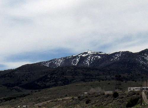
Prospect Peak from US 50
This is the perfect peak to grab if you are in a hurry to get from nowhere to nowhere in the middle of Nevada as you travel the "loneliest highway" in the USA, US 50. Ever since they named it the "loneliest highway" in the US, it isn't so lonely as more and more people travel it just to get a feel for it.
Just outside of Eureka, is Prospect Peak, one of those unfortunate mountains that has been scarred and marred by the placement of communication structures that has resulted in the top of the mountain being bulldozed and forever changed. A road leads right up to the very top and there is no gate to stop you from heading up to the summit but it is a good idea to park at the bottom and walk up or go cross country to make it a bit more sporting. But, if you are in a hurry and you have a vehicle with high clearance and don't mind a road with a drop off or two, then you can white knuckle it to the top. Actually it isn't that bad a road but it isn't made for passenger vehicles so it'd be smartest to park and walk it. When Ken Jones and I visited, snow blocked us in the lower reaches of the road so we walked up to the summit, not bad since it was our second summit of the day.
At 9573' feet high, the main attraction however is the fact that this mountain has close to 2300' of prominence and is the main reason why Ken Jones and I made the effort to hike up this thing to get the summit. Coming in at #126 on the Nevada prominence list, it is worth the effort whether you hike it or can drive it.
The town of Eureka is not very far away and has places to eat and places to sleep. Eureka used to have a Best Western but it is now called the Eureka Gold Country Inn and is still getting nice reviews on Trip Advisor. A nice place for Breakfast and lunch is the Pony Express Deli located on the southern end of town. I haven't had dinner in Eureka so I can't make any recommendations but we did find the Pony Express Deli by asking at the Chevron station in the middle of town. There is a good grocery store not far from the gas station so the basics are there. Mining is a big deal in this area and there is a reason the town is named "Eureka" but you probably already figured that out.
Getting There
Find your way to the small historic mining town of Eureka on US 50 and take a moment to gas up, grab a bite or just relax for a moment or two. To get toProspect Peak from the center of Eureka, I offer these suggestions:
From Eureka, head south a couple of miles or two to the Windfall Canyon road (lat/long 39.4859,-115.9478). Turn right (west) and follow this road as it winds its way toward a huge mine operation at the end of the road. The road is broad for the most part and heavily traveled by trucks during the week so a weekend might be the best time to visit. Continue on the Windfall Canyon road for about 7 miles (from US 50) to a right hand turnoff to the Rocky Canyon Road at 7800ft (lat/long 39.4168,-115.9980). This high clearance rough road then switchbacks north a few times for about 2.6 miles to the communications covered summit .
Dennis Poulin did this mountain in 2013 so I will also add his remarks about his visit to the summit:
"This is an easy one to tag from the town of Eureka on Hwy 50. I headed east on Hwy 50 from Eureka a couple miles to the signed road on the right for Windfall Canyon. I turned right and zeroed my odometer. This is a nice wide gravel road. At 1.6 miles I stayed straight and at 2.7 miles I continued through and inactive mined area. At 4.1 miles I reached a saddle and kept right, descending into the next drainage. The road loses about 400 ft of elevation in the next 2.7 miles before reaching a fork with the left one going to another mine area and the right fork enters Rocky Canyon. This road isn't as well maintained and gets a little rocky and steep as it makes its way to the summit. I stayed on the main road for another 2.6 miles and arrived at the summit with several comm towers. The summit is about a 5 ft ascent in the middle of the tower complex."

The road
 The stopper The stopper |  Nearing the top Nearing the top |  Ken just about there Ken just about there |
Route
If a drive up, the route is covered nicely by Dennis Poulin's remarks shown above in the "getting there" section. If you hike it from near the bottom, allow enough time for a 5 mile round trip hike with a bit over 1000 feet of elevation gain. A witness benchmark was found on a small remnant of the top just off the side of the road as you reach the bulldozed and leveled off summit.  Atop the highest bump Atop the highest bump |  Witness Marker on the bump Witness Marker on the bump |  Ken checks out the area Ken checks out the area |

The high spot
Red Tape
None that I am aware of.  West West |  East toward Diamond Mtn East toward Diamond Mtn |  North North |

Roberts Creek range in the distance
When to Climb / Summit information
It is probable that this peak could be climbed during any month of the year. In winter, it might make a nice snowshoe effort.We did not find a register nor a central benchmark on this mountain which wasn't surprising. We did find a witness marker on what we deemed to be the highest remaining spot of what once was part of the natural summit. We looked for a central benchmark but most likely it was lost when the communications structures were placed.
Those that I know who have visited the top (thanks to peakbagger.com and lists of John) are as follows:
Al Sandorf, Andy Martin, Brian R., Brad Boester, Mark Nichols, Gordon MacLeod,
John Vitz, Donna O., Dennis Poulin, Ken Jones and myself.

Camping
The town of Eureka has several motels that you could utilize as the land near the mountain has many private property issues and would not be a good place to camp. There is a campground between Ely and Eureka.Illipah Reservoir Campground:
Illipah Reservoir is 37 miles west of Ely on Highway 50, turn at the sign for Illipah Reservoir and continue 1 mile to a road junction, turn left and continue 1.3 miles to the campground. Elevation is 6,840 feet. There is no size limit for travel trailers. Fee: none.
There are also a few campgrounds near Austin that might work out but I'd suggest you google for them if you should find interest in camping near Austin.