
|
|
Mountain/Rock |
|---|---|
|
|
40.64510°N / 118.5164°W |
|
|
Pershing |
|
|
7388 ft / 2252 m |
|
|
Overview
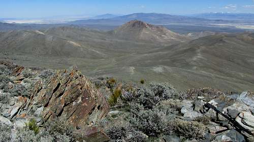
On the summit - Looking east toward Majuba Mountain
The Majumba mountain range is located not far from I-80 west of Winnemucca Nevada and east of Lovelock. The interesting name of Majumba was given its name in sympathy for the Boer victory over the British at Majuba Hill in South Africa on Feb 27th, 1881. Thus, how this strange name was decided upon had little to do with anything found in Nevada itself.
The highest spot in this small range is where the benchmark was placed and yet, the aptly named Majuba Mountain is just a bit to the northeast and is not the where you'd go to find the highest spot so one needs to be aware of this. It is also home to a mine operation. Now that one is aware that Majuba Mountain is not the highest mountain in the Majuba range, one needs to climb/hike the mountain that has the highest spot in the whole range and confirmation is assured when you find located on its top a surveyors benchmark (hence the name). With nearly 2500' of prominence, this one ranks #103 on the top Nevada prominence list so it gets a few visitors other than rock hounds and hunters visiting its slopes and summit. Cattle were grazing on its lower slopes when we were there.
We found nothing technical as this one is pretty much a walkup but the views from the summit are outstanding in all directions with some good views over toward the Black Rock Desert area.
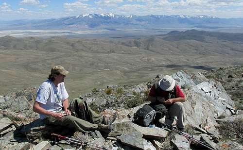
I would like to thank Brett Hathaway for his kind sharing of his pictures. I was only able to take a couple before my digital card was full and I didn't dare delete anything to make room for more. This is really an easy mountain once you resolve the roads that get you to its base. I would hope that future visitors will be kind enough to share their pictures with this page.
Getting There
On the summit - looking south
Up to this point, a 2 wheel drive passenger vehicle could probably be OK (be sure to have a good spare tire) but now you may want to have high clearance although you might be able to drive a bit further on this lesser road. Your call. It is not quite 2 miles to where a rough jeep track takes off (near a big cattle watering spot and at waypoint 40.6596 118.4970 elev 5825') and for many, this would be a good place to park and walk from. You only add a half mile to your hike if you stop here butwith high clearance and 4WD, you can continue up this jeep track to where it became the trailhead for us (waypoint 40.6557 118.5042 elev 6040') we couldn't continue up the jeep track up to the saddle was washed out and only ATV friendly. No matter, if you get to the turn off by the cattle watering area, it is still a pretty easy hike.
I need to credit Brett Hathaway with coming up with this drive in route as I had it mapped completely differently. Brett used google earth and noticed the road system that worked so well for us. Thanks Brett.
Route
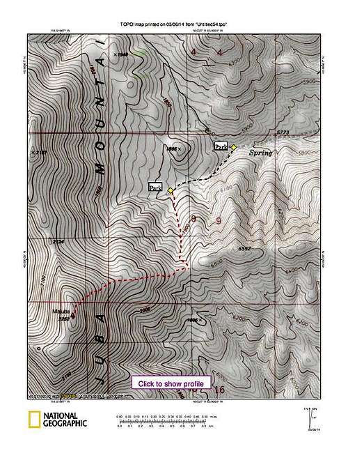
Route Map
From where we parked, we followed a jeep track (rough and washed out in spots)to the saddle and then from the saddle is was about a mile to the summit with another 900 feet of elevation gain. As is often the case, the crux of this one was the drive in.
Stats for our route: 1.3 miles each way and 1400' of elevation gain.
Other routes:
Dennis Poulin offers another route that was successful for him and you can find it HERE.
Brad Boester found his way to the summit from the southwest via Poker Pass and his information is HERE.
Red Tape
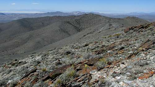
Looking northerly
None that I am aware of
When to Climb
Anytime of the year when snow isn't a factor or the roads aren't muddy.Camping
No established campgrounds in the area but car camping is permitted on BLM land. Try and find spots where others have already camped and follow the leave no trace ethics requested by the BLM and common sense.Motels are available in nearby Lovelock or Winnemucca.
Rarely visited summit

Central Benchmark
The register, found in a glass bottle near the summit was left by Gordon MacLeod and Barbara Lilley in 1995. The next peakbagger to sign:
2004 - John Vitz, Donna O.
2009 - Brad Boester
2010 - Ken Jones
2011 - Dennis Poulin
2013 - John Ide, Ron Moe
2014 - Brett, Al and myself. A month later Andy Martin and Mark Nichols
2015 - Bob Sumner
A couple of hunters had also signed in as well as a couple from Winnemucca.
That was it. Listings of those who summit can be found on peakbagger.com and Lists of John