
|
|
Mountain/Rock |
|---|---|
|
|
38.26211°N / 119.48361°W |
|
|
Mono |
|
|
Hiking |
|
|
Summer, Fall |
|
|
10727 ft / 3270 m |
|
|
Overview

View of Peak 10727 from the rocks on Mount Emma
Situated about a mile south-southwest of Mount Emma 10,525’, is the unnamed Peak 10,727. Although it has a prominence of almost 600’, this peak is often overlooked. It is located on a ridge south of the 108 highway (“Sonora Pass”) and is easily accessible.
Located not far off of US 395, which runs along the Eastern Sierra, access begins at the Obsidian Campground in northern Mono County. Reaching the summit is an easy day hike for experienced hikers in the Sierra Nevada. The peak is ideally combined with Mount Emma.
Camping is available at Obsidian Campground and sites are first come, first serve. There is access from the campground to Emma Lake and to Walker Mountain 11,563’ to the southwest.
Given it's located in the eastern extension of the Sierra Nevada range, hiking season generally begins in June and lasts through October.
Getting There
From the north: At the junction of Highway 108 and Highway 395 continue south for about three quarters of a mile and turn sharp right on forest road 066 (Little Walker Road).From the south: From Bridgeport go north on Highway 395 for about 16.5 miles and turn left onto forest road 066 (Little Walker Road).
Continue south on this dirt road, passable to all vehicles for about 3 ½ miles to Obsidian Campground at about 7,700’. You can hike from here and cut up to the road, or continue up the 4WD road about 3.3 miles to the actual trailhead at Stockade Flat 8,590’.
Route
There are a couple primary routes to the summit. Either start at Obsidian Flat and hike towards the road to Stockade Flat, or drive up to Stockade Flat. Driving up with a 4WD is probably better, because it allows for more exploration of the high country.From the trailhead at Stockade Flat, head about a mile or so to Emma Lake.
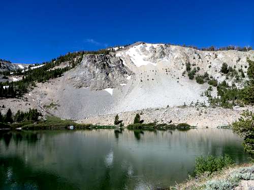
Ridge above Emma Lake
Once at Emma Lake, you can head to the back side of the lake and walk up the steep scree slopes to the saddle below Mount Emma. From there, head west opposite from Mount Emma to and up to the saddle below Peak 10,727. Once at the saddle, take a left and it is an easy 10-15 minute walk to the summit. The total distance is about 2 ½ miles from the trailhead at Stockade Flat with an elevation gain of about 2,200’.
Another option is to head to the right side of the lake and keep going to the northeast side of the ridge (see photo above). Head steeply up the forested side of the ridge and continue to the crest of the ridge. The ridge continues steeply up slope until you are above the trees. Point 10,659’ is in view to the west. That can be added with a 1 ½ mile side trip.
Once above the ridge, head left (south) towards Peak 10,727, which gently rises and is reached via an easy ridge walk. If just doing Peak 10,727 from this route, the one-way distance is about 2 ¾ miles.
Finally you can make this a loop and go either way to start and the other way back. That is highly recommended to get a feel for the entire area. If descending the saddle below Mount Emma to the lake, there is a scree field that easily descends from the saddle. It looks pretty nasty from a distance, but isn’t so bad once there. The loop is a little less than 5 ½ miles. If adding Point 10,659 it is about 7 miles. If adding Mount Emma, it is about 6 1/4 miles. If doing all three, it is about 7 2/3 miles.