
|
|
Mountain/Rock |
|---|---|
|
|
41.28010°N / 119.06°W |
|
|
Humboldt |
|
|
Hiking |
|
|
Spring, Summer, Fall |
|
|
8598 ft / 2621 m |
|
|
Overview
Big Mountain
Pahute Mountain is also commonly referred to as Big Mountain. Located within the Pahute Peak Wilderness, Big Mountain is the high point of the wilderness area. The 56,890 acres of Pahute Peak Wilderness occupy the central portion of the Black Rock Range along the western edge of the Black Rock Desert Wilderness in northwestern Nevada. When people hear the name Black Rock Desert, they often think first of the "Burning Man" event that happens there every year.
Big Mountain is of interest to hikers and climbers thanks to the fact that it ranks #116 on the Nevada prominence list with almost 2400' of prominence and that was the reason this mountain showed up on my radar. However, it is located in an area rich in history and has been deemed worthy to be set aside as a wilderness area.
From the Armchairexplorer.com, the following information about the wilderness is shared: "Pahute Peak Wilderness is located about 40 miles northeast of Gerlach via Humboldt County Road 200 (Soldier Meadows Road). On many maps, Pahute Peak is marked as "Big Mountain."
As mentioned, the area is rich in history, particularly due to the Applegate-Lassen pioneer trail that is found in the area. The explorer John C. Fremont, came through the area in 1843 as did many of the early explorers of the old west who were trying to find routes to California and Oregon. Carrying Fremont's report, Jesse Applegate and a party of 15 men set out from Oregon and reached Soldier Meadows on July 11, 1846. Applegate's party intended to establish an alternate route to Oregon from the California Trail. Thereafter, pioneers traveled the Lassen/ Applegate trail from 1846 through the 1860’s which passed through the Black Rock Desert, known as a most dangerous and desolate stretch of the Trail. The pioneers left the main trail at what is now Rye Patch Reservoir on the Humboldt River and continued through the Black Rock Desert to Mud Meadows and the Soldier Meadows Basin. Some wagon tracks are still visible. There are several books that highlight the history of this trail and will add to the pleasure of a visit to this area.
From the summit of Pahute Peak you can look out over the entire Black Rock Desert-High Rock Canyon Emigrant Trails National Conservation Area and get a perspective on what the California and Oregon-bound pioneers went through as they passed through this region along the Applegate-Lassen Trail. Stop in at the BLM office just on the northern outskirts of Gerlach to find out more of the pioneer information and to get maps of the area.
Getting There
From Gerlach (fill up with gas here), head north on Highway 34 about 12 miles and take the exit for Soldier Meadows Road (also known as as county road 200. Once you leave the pavement of highway 34, it is all dirt road from there. A sign at the junction tells you that it is 50 miles to the Soldier Meadows Ranch but you will want to go only as far as the Mud Meadows Reservoir which is 40 miles from the junction. Immediately past the south side of the reservoir, take a right on dirt road with metal signpost stating "designated route" and head south for 1.6 miles to a junction. Take left fork and head 1.2 miles up to old mining shack and park here at 4600ft. This is where Brad Boester started from.  Mud Meadows Reservoir Mud Meadows Reservoir |  Welcome to Soldier Meadows Ranch Welcome to Soldier Meadows Ranch |  The ranch road to White Rock Canyon The ranch road to White Rock Canyon |
Route
Copper Canyon routeBrad Boester's description: "Hike into copper canyon and climb ridgeline to south. I had several ups and downs to contend with as I headed SE towards the flat tableland to the north of the peak. I climbed through a large gap on the west side of the cliffs at 6800ft, to the summit plateau. From there the slope is more gradual up to 7600ft where a road climbing from the northeast ends at a saddle. The last .5 miles climbs almost 1000ft, steep but managable."
John Vitz's description: "I hiked from the mouth of the major twin canyons which are two canyons south of Copper Canyon, via the ridge between the twins. I went east and then NE onto the flats west of the summit and then headed towards Running Water Spring onto the NW ridge and then to the top. This is a stout hike."
From the east: Dennis Poulin put up a route on peakbagger.com which is best referred to by going to it on the peakbagger page. If coming from the east, this may be worth your while to check out.
From the north via White Rock Canyon (Slumgullion Creek): Not Recommended
This is my report
"The road up White Rock Canyon (accessed via the Soldier Meadow ranch) was pretty rocky and rough in spots. It is nice at first but gets rougher and rockier as you head up the canyon. You do have to access it from the Soldier Meadow ranch and it is best to stop there and ask for permission and directions should you even contemplate going this way. From the ranch to the drop down to Paiute Windmill, you are looking at about 9 miles. The section of road (a shelf road) that drops down to Paiute Windmill has one spot that could be potentially disastrous if you make a driving mistake where some of the road has fallen away. I breathed a huge sigh of relief when I reached the bottom and joined Ken at the windmill. The drive back up that section was even less fun so be forewarned and it might serve you well if you walk down some of the road first and survey the situation. Then make a decision as to whether you are willing to drive it. From the Windmill, you want the road that heads toward Chipmunk Spring. Then the road past Chipmunk Spring is pretty miserable as well. Rocky, rutted and nasty in places, it will make you glad to have a 2nd vehicle if possible. It is another 7 miles from the Windmill to where we parked and hiked from for a distance of about 16 or 17 miles from the ranch.
We drove almost to Drip Spring and found a place to car camp for the night. The next morning, we drove a bit further and hiked up the north side to the northwest ridge to the summit. Elevation gain was 2000 and under two miles each way. I have added a bit of
information you might find worth reading in the "Addition" section.
I don't have any pictures of the White Rock Canyon road or the road that extends beyond the Piute Windmill because I was too busy paying attention to my driving and what the road was throwing at me. Once again, I do not recommend this way to access the mountain. It worked for us but if we had it to do over again, we'd probably hike from the mouth of Copper Canyon or do it the way Brad Boester or John Vitz did.
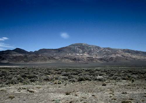
 Big Mountain from the north Big Mountain from the north |  Route Route |  Nearing the top Nearing the top |
Red Tape
The mountain is in a Wilderness area and some old roads are now closed. Obey the restrictions found in a wilderness area and you will be in good shape. More information can be obtained from the BLM ranger in Gerlach.  On the way up On the way up |  Register Register |  Summit cairn Summit cairn |
When to Climb
Most likely this mountain could be climbed during any season but I would avoid it if it is snow covered as the slopes are very steep in places and crampons and ice axe might be necessary. Also avoid the area during times when it is raining (rare)as the roads might become impassable in places due to mud.Camping
You can car camp most places in the BLM but preferably at places where your visit will leave a minimal impact. Camping is offered for a fee at the Soldier Meadows Ranch about ten miles north of Mud Meadows Lake. Gerlach has one small motel if you don't care to car camp.If you would like a meal, you can check in at the ranch and see if they can accomodate you. They did accomodate the two of us and the meals were excellent.

Weather
GerlachSummit ascents

We saw no benchmark or witness markers on the summit area.
Those who have climbed this one:
1997 - Gordon MacLeod and Barbara Lilley
2003 - Bill Hebert
2005 - John Vitz
2007 - Seth Ames
2011 - Brad Boester
2013 - Dennis Poulin and also Rich Wilson and Ron Moe
2014 - Ken Jones and Dean Molen
Summit views
 Our future goals Our future goals |  Looking south Looking south |  Looking north Looking north |
Soldier Meadows Ranch/Burning man
HistoryRanch and Lodge
Access to the ranch
First 12 miles from Gerlach
From Gerlach to Soldier Meadows -part 2
Avoid this area during the "Burning Man" mass meeting near Gerlach. The roads will be clogged and you'll have to contend with unexpected traffic.
Dean - May 3, 2015 7:42 am - Hasn't voted
Soldier Meadows accessI became aware of another report of some others that drove in the way Ken and I did. Their report is less melodramatic than mine (see front page) and makes it more matter or fact. I would still caution you to first walk some of the shelf road that drops down to Piute Windmill and assess the driving conditions for yourself. I personally would not drive it again but that is just me. Ken Jones agrees with me but if you can make the drive, you can cut the elevation gain and distance up the mountain in half. Here's the other report: "We drove up the Soldier Meadows Road to Soldier Meadows Ranch. From there we passed through 3 unlocked gates (after gaining permission from the ranch) and drove up Slumgullion Canyon to Paiute Windmill. Then we continued south and parked near Trough Spring. 1.69 airline miles to the summit with about 2100 feet of gain. The road up Slumgullion Canyon doesn't show on the topo, but I had spotted it on the satellite. The road from Solider Meadows Ranch onward is rough in spots but easily passable in 4 WD / High Clearance." Ken was driving a 4 runner, I was driving a Tacoma pickup and the party mentioned above was driving a GMC Envoy. After we came back from our hike of Big Mountain, a ranch hand we met at the Soldier Meadows ranch told us he turned around on an ATV before the drop down to Piute Windmill because it was scaring his dog."