
-
 12885 Hits
-
 87.2% Score
-
 24 Votes
|
|
Mountain/Rock |
|---|---|
|
|
61.04923°N / 149.09941°W |
|
|
Hiking, Scrambling |
|
|
Summer, Fall |
|
|
4850 ft / 1478 m |
|
|
Overview
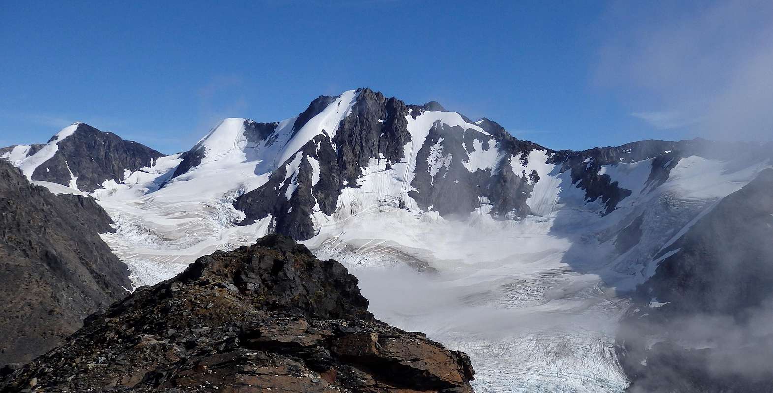
 Views from the pretty approach hike. The mountain in the distance is Raggedtop.
There is quite a bit published about this peak, but much of it is wrong or misleading. This page is an attempt to improve the quality of information available to the large number of hikers who converge on Crow Pass.
Getting There
 A goat on the S Ridge
Routes
 The green line shows the off-trail portion of the NE Ridge route; the orange line shows the off-trail portion of the S Ridge route.
There are several variants of the Crow Pass Trail heading up the valley toward the nunatak. Regardless of which trail branch you are using, after about two miles of hiking from the trailhead (and 1400 feet of ascent) you'll pass the throat of a gorge in which Crow Creek goes over waterfalls. Just beyond the throat, leave the trail where the east branch of Crow Creek actually crosses your trail, the first and only significant stream crossing on way to Crow Pass. (The east branch splits in two above the lowest variant of the Crow Pass trail; for purposes of this description, ignore the smaller tributary and focus on the main east branch). Head east-northeast, using ledges or scree to pass the small cliff band over which E branch cascades, and enter the large scree/snow bowl between the nunatak and Jewel. Walk all the way back along the main stream until you reach the saddle behind the nunatak, and then turn to climber's right and make a short, easy scramble into the higher bowl containing south lobe of Jewel Glacier (almost a stagnant ice remnant now). Skirt this easily along its left margin, angling into the broad tundra pass between Jewel and the peak to its north. In early summer this is a traverse of snowfields on left of the "glacier," but no ice axe or glacier travel precautions will be called for. In late season you'll be mostly on moraine and scree.
At the pass, views open up over Milk Glacier and beyond. Ascend the last 400' on the class 2 northeast ridge to Jewel's summit. The four mile, 3250-foot climb from the Crow Pass Trailhead takes 2-4 hours. The route is mapped on a bird's eye photo here
In making this ascent, stay off the larger north lobe of Jewel Glacier (the part that's under Summit Mountain). You shouldn't be tempted to go over there, since it's seriously off-route, but I feel I have to warn you since that part of the glacier has significant hidden crevasses.
 The east branch
Summit Views

Red Tape
Jewel Mountain sits entirely in Chugach National Forest, not in Chugach State Park. There is no parking fee at the trailhead. There aren't any rules that will restrict reasonably responsible users. Don't mess with or deface the historic mining ruins.Camping
Backcountry camping would be possible in the bowl between the nunatak and Jewel that northeast ridge hikers will pass through shortly after leaving the Crow Pass Trail. Although arduous to reach, there are also spectacular campsites in the Jewel-Summit Mountain pass, 400 feet below the top of Jewel.Cautions
The Crow Creek canyon, traversed by the Crow Pass Trail as it approaches Jewel, is prone to winter and early spring avalanches. This risk should recede by sometime in May. There are some bears (both grizzly and black) in the area, so that it is a good idea to make some noise and carry bear spray while hiking in the brush.The Mines on Jewel Mountain
 Remains of the Monarch Mine. This item is probably a hydraulic ram pump.
Nearby Peaks
Barnes Mountain, a pleasant crest on Jewel's south ridge, is class 2 from almost any angle. It provides a nice consolation prize for anyone who finds the intimidating appearance of the upper south ridge a little too daunting.Cabin Peak (also called Crystal Point) is a nice peaklet with about 200 feet of prominence near Crow Pass and BM 3883. Its 4400-foot summit is class 2 via its east ridge, and is just high enough to give some long views, north and south, though they don't quite match those on Jewel.
Summit Mountain is a 5300-foot summit to Jewel's north that looks like a hop and a skip, an easy second peak to bag on an ascent of Jewel from the north side. In fact, however, the most reasonable route over to Summit will funnel you onto the upper north lobe of Jewel Glacier, a portion of the glacier that--although it can look benign--actually does have a surprise crevasse or two. Don't go over to Summit unless you're equipped for this.
Links
Letter with historical information from Brigadier General Bruce Staser (1919-2010), son of Harry Staser.Chugach National Forest Brochure
Crow Pass Trail guide (by Alaska Department of Natural Resources, or DNR)
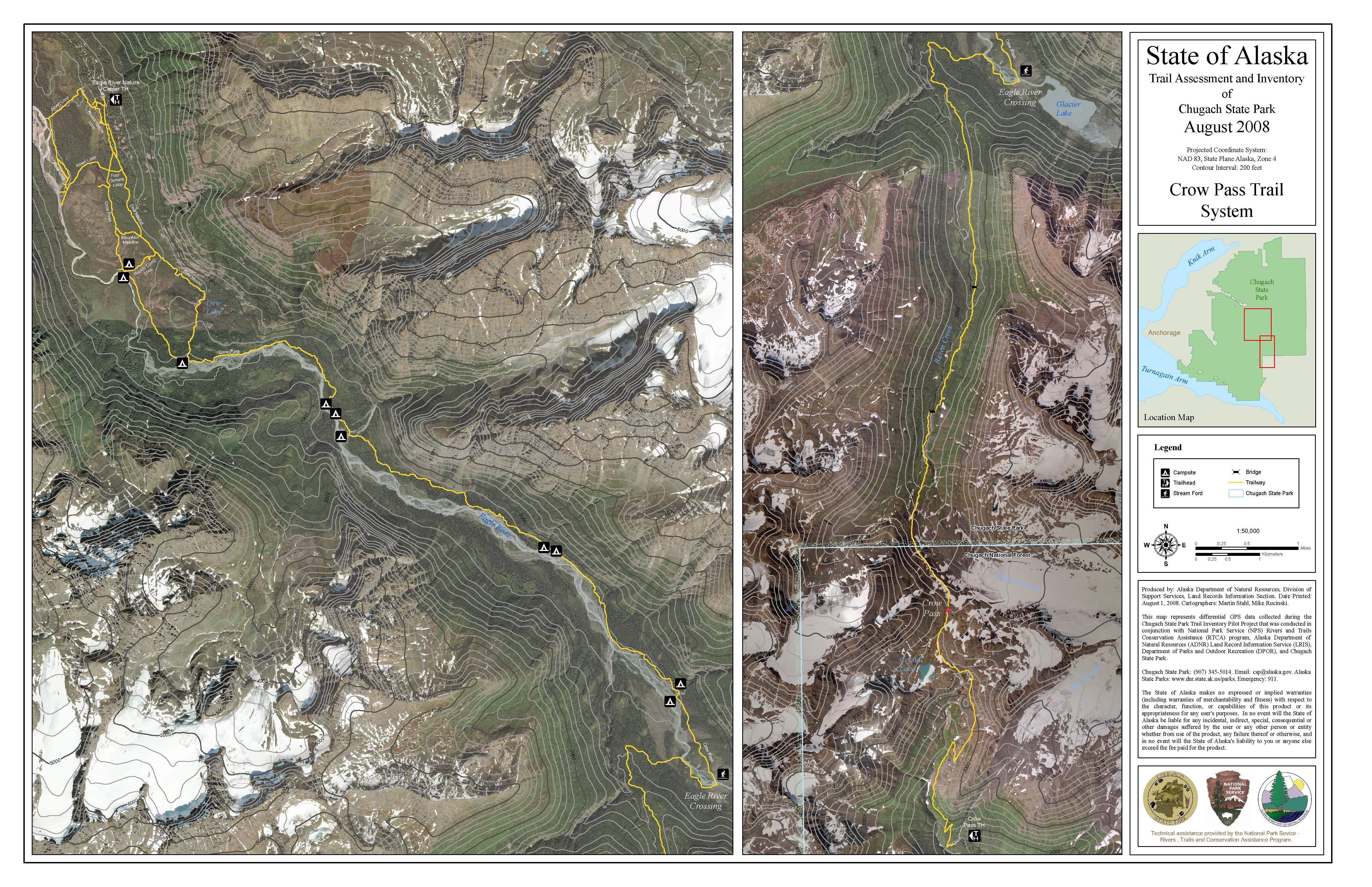
DNR's map of the trail (blows up well for excellent detail)
Iditarod National Historic Trail
Description of initial portion of Crow Pass Trail (by Alyeska Resort)
|
|


