
-
 12548 Hits
-
 91.45% Score
-
 35 Votes
|
|
Mountain/Rock |
|---|---|
|
|
46.45556°N / 11.62013°E |
|
|
Trentino Alto Adige |
|
|
Mountaineering, Trad Climbing, Big Wall |
|
|
Summer |
|
|
9780 ft / 2981 m |
|
|
Overview
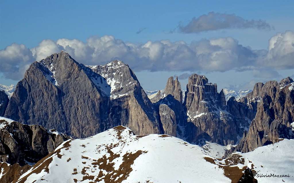
Geographical classification: Eastern Alps > Dolomites > Catinaccio Group > Catinaccio – Rosengartenspitze
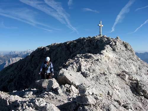
Catinaccio – Rosengartenspitze 2981 m
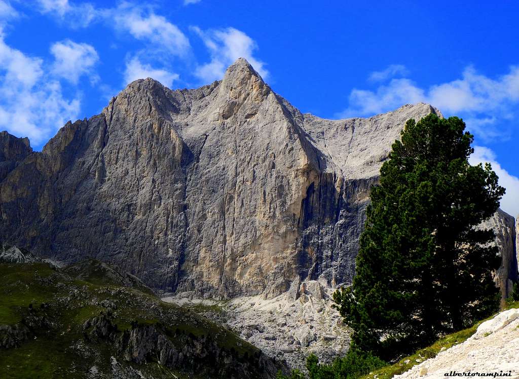
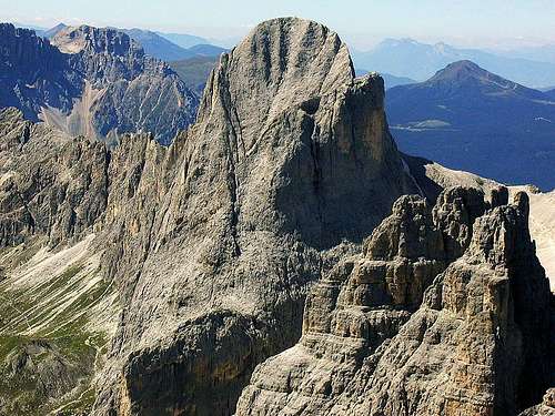
Cima Catinaccio 2981 m is a complex and famous peak of the Dolomites, the most important one of the namesake Catinaccio massif, a group belonging to the Western Dolomites and located on the watershed between the Val di Tires (Bolzano Alto Adige province) and the Val di Fassa (Trento province). The Catinaccio group is an Imposing massif that dominates the Fassa Valley with the villages of Vigo, Pozza and Mazzin and the Val di Tires. Cima Catinaccio dominates the Gardeccia Basin with its stunning East Face, probably the finest wall of the whole massif. The lower West wall, where it runs the Normal route to climb the peak, dominates the superb Gartl basin, with the Refuge Re Alberto I, and faces the famous Torri del Vajolet. Cima Catinaccio is also called "Ciadenàc" in ladin dialect, which means mountain basin, debris, a name deriving from the two gigantic rocky basins located in the upper part of the East wall, and "Rosengartenspitze" in German, name evoking the legend of King Laurino and his “roses’ garden”.
Catinaccio is the second highest summit of the group, after Catinaccio d’Antermoia, this latter being the only summit in the group exceeding the 3000 meters. Apart from the altitude, anyhow Catinaccio is the most powerful rocky structure of the whole group, a huge and extended blade, lying in the Western sector, just in front of the famous tryad of Vajolet Towers and South-East to Croda di Re Laurino. Catinaccio has two fore-summits: the Northern one 2911 m, near Punta Emma, and the Southern one 2913 m, overlooking the Forcella Sud del Catinaccio, this latter separating the mountain from Cresta di Davoi.
The most impressive and high face is the steep and stunning East wall 600 meters drop and about 900 meters long, overlooking the green basin of Gardeccia. The summit of Catinaccio, a mountain which is mainly the domain of stunning walls and difficult climbs, can be reached along a low-level route running on the West wall and frequently attended. See the complete Normal route-report below in the chapter n. 5.
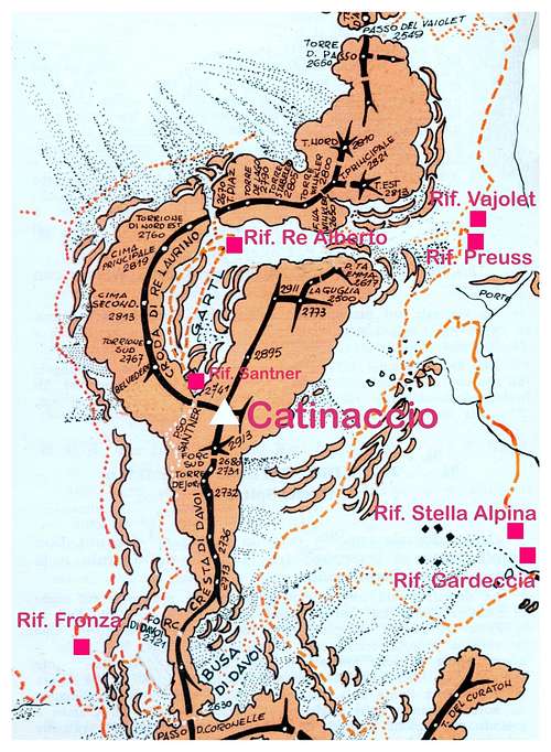
Getting There
The starting points to approach the mountain are Pera di Fassa, located in the homonymous Val di Fassa, or Passo Nigra, Val di Tires
Road access
- from Trento follow the Brennero Motorway towards North, exit Egna-Ora and take the road S51 towards Fassa Valley, getting to Cavalese, Predazzo, Moena and Pera di Fassa (48 km. from Egna-Ora). The road from Pera di Fassa to Gardeccia is open to private vehicles as far as the little hamlet of Soial. A minibus service is available from the chair-lift station in Pera di Fassa; frequent departures both from Pera and Gardeccia. Otherwise the chair-lift will lead you to the upper station (rif. Ciampedie), 40 minutes by walk to reach Gardeccia
- from Bolzano follow the Brennero Motorway towards North, exit Prato all’Isarco and take the road to Tires and Passo Nigra. Before getting to Passo Nigra you reach the Coronelle chair lift station, that rises to Rifugio Fronza alle Coronelle, a good starting point to Passo Santner shelter and the routes of Catinaccio West Face, located just in front of the shelter (Via Ferrata, 1,15 h from Rif. Fronza to Rif. Passo Santner).

|

|
History
First ascent
The first summiters were the British C. Tucker e T. H. Carson with the guide François Devouassoud in the year 1874.
Faces and routes
Catinaccio is a fine and complex summit showing different climbing sides. It counts overall about 70 routes.

East face
It's a superb and mighty wall overlooking the basin of Gardeccia, 600 meters high and about 900 meters long, characterized by two huge bowls. An aesthetic wall that attracts the eye and is therefore highly coveted. There are numerous climbing lines.
East wall main selected routes from left to right - UIAA scale
- Via Kiene D-, 600 m. - H. and K. Kiene, summer 1909 -
- Via Dimai D-, 600 m. - A. Dimai, A.J.S. Raynor, J.S. Phillimore 1896, August 24th - An old style classic route
- Via Fantasia TD-, 600 m. - A. Bernard and M. Vigo 1991, August 18th - Fine route
- Via Steger TD-, 600 m. - H. Steger, F. Masè Dari, S. Lechner 1956, August 27th - A stunning line, one of the greatest classic routes of the Dolomites. Can't be missed!
- Via Leviti-Nemela ED-, 600 m. - A. Leviti and I. Nemela, 1973 August - A great challenging route

- Via CAI Alto Adige TD, 600 m. - S. Barbacetto and A. Giambisi, 1966, june - A spectacular exposed route, both artif and free climb
- Via del Nostromo ED-, 410 m. - M. Petronio and G. Bressan 1988, August 13rd - Another challenging route
- Passeggiata sui neri TD+, 220 m. - M. Giordani and Rosanna Manfrini 1985, July 21st - A free climbing classic route, few equipped
- Via Olimpia TD-, 250 m. - B. De Francesch and Q. Romanin, 1960 September
North Face
It's a compact yellow wall culminating in the Northern foresummit and dominating the rocky gully leading to the Gartl basin and Torri del Vajolet
North wall main selected routes from left to right - UIAA scale
- North-East Ridge PD+, 400 m. - O. Ampferer and C. Berger 1899, August 3rd - A good alternative to the Normal Route
- Via Solleder D+, 260 m. - E. Solleder and F. Kummer 1926, August 29th - An interesting classic climb
- Via Piaz TD-, 260 m. - G.B. Piaz and V. Dezulian 1928, August 29th - One of the best climb of the Northern Face
- Via Ingrid TD+ (ED all free climbing), 280 m. - P. Schubert and W. Pecher 1961, September 8-9th - Rarely frequented, but interesting challenging route
- Via Vinatzer-Peristi TD-, ED- entirely free climbing, 280 m. - G.B. Vinatzer and V. Peristi 1935, July 26th - An ideal direct line running on the impressive and steep NW wall; a satisfactory route, notwithstanding the quality of the rock, not always good
West Face
It consists of a long rocky wall with a height ranging from 400 to 150 meters, facing to Croda di Re Laurino and Torri del Vajolet and dominating the Re Alberto and Passo Santner shelters and the Gartl basin.

West face main routes from left to right - UIAA scale
- Normal Route PD, 250 m. - F. Devouassoud, C. Tucker and T.H. Carson 1874, August 31st - An amusing easy climb on solid rock, see the route report in the next chapter
- Via Piaz-Delago D-, 180 m. - G.B. Piaz and H. Delago 1912 - Interesting route, one of the best on the Western wall
- Via Mariangela
South Face
It consists of a craggy ridge, rising from Forcella Sud del Catinaccio 2680 m
- South ridge AD, 350 m. - J. Santner and G. Merzbacher 1887, July 31 - A classic climb of low difficulty

Descent: following the Normal route on West face
Descent report: from the summit follow the numerous cairns along the ridge, reaching a first anchor. Do a 20 meters abseil and continue along the ridge, reaching another fixed anchor, placed near a notch. Five abseil from about 10-30m lead to the basal scree, a few minutes from the Rifugio Santner. From here to the Re Alberto Hut and Vajolet Hut
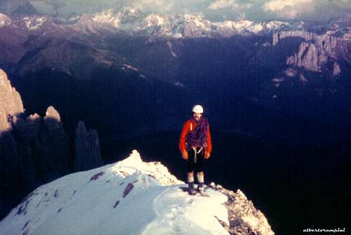
Catinaccio Normal Route report
Catinaccio Normal Route report
Summit altitude: 2981 m
Difficulty: PD, III UIAA
Equipment: belays equipped with cemented anchors
Climbing length: 250 m Exposure: W First ascent: F. Devouassoud, C. Tucker and T.H. Carson 1874, August 31st
Starting point: Rifugio Passo Santner 2741 m
Even though it is the Kingdom of stunning walls and difficult climbs, the Catinaccio can be reached along a low-level route running on the West wall. It's a frequently attended route on good rock though somewhat polished.
Approach
The starting point is the Rifugio Passo Santner m 2741, which can be reached either from Gardeccia (Val di Fassa) across Refuge Vajolet and the Gartl Basin with the Refuge Re Alberto (1.30 hour) or from Rifugio Fronza (Val d'Ega, reachable from the chairlift from Malga Fromm) via the Ferrata Passo Santner (1.15 hour). From the Rif. Passo Santner it appears to the left the beautiful West wall of the Catinaccio. The start of the route is at the base of a narrow chimney located at the end of a gully coming down from the lower fork along the summit ridge. It facilitates the finding of the attack a small white tombstone just above the chimney, clearly visible from the hut.

Route report
L1 - Climb the chimney, overcoming after 5 m a polished bottleneck. A few meters above the chimney widens and leads to the first belay on the bottom of the gully, III, II. L2 - Up the gully, when it starts steep again exit the left-hand side on easy steps up to a stance with a cemented ring, II. L3 - Slanting left on easy rocks, up to get the base of a nice wall, below which there is a comfortable stance, II. L4 - Climb the wall on fine rock and after 15m you come back on sight of the chimney-gully coming down from the notch on the crest. Shortly before getting the chimney-gully there is a belay with 3 pegs, II+, 25 m L5 - Up a few meters to the bottom of the chimney-gully, cross it, then then up to the notch climbing a nice slab with holes, III, II. Belay on the notch. Follow easily the airy crest getting a notch below a steeper stretch. Up a sloping dihedral, then the ground becomes easier on fun rock,leading to the summit cross with the summit book.
Descent: reversing the route (downclimb on the summitridge to the notch, then 4 abseils from the notch to the start)
Natural parks
Cima Catinaccio is located inside the Natural Park Sciliar-Catinaccio and Latemar. This area, shared between the provinces of Bolzano and Trento, is one of the nine mountain systems of the Dolomites acknowledged as UNESCO World Heritage Site. It is one of the most important systems worldwide for the study of the stratigraphy of the Triassic, in reason of the plenty of fossils on Alpe di Siusi, the relationship between carbonate and volcanic sediments, and the fact that the outcrops are easily accessible.

Catinaccio, with the stunning Vajolet Towers, forms a series of peaks and sharp needles showing the movement of an island which sank into the sea 240 million years ago. More info about Dolomiti Unesco World Heritage can be found here:
- in the article by Silvia Mazzani: Dolomites living mountains
- on the Unesco Official web-site: Unesco
- on the Fondazione Dolomiti Unesco web-site: Fondazione Dolomiti Unesco
Red Tape
No particular restrictions in climbing and hiking. The road starting from Pera di Fassa to Gardeccia is open to the private cars as far as the small hamlet of Soial. Private cars beyond Soial are not allowed.

Huts
- Rifugio Gardeccia 1949 m. Situation: Gardeccia basin Open: from June to the end of September - from Christmas to Easter open during the day (no overnight) Size: 43 persons Getting There: by walk from Soial, alternatively by minibus from the chair-lift station in Pera di Fassa Phone: 0039 0462 763152 Mobile: 0039 335 7432677 - 0039 335 7432676

- Rifugio Stella Alpina Situation: Gardeccia basin Size: 50 persons Getting There: by walk from Soial, alternatively by minibus from the chair-lift station in Pera di Fassa Hut's phone : 0039 0462 760349

- Rifugio Vajolet 2243 m, SAT Trento - Rifugio Preuss 2243 m

- Rifugio Re Alberto 2621 m. - Rifugio Passo Santner 2741 m.

- Rifugio Fronza alle Coronelle 2337 m., Provincia Autonoma di Bolzano
When to climb
The best season to climb goes from June to September
Guidebooks and maps
-Guidebooks


- "Arrampicare sul Catinaccio e dintorni" by Mauro Bernardi, Ed. Athesia, 2013
- “La nuova guida del Catinaccio” by Antonio Bernard, Ed. Mediterranee, 2008 – A wide selection of the Catinaccio group climbing routes
- "Arrampicare Dolomiti Nord-Occidentali
- “Catinaccio” by Dante Colli and Gino Battisti, Tamari Editori in Bologna, 1984
- "IV grado Dolomiti Occidentali" vol. I by Emiliano Zorzi, ed. Idea Montagna 2011
- "IV grado Dolomiti Occidentali" vol. II by Emiliano Zorzi, ed. Idea Montagna
- Maps
Rosengarten-Catinaccio Latemar - 1:25.000 sheet - Compass
Val di Fassa e Dolomiti Fassane - 1:25.000 - sheet 06 - Tabacco
Meteo
METEO TRENTINO
DOLOMITI METEO - TRENTINO
METEO BOLZANO