
|
|
Mountain/Rock |
|---|---|
|
|
40.53580°N / 118.97896°W |
|
|
Pershing |
|
|
Hiking |
|
|
Spring, Summer, Fall |
|
|
6988 ft / 2130 m |
|
|
Overview
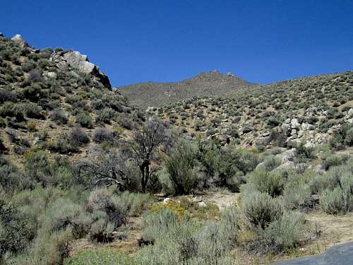
Hannan High Point from trailhead
If there is a black hole for information about an area in the continental United States, it is the area where this high point is located. I have looked everywhere for information about the Hannan range and particularly about the history of the area but I keep ending up with a big blank. I don't know who this range was named for and I can't find anything about the mining or ranching history. The only thing I could come up with is that the Applegate-Lassen trail went through Rabbit Springs which is 20 miles to the north. Still, this make me wonder about the background of this area otherwise and so if you are a reader of this that has anything at all about this area, please email me. On the topo map, I did see one old mine called the Twin Buttes mine on the west side but that was it.
Here's what I do know. While the Hannan range is one of the most isolated ranges in Nevada, it does receive more visitation now thanks to the interest
hikers/climbers are developing about the peaks in Nevada that have over 2000 feet of prominence. When my friend Dennis Poulin signed into the register that was placed in 1999, he said there had only been five others that had signed in the 12 intervening years (he was there in 2011). Since then an additional 10 people have made the pilgrimage out to this lonely summit which includes three from Dripping Springs Texas.
With just over 2000 feet of prominence, this one comes in at #163 on the Nevada list which puts it close to the bottom. Due to the distance from Lovelock or Gerlach, it is wise to add a visit to the Seven Troughs summit and maybe Black Mountain or Juniper Mountain while out there. During our time out in the area, we saw but one other vehicle and that was at the Seven Troughs pass when we were making our way in. A lot of wild burros greeted us however so the area isn't without a welcoming committee.
Getting There
Since the easiest way to approach this one is from Lovelock and I-80, I will provide directions from there.From Lovelock
I-80, exit 106 in Lovelock.(Remember that odometer readings may be slightly different for you) Take Main St west about .5 mile to N. Meridian and turn right. I went north on N. Meridian about 1.5 miles to Pitt Rd (NV 399). This is a good paved road heading west. At about 11.7 miles turn right on a good dirt signed Seven Troughs/Sulfur road.
In about 4.7 miles on this road take the left fork (signed) and in another 3.3 miles or so, the road takes a sharp left and heads toward a pass in the Seven Troughs Range. On the other side of the range at about 19+ miles from NV 399 I passed a corral on my left and in another 1.5 miles I turned right on an unsigned road that headed north up the Hannan/Seven Troughs valley. Please study your Benchmark mapbook pages 47 and 39 for more help if you need it. Now it is straight up the valley between the Hannan and Seven Troughs ranges for almost 6 miles. Reaching a fork, the left branch goes toward the Hannan range and the right fork drops down into a big wash and will head to the Seven Troughs peak area (see Seven Troughs SP page for more information). Taking the left fork, it is about 2.7 miles to where you find a short spur road leading to Hanna Springs. This is the trailhead.

The trailhead

Route map
Route
We started hiking west past the springs via the ravine past and found the first little bit brushy but it soon opened up. After 300 yds or so, we came to where 2 forks in the drainage came together. We headed straight up at this point and went directly up the slope which led to another slope and then a ridge that leads towards the summit. Basically it is easy although often steep hiking in open country with small brush to deal with and at one place where it levels out, a lot of quartz rocks litter the ground like we had never seen before. Just after the quartz crystal area, there is a little dip and then its up the next slope to a little higher ridge. The summit is off to the right on a rocky protrusion. It is never difficult but having a GPS bearing on the summit is a big help if you find yourself confused on the ascent up.  Heading up Heading up |  Steep slope Steep slope |  Summit ridge Summit ridge |
The summit itself is atop a large rock formation and I found a class 3 spot to gain the summit although I found an easier way down which would probably be just a high class 2. Again, nothing difficult. Near the summit Richard found the glass bottle register and we signed in and took a breather for a few minutes to enjoy the scenery. Surprisingly, I had texting capability with my Verizon phone from here so I was able to let my wife know where we were and what our plans were for the next couple of days. Round trip: less than 4 miles and a bit over 1700 feet of elevation gain.
 Richard Richard |  Summit Summit |  Old register Old register |
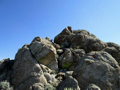
Class 3 to summit
Red Tape and weather
None that I am aware of, this is on BLM land. For more information, contact the BLM office in Winnemucca Nevada.BLM Winnemucca District Office
5100 E. Winnemucca Blvd. |
Winnemucca NV 89445 |
Phone: 775-623-1500
Office Hours: 7:30 am - 4:30 pm M-F
Lovelock Nevada weather
When to Climb and views from the top
It is possible that you could visit this area in any calendar month but that would mean you'd have to pay attention to the weather report and avoid the area when its snowing or raining. Also, if it has snowed and left an accumulation, I'd recommend that you wait until spring or fall. Summer can be brutally hot so it is best to consider that before heading out that way. If you do, take plenty of water with you.  Looking north Looking north |  Southwesterly Southwesterly |  East to 7 Troughs East to 7 Troughs |

South to Black Mountain
Camping
There are no campgrounds in this area but since it is on BLM land you can camp just about anywhere. It is strongly recommended that you use the "leave no trace" ethics and pack out any garbage you may have and try to leave the place you camp at in as good a condition as you found it. Motels are available inLovelock, Winnemucca or the Reno - Sparks area.
Special Thank you
Thanks have to go to Dennis Poulin for sharing his information for this mountain on peakbagger.com Historical links
While I haven't found anything that is about the Hannan range area, there are a couple books which will add to your appreciation of those early pioneers who braved the difficult wagon trails of the area.First, to get an overall feel, I highly recommend the book called "The Hard Road West" by Keith Heyer Meldahl. It reads like a novel and made me appreciate those who went before.
Another good source of information is the book about The Applegate-Lassen cutoff. It is this cutoff that went to the north of the Hannan range area and Rabbit Hole Springs was an important part of the use of the cutoff. The book is called "A Guide to the Applegate Trail - From Lassen Meadows to Goose Lake" by Richard Brock and Daniel Buck. Those are both available at the California trails Interpretive center west of Elko Nevada as well as Amazon. Good reading and an eye opener about what it took to get from one place to another.