
-
 14085 Hits
-
 76.48% Score
-
 7 Votes
|
|
Mountain/Rock |
|---|---|
|
|
45.55303°N / 63.22343°W |
|
|
Colchester |
|
|
Hiking |
|
|
Spring, Summer, Fall, Winter |
|
|
1204 ft / 367 m |
|
|
Overview
Nuttby Mountain 1204’ 367 m is the high point of mainland Nova Scotia. The highest point of the Canadian Province of Nova Scotia is remotely located White Hill on Cape Breton Island. Nuttby Mountain is not remote. Just 3.5 kilometers from the nearest paved road, a maintained gravel road passes close to the summit.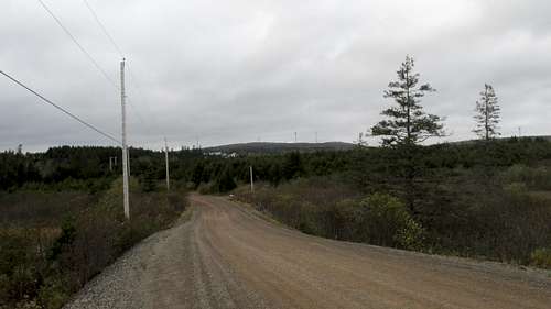
Nuttby Mountain from intersection of Old Nuttby Road & Hwy 311
Nuttby Mountain is home to a Wind Farm with 22 wind turbines. Also near the summit is a cluster of telecommunication towers. Formerly on the summit was a Forest Fire Watch Tower removed November 2013. You can still see the remains of the concrete footings of the tower on the summit.
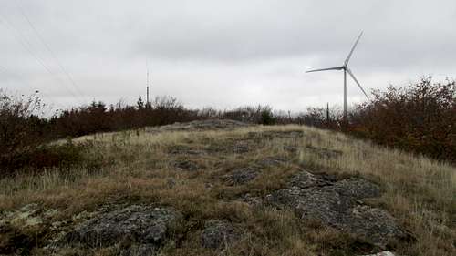
Nuttby Mountain Summit
Getting There
From Halifax, head towards Truro on Hwy 102. From New Brunswick head towards Truro on Hwy 104. From Cape Breton, head towards Truro on Hwy 104. From Truro take Hwy 311 north towards Tatamagouche. The intersection of Hwy 311 and Old Nuttby Road is about 18 kilometers north of Hwy 104. Note, Hwy 311 doesn't have an exit directly from Hwy 104. You'll have to work your way over to Hwy 311 from another exit. Old Nuttby Road is a left turn (west) from Hwy 311. About 2.5 kilometers up Old Nuttby Road is a right turn for Wind Energy Road.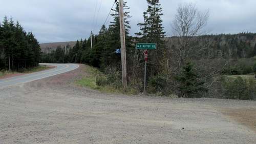
Looking back (south) Hwy 311 from Old Nuttby Road
Nearest Airport: Halifax Stanfield International Airport YHZ 92 Kilometers
Post 9/11, Americans need a passport for Canada travel. On the return trip, US Customs & Immigration is pre-cleared at most major Canadian airports including Halifax. Avoid Toronto Pearson Airport YYZ as your last Canadian airport on the return to the US. I have been stuck in non-moving queues at US pre-clear in Toronto more often than not.
![Nuttby Mountain]()
Intersection of Wind Energy Road & Old Nuttby Road
We chose to park at the intersection of well maintained Old Nuttby Road and steeper but maintained Wind Energy Road. This left us about 300' elevation gain walking about a kilometer up the road. If you choose to walk in from the paved road you will have about 600' elevation gain over about three and a half kilometers. There are designated snowmobile trails on Nuttby Mountain so even in winter you could have packed trail from where ever the plowing leaves off. See my trip report from Oct 14, 2014 for pictures of the route.
Route
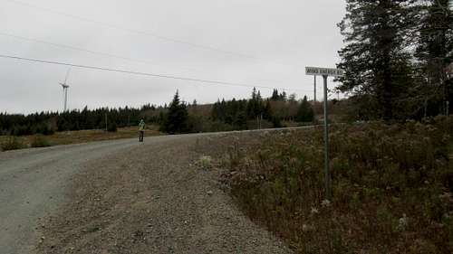
Intersection of Wind Energy Road & Old Nuttby Road
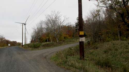
Intersection of old road to summit from Wind Energy Road
Red Tape
There didn't seem to be any access issues for walking up the roads or gaining the summit. The windmills were gated with warning signs for the possibility of falling ice. We did not walk over to the transmission towers so we don't know if that area is fenced.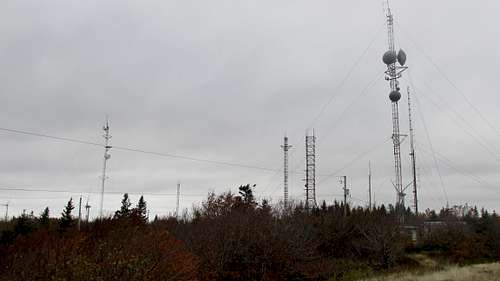
When to Climb
Nova Scotia is usually visited during the summer tourist season. We hiked up Nuttby Mountain during the height of the Autumn colours. Note that as summer transitions into fall a lot of tourist attractions in the area close for the season.GPS Coordinates
WGS 84 UTM Zone 20 Latitude Band T
483933 5041826 lat 45.52979 long -63.20576 595’ 181 m Hwy 311 / Old Nuttby Rd
482631 5043765 lat 45.54721 long -63.22250 887’ 270 m Nuttby Rd / Wind Energy Rd
482626 5043980 lat 45.54914 long -63.22258 988’ 301 m Wind Energy Rd / Old Summit Rd lower
482552 5044192 lat 45.55105 long -63.22353 1071’ 326 m Wind Energy Rd / Old Summit Rd upper
482520 5044394 lat 45.55286 long -63.22396 1163’ 355 m Road near summit
482561 5044413 lat 45.55303 long -63.22343 1186’ 362 m Nuttby SummitExternal Links
CalTopo Map http://caltopo.com/map.html#ll=45.54316,-63.20718&z=14&b=t
Google Map https://www.google.com/maps/@45.5312933,-63.1990104,13z
NTS Map 1:50,000 Tatamagouche 11 E 11 http://www.canmaps.com/topo/nts50/topomap/011e11.htm
Peakbagger http://www.peakbagger.com/peak.aspx?pid=6674
Mountain Forecast: http://www.mountain-forecast.com/peaks/Nuttby-Mountain
Story about the old fire tower that has been removed: http://www.trurodaily.com/Opinion/Columns/2014-01-27/article-3592735/Memories-of-the-Nuttby-fire-tower/1
Nuttby Mountain Wind Farm http://www.nawindpower.com/e107_plugins/content/content.php?content.6657