
-
 7513 Hits
-
 84.27% Score
-
 18 Votes
|
|
Mountain/Rock |
|---|---|
|
|
47.50231°N / 14.93400°E |
|
|
Hiking, Via Ferrata, Skiing |
|
|
Spring, Summer, Fall, Winter |
|
|
7103 ft / 2165 m |
|
|
Topographic isolation: 7 km
Nearest higher peak: Gößeck (2214 m)
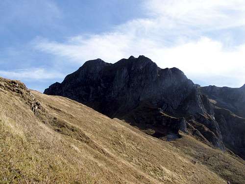
Prominence: 660 m![Eisenerzer Reichenstein]()
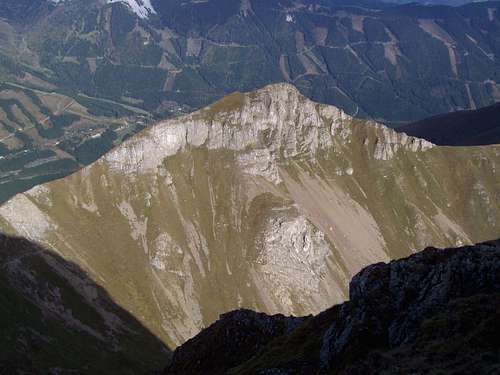
Eisenerzer Reichenstein![Grüblzinken]()
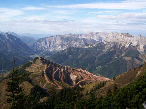
Grüblzinken![Erzberg mining area]()
Erzberg mining areaEisenerzer Reichenstein is a spectacular and very popular mountain in Styria. The prefix ‘Eisenerzer’ is important, because there are other peaks in the Alps with the name ‘Reichenstein’.
The highest peak of Eisenerz Alps is Gößeck. Eisenerzer Reichenstein is a bit lower – but better known.
Why is Eisenerzer Reichenstein so well known and so popular? There can be many answers:
• Easy to get there: the trailhead of the normal route starts at a large and free parking place, and this parking place is only 1 km far from the saddle of Präbichl. The parking place is managed by the small hotel called Präbichler Gasthof
• Various activities: hiking, trekking, via ferrata, skiing
• Spectacular views on the rocky peaks of Eisenerz Alps as well as on the neighbouring ranges
• This mountain also offers the opportunity to visit a huge mine without entering its area
Eisenerzer Reichenstein is a rocky mountain with sharp ridges and with several sub-peaks. The highest peak is the north-east peak. Its height is 2165 meter. This peak is the cumulation of three ridges. The longest ridge stretches to western direction. Named peaks of this ridge are Hieflerkogel, Hocheller and Hohe Lins (2028 m). This long ridge is suitable for ridge trekking
Another ridge is the south-eastern ridge with the peaks Grüblzinken (1990 m) and Vordernberger Zinken (2004 m). The excellent route ‘Grete Klinger Steig’ is along this sharp ridge, including via ferrata sections. There is a deep valley between the western and south-eastern ridge, and you can find a small lake – Krumpensee – and a waterfall here.
The third shorter ridge is to the north, with the sub-peak (1855 m). A part of the Normal Route (Theklasteig) is partially on this ridge. This ridge is adjacent to the Erzberg mining area. This is an open-pit mine, with the largest iron-ore reserve of Austria: 235 million tonnes of ore. Earliest records of mining activity here is from the 11th century. Recently the yearly production is 2.2 million tons. ‘Erzberg’ means Ore Hill. The whole surface of the hill is covered by the mine.
And finally a sentence about the prominence of our mountain: it is the 28th most prominent peak of Styria, and the 2nd most prominent peak of Eisenerz Alps.
![Unnamed subpeak of Eisenerzer Reichensteig]()
This cliff is just above the "Ladder"![Stiege - the Ladder]()
Stiege - the LadderHiking![The Summit Cross of Eisenerzer Reichensteig]()
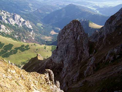
The Summit Cross![Peaks of Ennstal Alps]()
Peaks of Ennstal AlpsThe northern, eastern and south-eastern sides of the peak are almost vertical rock walls. Of course without vegetation. Like the whole Eisenerz Alps, also its highest peak is made from Devonian limestone, consequently it is nearly white, especially in sunshine. The south-western slope is not so steep – the marked trail to the peak is here. ![Pyrrhocorax pyrrhocorax]()
Pyrrhocorax pyrrhocorax![Spring Gentian in October? Yes!]()
Gentiana vernaAlmost the whole area of Eisenerzer Reichenstein is a Natura 2000 nature potection area. Please respect it and keep nature in a condition as it was before your visit![Reichensteinhütte]()
Reichensteinhütte![How do you like the position of Reichensteinhütte?]()
Well positioned...Camping Weiberlauf (480 m a.s.l.)
This is the nearest camping site to Eisenerzer Reichenstein, 27 km from Eisenerz, in northern direction
![Krumpental]()
View of Krumpental
Nearest higher peak: Gößeck (2214 m)
Prominence: 660 m
Overview
Eisenerzer Reichenstein
Grüblzinken
Erzberg mining area
The highest peak of Eisenerz Alps is Gößeck. Eisenerzer Reichenstein is a bit lower – but better known.
Why is Eisenerzer Reichenstein so well known and so popular? There can be many answers:
• Easy to get there: the trailhead of the normal route starts at a large and free parking place, and this parking place is only 1 km far from the saddle of Präbichl. The parking place is managed by the small hotel called Präbichler Gasthof
• Various activities: hiking, trekking, via ferrata, skiing
• Spectacular views on the rocky peaks of Eisenerz Alps as well as on the neighbouring ranges
• This mountain also offers the opportunity to visit a huge mine without entering its area
Eisenerzer Reichenstein is a rocky mountain with sharp ridges and with several sub-peaks. The highest peak is the north-east peak. Its height is 2165 meter. This peak is the cumulation of three ridges. The longest ridge stretches to western direction. Named peaks of this ridge are Hieflerkogel, Hocheller and Hohe Lins (2028 m). This long ridge is suitable for ridge trekking
Another ridge is the south-eastern ridge with the peaks Grüblzinken (1990 m) and Vordernberger Zinken (2004 m). The excellent route ‘Grete Klinger Steig’ is along this sharp ridge, including via ferrata sections. There is a deep valley between the western and south-eastern ridge, and you can find a small lake – Krumpensee – and a waterfall here.
The third shorter ridge is to the north, with the sub-peak (1855 m). A part of the Normal Route (Theklasteig) is partially on this ridge. This ridge is adjacent to the Erzberg mining area. This is an open-pit mine, with the largest iron-ore reserve of Austria: 235 million tonnes of ore. Earliest records of mining activity here is from the 11th century. Recently the yearly production is 2.2 million tons. ‘Erzberg’ means Ore Hill. The whole surface of the hill is covered by the mine.
And finally a sentence about the prominence of our mountain: it is the 28th most prominent peak of Styria, and the 2nd most prominent peak of Eisenerz Alps.
Activities
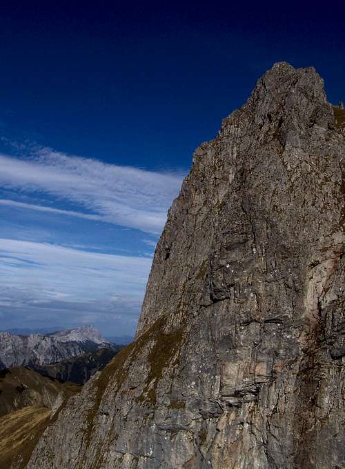
This cliff is just above the "Ladder"
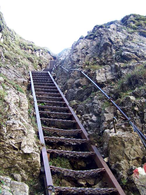
Stiege - the Ladder
- Normal route (Theklasteig): from Präbichler Gasthof (1260 m). Technically no challenge. 4 km distance, 905 m elevation gain. With good view on the Erzberg mining area
- Stiege: this is a variant a Theklasteig. It includes a 15 meter long secured trail section (via ferrata class A/B) and a high ladder. Not difficult, nevertheless in icy conditions I wouldn’t recommend it. There is a vertical rock wall along this route, with a recess in it. This recess can serve as a shelter in bad weather. There is even a bank in it, to make it more comfortable
Trekking
- Weitwanderweg 05 (WWW 05): this is a long-distance trekking route of Austria, in north-south direction from the Czech border to the Slovenian border. This route crosses the mountain of Eisenerzer Reichenstein.It enters the area of Eisenerzer Reichenstein at the Präbich Saddle, and it follows the route of Theklasteig to Reichensteinhütte. From there it is descending to Hafning via the valley called Krumpental. Here you can see also the small lake ‘Krumpensee’ and a waterfall.
- Reichensteinhütte is also the trailhead of a 40 km long trekking route that goes to Admonter Reichenstein (another Reichenstein!). Initially this route goes on the western ridge of Eisenerzer Reichenstein
Via Ferrata (Klettersteig)
Grete Klinger-Steig: This a via ferrata (klettersteig) route on the sharp ridge of Vordernberger Mauern and Vordernberger Zinken. You can start this route either from Hirnalm (934 m a.s.l.) or from the railway station of Vordernberg. This two routes join at Barbarakreuz. Then the route goes further on the ridge of Vordernberger Mauern and that of Vordernberger Zinken and Grüblzinken. The route on this ridge is a long via ferrata route with medium difficulty (class B/C). After this ridge you can get to Rottörl, and there you can decide if to continue the route to the peak of Eisenerzer Reichensteig or to descend to Präbichler Gasthof
Ski Touring
There are a few recommended ski touring routes on Reichenstein. I mention only the route that starts from Reichhals (near Hieflerkogel) and descends to Krumpensee
Skiing
Ski Resort Präbichl is partially on the north-eastern slopes of Eisenerzer Reichenstein
The Peak
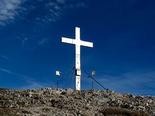
The Summit Cross
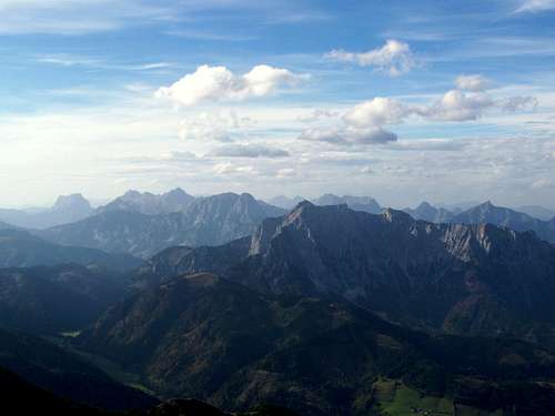
Peaks of Ennstal Alps
A big cross is erected on the summit – similarly to most of the peaks of Austria. There is a smaller flat aera around the cross, so many hikers can stay here in safety and can enjoy the excellent view. The most exposed neighbouring peaks are the following:
- N: Polster (1910 m), Ebenstein (2123 m), TAC-Spitze (2019 m)
- NE: Hochturm (2081 m), Hochschwab (2277 m)
- E: Vordernberger Zinken (2004 m)
- S: Lenzmoarkogel (1991 m)
- W: Reichenstein (2251 m), Ödstein (2335 m), Hochtor (2369 m), Lugauer (2217 m)
- NW: Hochkogel (2105 m)
Red Tape
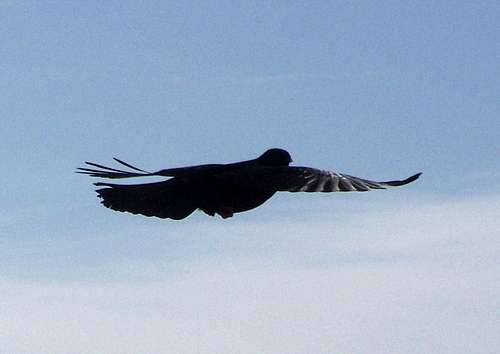
Pyrrhocorax pyrrhocorax
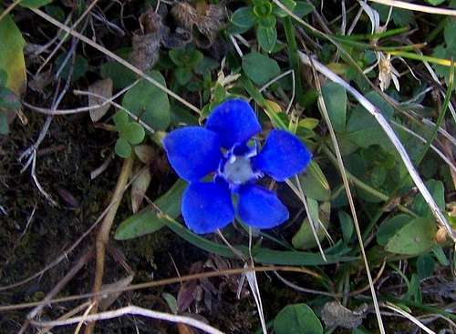
Gentiana verna
Camping and Tourist Hut
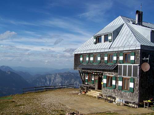
Reichensteinhütte
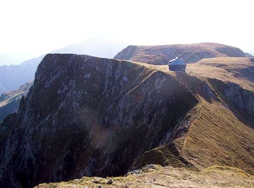
Well positioned...
This is the nearest camping site to Eisenerzer Reichenstein, 27 km from Eisenerz, in northern direction
Website: http://camping-weiberlauf.at/
Reichenstein Hütte (2136 m a.s.l)
It is a historical mountain hut: the first building was erected here in 1898
Website: www.alpenverein.at/huetten/?huette_nr=0184
External Links
View of Krumpental