
|
|
Mountain/Rock |
|---|---|
|
|
37.57880°N / 105.15124°W |
|
|
Huerfano County |
|
|
Mountaineering |
|
|
Summer |
|
|
11569 ft / 3526 m |
|
|
Overview
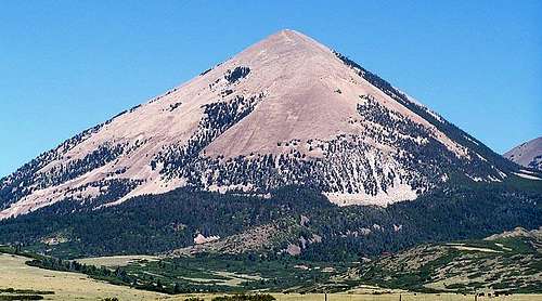
Mount Mestas towers over the surrounding hills.
Mount Mestas is an imposing peak in Huerfano County, lying 3,000 feet over the plains to the east. Although it is very prominent in in area, it hardly receives any visitors, bypassed for the popular Sierra Blanca Massif which is farther west along US 160.
Info about the name: The initial title given to this mountain was "La Veta Peak". However, in 1949 the name was changed to Mount Mestas, in honor of Felix B. Mestas, Jr. who was killed in World War II.
Getting There
Heading south on I 25, reach Walsenburg and turn west (right) on US 160. Continue west for around 25 miles, until you contour past the southeastern face of Mount Mestas. From here, travel for a mile or so until you are right up against the base of the mountain. Here, you are able to park at a small picnic area on the other side of the highway.Route
This peak poses a grueling climb, starting south of the mountain along the highway and slogging northward over 2,500 vertical feet to the summit. The straightforward route is Class 2, but very steep. You will encounter lots of sharp, loose rock, which has to be tolerated starting at treeline.
Starting at the picnic area.
From the picnic area on Abeyta Creek, cross the highway, and head north into the forest. Unfortunately, there is no trail, so you must bushwhack north straight up the south face for 1 mile until treeline, after 1,500 feet of vertical gain. This section will slowly increase in steepness as you continue up the slope. (Note: You may encounter gates while hiking near the base of the peak; BLM states that travelers are able to pass even through closed gates, so don't let them ruin your trip.) From here, the unstable rock really becomes a problem; careful movement is necessary for the last 1,000 vertical feet over 0.6 miles to the summit. A long, flat ridge extends both west and east from the high point, which is adorned with a huge summit cairn. Expansive views of the Sangre de Cristo Range to the west and the plains to the east are amazing.