
-
 12920 Hits
-
 83.32% Score
-
 17 Votes
|
|
Mountain/Rock |
|---|---|
|
|
44.11870°N / 103.8353°W |
|
|
Pennington |
|
|
Hiking |
|
|
6962 ft / 2122 m |
|
|
Overview
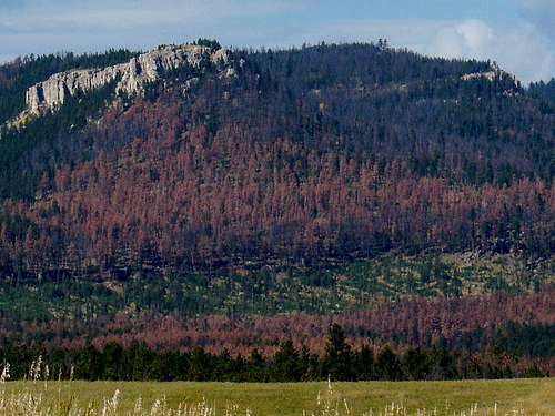 Pine Beetle infestation on the eastern slopes
White Tail Peak is located in the western Black Hills approximately 5 miles west-southwest of the tiny village of Rochford, South Dakota. According to Lists of John the peak is the #9 ranked summit in the Black Hills, at 6,962 feet and with 312 feet of prominence. Even though it is one of the Black Hills highest summits, it is fairly easy to reach the top, due to numerous old mining and logging roads in the area (many unmarked). Because of the thick forest on most of the mountain, views from the summit area are quite restricted. Pine beetle kill has destroyed enough trees in the area that expanded summit views will increase in the coming years. The almost flat terrain at the summit, makes it difficult to find the true high point without a GPS. The Mystic Ranger District, (605) 343-1567, of the National Forest Service manages this area of the Black Hills. Cell phone reception in this area of the Black Hills is spotty at best. Like many of the summits in the western Black Hills and other parts of the Limestone Plateau, part of the mountain is steep while the rest of the sides are fairly gentle. White Tail Peak’s limestone bluffs are predominantly on the east and southeast part of the mountain. While ponderosa pines are prevalent here, one also sees quite a few spruce and aspen trees. There are some oaks and willows along Rapid Creek to the north and North Castle Creek to the south. The creek canyons in the area all provide excellent color in the fall. Forest service officials recommend Road 233 as a route to view large limestone outcroppings and beaver complexes during fall colors expeditions. The North Fork Castle Creek Natural Area lies on the southern edge of White Tail Peak.
History
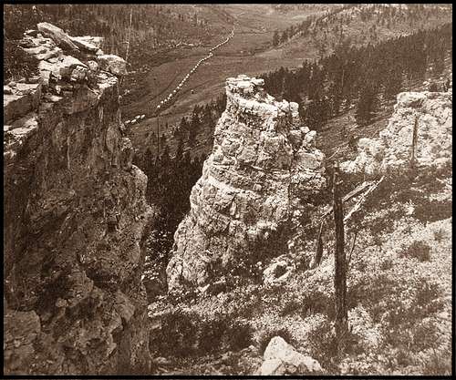 Castle Creek Valley in 1874, with Custer's wagon train traveling through
George Armstrong Custer explored in this area during his 1874 exploration expedition through the Black Hills, traveling down nearby Castle Creek valley. Custer’s photographer on the expedition, W.H. Illingworth, took a photograph of the covered wagon train traveling through the Castle Creek valley. That photograph became one of the most famous glimpses of the expedition and is included in many historical books and collections. A mining town, Black Fox, sprang up in the late 1800’s about two miles to the northwest of White Tail Peak’s summit. What little is now left of Black Fox is an empty ghost town. The Black Fox Campground is very close to that old ghost town. At one time, White Tail Peak was also known as Copper Reef Mountain. The Black Hills Copper Company operated mines on the peak from 1899-1919. Falling copper prices doomed the operation. After the mine closed, all the mine shafts collapsed and there is little left of its brief glory.
Getting There
Forest Service Road 190 (FSR190) passes over White Tail Peak, not far from the summit. FSR190 can be accessed from the east by way of South Rochford Road (between Deerfield Reservoir and Rochford). From the west, FSR190 can be accessed from FSR233, which connects on the north end to Road 231, the South Rapid Road. Rochford is at the east end of the South Rapid Road and Highway 85 is at the west end. FSR233 connects at the south end with Road 110, which leads back to Deerfield Reservoir.
Route Options
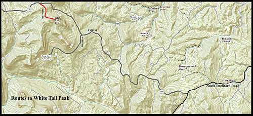 White Tail Peak Route Map
Most hikers to White Tail Peak use FSR190 and one of its branches. The shortest route from FSR190 to the summit is the FSR190.1Q branch, which is about 3.5 miles from FSR233 and 4 miles from South Rochford Road. FSR190 is usually kept in pretty good condition from its junction with FSR233 to the White Tail summit area. However, the section from South Rochford Road to the White Tail summit area if much rougher, mostly only used by ATV’s and snowmobiles.
East Approach: If you want a well-defined route up the steepest side, you can hike the 4 miles from South Rochford Road up FSR190 to the junction with 190.1Q. From there, it is about one-half mile to the summit. If you have a 4-wheel drive vehicle and do not want to hike the whole way, you can park at the junction of FSR190 and FSR190.1A – about 3 miles. This will give you a steep hike to that junction with FSR190.1Q, with an altitude gain of about 500 feet. The half-mile to the summit on FSR190.1Q is pretty easy.
 Road Hazard
Off-Trail Options: Besides bushwhacking to the summit from anywhere along FSR190, you can also bushwhack up from FSR190.1A, which starts on the southeast side of the mountain and winds around to the south side. Also there is at least one unmarked ATV route from this branch to the summit area.
Red Tape
There are no specific prohibitions for White Tail Peak. However, there are the Black Hills National Forest Regulations. Forest fires are always a major concern, so improper or illegal campfires can often bring an unpleasant visit from the nearest ranger.
When to Climb
 Summer Wildflowers
Like all summits in the Black Hills, winter blizzards and deep snow, as well as summer lightning will discourage access. Otherwise, you can access the summit most of the rest of the year. For the latest weather conditions and forecast, click on this link: White Tail Peak – Deerfield Area Weather Forecast & Conditions
Hunting seasons will also be a concern, since this area is open to all types of hunting. Click here to learn more about the South Dakota Hunting Seasons.
Camping or Lodging Choices
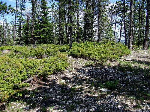 White Tail Peak Summit Area
The greatest concentration of campgrounds in the area is at nearby Deerfield Reservoir. However, the Black Fox Campground is the closest site, just two miles away. For more information, check out the following links:
Black Hills National Forest Camping Regulations
National Forest Service Headquarters Contact Info
Black Hills National Forest Headquarters
1019 North 5th Street
Custer, SD 57730
(605) 673-9200
Maps
The best maps for the area include the Black Hills National Forest Map and the National Geographic Black Hills North map. Both are available at forest service offices in the Black Hills. The free Black Hills Motor Vehicle Use map is also a good resource for back roads.