
-
 6755 Hits
-
 79.61% Score
-
 11 Votes
|
|
Mountain/Rock |
|---|---|
|
|
35.48560°N / 83.815°W |
|
|
Hiking |
|
|
Spring, Summer, Fall, Winter |
|
|
4024 ft / 1227 m |
|
|
Overview
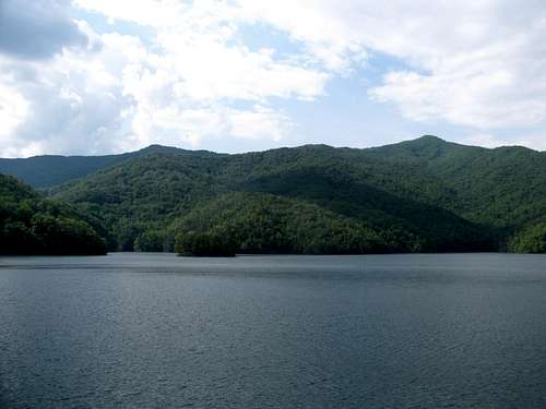
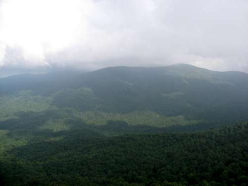
Shuckstack and Twentymile Ridge from Fontana Lake
It may be debatable as to whether or not Shuckstack qualifies as a separate peak. It is a bump off of Twentmile Ridge in the far southern end of Great Smoky Mountains National Park (GSMNP) and does not appear to have sufficient prominence to justify peak status. But Shuckstack does appear on the NPS map for GSMNP, so in the eyes of many, may just qualify as a peak.
Shuckstack is most noted for the firetower that resides on the summit. The views from near the top of the tower are excellent, offering a 360 degree panorama. There appears to be much debate on the internet as to whether or not the firetower is being maintained by the NPS. As of our ascent in June, 2015, my opinion would be yes, and no. The steps to the top were all in good shape and if they have been replaced, it appears it was recent. As for the viewing area, it does not appear that it is being maintained. The floor boards were in very bad shape and I didn’t risk stepping onto them. It also wasn’t completely clear on whether or not all of the windows would open for viewing. Fortunately the steps are in good shape, and other than having to look out past the metal braces, there are good viewing areas in all directions just below the top of the tower.The foundation of the old tower-keeper’s cabin along with the chimney remain at the summit.
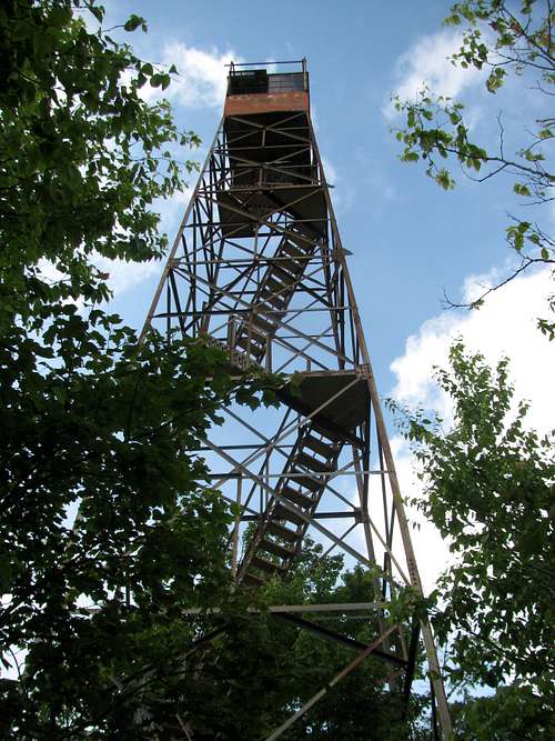 Shuckstack Firetower | 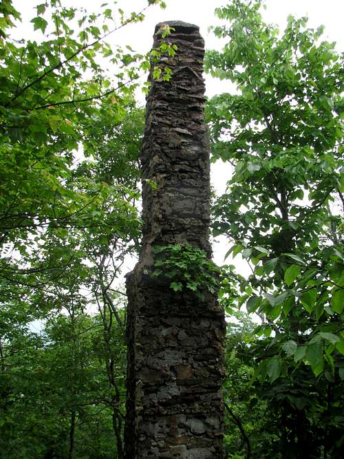 Tower-Keepers Cabin-Chimney |
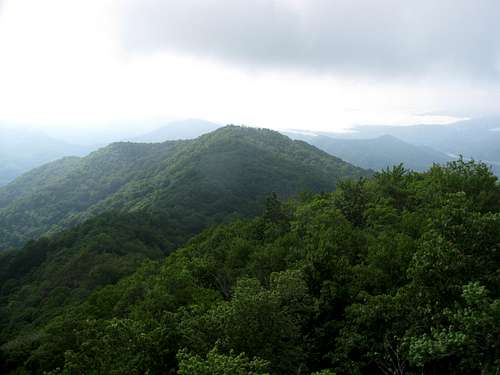
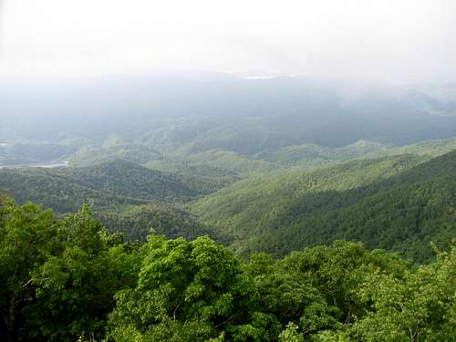
Views from the top include the Unicol Mountains to the west, the Nantahalas to the south, the Blue Ridge Mountains to the southeast and the Smokies to the east and north. Fontana Lake and the inlet to Fontana Dam are visible as well.
 |  |  |
Routes
As with so many of the peaks in the Smokies, due to the large network of connecting trails, Shuckstack can be approached from a number of trailheads, although the most reasonable are either Fontana Dam or Twentymile. Although depending on how many days you wish to spend in the backcountry, route options are numerous. Since the summit resides right off of the AT, approaches are possible from the north, south, east or the west.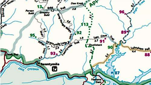
Shuckstack Routes
Standard Route
Fontana Dam Trailhead: The standard approach is from Fontana Dam, and is approximately a 7 mile round trip hike on the AT with approximately 2300 feet of elevation gain. The trail steepens a mile into the hike, with almost all of the gain occurring in the last 2.5 miles. The last quarter mile approach to the crest of Twentymile Ridge is quite steep with approximately 500 feet of gain.
Approximately 3.2 miles from the trailhead there is spur trail at the crest of Twentymile Ridge. From this junction it is about a 0.1 mile hike to the summit and firetower.
Alternate Route
Twentymile Trailhead: The approach from Twentymile Trailhead offers an alternate route with several benefits. While slightly longer, the trail is not as steep, and as Twentymile Trailhead is one of the most remote trailheads in the park, chances for some rare Smoky Mountain solitude increase.
From the Twentymile Ranger Station it is approximately a 10.5 mile round trip hike to Shuckstack with approximately 2500 feet of elevation gain. From the trailhead, it is a 5.0 mile hike to the Appalachian Trail at Sassafras Gap. At the AT trail junction, turn right (south) and hike approximately 0.25 miles to the crest of Twentymile Ridge and the junction of the spur trail to the summit. From this junction it is about a 0.1 mile hike to the summit and firetower.
Twentymile Trail is an old railroad bed, so it is very wide and the grade is quite mild, gaining approximately 2300 feet in 5 miles. The trail hugs Twentymile Creek for the first several miles. Hiking Trails of the Smokies states that there are opportunities to see bears on the trail, and we in fact did see one near the junction with the AT.
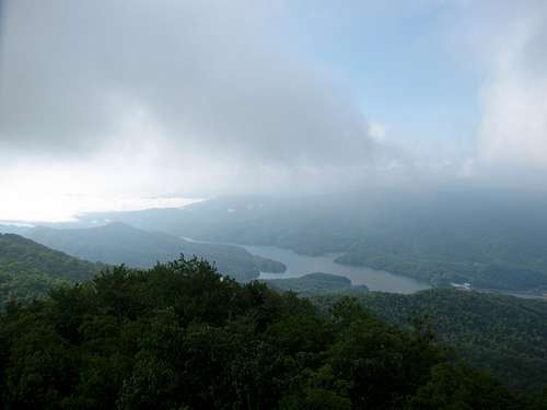
Fontana Lake from Shuckstack
Getting There
Fontana Dam Trailhead: From Bryson City follow NC 28 South for approximately 33 miles to Fontana Dam. The trailhead is 0.6 miles beyond the dam on the right side of the road. Since we did not hike this route, I do not have more specific directions. If anyone can provide more details please provide them in the comment section and I will update the information.Twentymile Trailhead: From Bryson City follow NC 28 South for approximately 39 miles. The road to the trailhead can easily be missed. As can be seen in the attached trail map, there is a sharp curve on NC 28 right at the turn to the road to the ranger station. Turn right off of NC 28 and follow the road passed the ranger station to a small parking area right in front of Twentymile Creek. Just past the parking area there is a small gate at the start of Twentymile Trail.
Red Tape
No permits are required for dayhikes.Backcountry permits are required for anyone staying overnight in the backcountry.
When to Climb
This hike can be completed any season of the year.Camping
Backcountry campsite #93 is located on Twentymile Trail, 1.7 miles from the ranger station.External Links
Frontcountry and Backcountry Camping in GSMNPHiking Trails of the Smokies is a must have for any avid Smokies hiker. This book contains trail descriptions, elevation profiles and usually some historical information on every maintained trail in GSMNP.