
-
 10593 Hits
-
 82.2% Score
-
 15 Votes
|
|
Mountain/Rock |
|---|---|
|
|
44.05220°N / 103.388°W |
|
|
Pennington |
|
|
Hiking |
|
|
4695 ft / 1431 m |
|
|
Overview
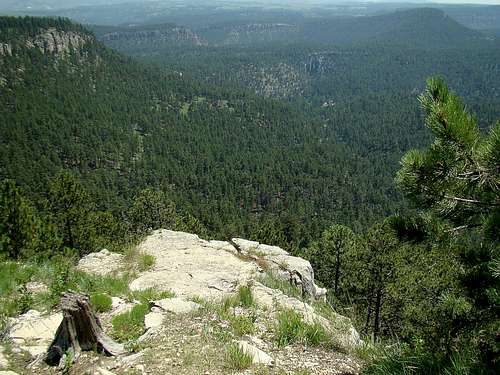 Buzzards Roost summit view of Dark Canyon
A relatively new hiking option near Rapid City, South Dakota, is Buzzards Roost. A new trail network opened there in 2014, with much of the work and financing done by a coalition of mountain bikers, hikers and trail runners. With almost 10 miles of trails, there are many options for hiking here. This summit is listed at 4,695 feet with 378 feet of prominence by Lists of John. However, you will find several area sources that list the summit at 4,720 feet. Buzzards Roost rises about 700 feet above Rapid Creek, which flows along the southern edge of the mountain. The small community of Hisega is located immediately west. The summit area provides some clear views of this area of the Black Hills. Other summits clearly in view include Harney Peak, Scruton Mountain, Thrall Mountain, Boulder Hill, Mount Wheaton and several others. The view also gives a good look at the limestone walls of the Dark Canyon of Rapid Creek. There is supposed to be a summit logbook there, but I had no luck finding it. The forest is managed by the Black Hills National Forest Service. It is apparent there have been some fires on the mountain in years past, as evidenced by small aspens and new growth of ponderosa pines in certain areas. Other parts of the mountain show older and more matures trees. There is an extensive area of wildflowers in the summit area, and the whole area shows evidence of ancient glaciation. Whitetail deer are often seen on Buzzards Roost.
Getting There
There is a small gravel parking area on the south side of Highway 44, around 5 miles west of Rapid City. If you are traveling in from the west, it is about 8.9 miles east of the junction with Highway 385. The parking lot is not huge, but generally there is enough room for the normal traffic on the mountain.
Route
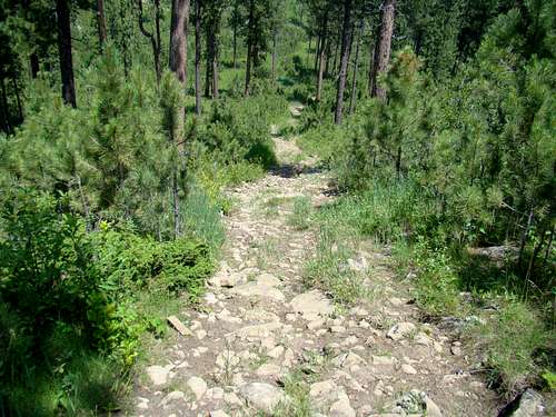 This section of the trail will give you the best burn.
The trail markers here provide the greatest evidence of how much work area mountain bikers have put into the trail development here. Black Hills Trails.org provides a map that gives a pretty good idea of the general layout of the trails on Buzzards Roost. The surest, and probably shortest route to the summit, is to follow the most well-worn path, often marked as the “Jacks Trail”, which is an old two-track road. Eventually, the two-track fades to mostly a single track and the degree of ascent sharpens until you come to another old two-track road. After making a right turn there, it is only a short distance until you come to another junction, where the path to the summit goes south and up to the lookout. From trailhead to the summit, it is probably only about one mile on a mostly-easy trail, with around 500 feet of altitude gain. Normally, you will usually encounter a few other hikers while you are on the trail. A word of caution here… Rattlesnake warnings are posted at the trailhead. Though they are not thick in this area of the Black Hills, the altitude is low enough that they are in the area. Please watch your footing.
Red Tape
There are no fees or permits needed. To avoid trouble, one only has to comply with Black Hills National Forest Regulations. Camping is allowed in the forest around this area, as per regulations. They are particularly strict about campfires, so be sure you are in compliance. Please remember to pack out what you bring in.
When to Climb
 This summit view is toward Mount Wheaton and Thrall Mountain
Spring, summer, and fall are all good times to hike. Winter hikes will depend on snow depth. Of course, summer lightning and winter blizzards will likely mean your hike will have to be re-scheduled. For more on the latest weather in the Buzzards Roost area, click on this link:
Buzzards Roost - Hisega Area Weather
Big-game hunting seasons in the fall will warrant wearing a healthy amount of bright orange. You can learn more about South Dakota hunting seasons at this link:
South Dakota Hunting Season Information
Camping
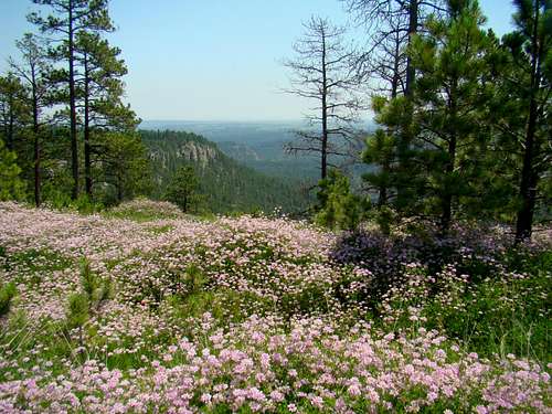 Wildflowers grow in abundance in the summit area
The national forest service has campgrounds in the area, plus the nearby towns of Rapid City, Hill City and Keystone have chambers of commerce that maintain up-to-date listings of campgrounds and lodging. To learn more, click on any of the links below:
Black Hills National Forest Camping
Hill City Chamber of Commerce Camping & Lodging
Keystone Chamber of Commerce Camping & Lodging
Forest Service Contact Information
Black Hills National Forest Service Office
1019 North 5th Street
Custer, SD 57730
(605) 673-9200
Maps
Some really helpful maps for the area include the Black Hills National Forest map, available for purchase at forest service offices. The Black Hills North map, published by National Geographic is also quite useful. And, for the latest on open forest service roads, you can get a free copy of the Motor Vehicle Use Map for the Black Hills, also at forest service offices.