
-
 22896 Hits
-
 86.85% Score
-
 23 Votes
|
|
Mountain/Rock |
|---|---|
|
|
47.58292°N / 121.18279°W |
|
|
King |
|
|
Hiking, Mountaineering |
|
|
Spring, Summer, Fall |
|
|
7291 ft / 2222 m |
|
|
Overview
Dip Top East Face
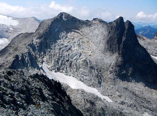
Just north of Mount Daniel and Pea Soup Lake are two peaks of nearly equal height separated by a high col and a dying glacier. If peaks had genealogy, Dip Top and Lynch would be twins. Both peaks have long north ridges with steep west faces and gentler eastern slopes. Dip Top Peak is the higher of the two by roughly 10 feet, thus featuring over a thousand feet of prominence.
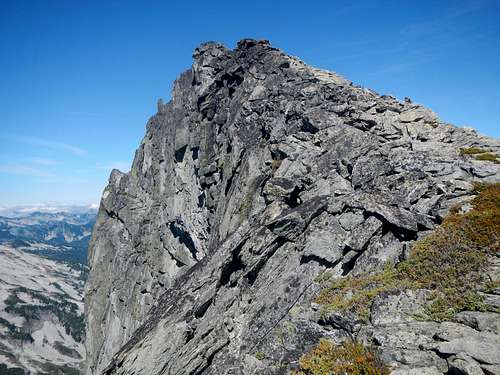
Dip Top West Face
Dip Top was first climbed by Bill Prater and Gene Prater in August of 1950. These two brothers were the first designers of the modern snowshoe in 1970 which made use of modern materials, and included metal cleats. They founded the Sherpa brand which gained great popularity in 1980's setting a new standard for snowshoe production. The west slopes of Dip Top drain into the East Fork Foss River while the east slopes drain into Jade Lake. At 7291 feet, Dip Top Peak is the 7th highest peak on the "Home Court" 100 List.
![Mt. Daniel]()
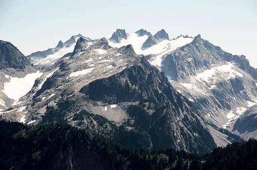
Dip Top North Face and Mount Daniel behind
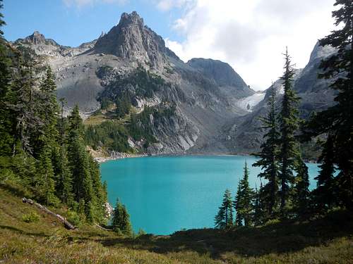
Jade Lake and Marmot Lake are both popular backpacking destinations in the summer, however Dip Top and Lynch are seldom climbed. One reason for the neglect of these peaks might be distance. It's roughly 27 miles round-trip to climb both peaks via the easiest route. Also there is a glacier crossing to consider albeit a benign one. To reach the summit of Dip Top also requires some scrambling on clean granite and a short section of exposed narrow ridge.
![View North From Daniel's Summit]()
Dip Top Peak and Lynch Peak south faces seen from Mount Daniel
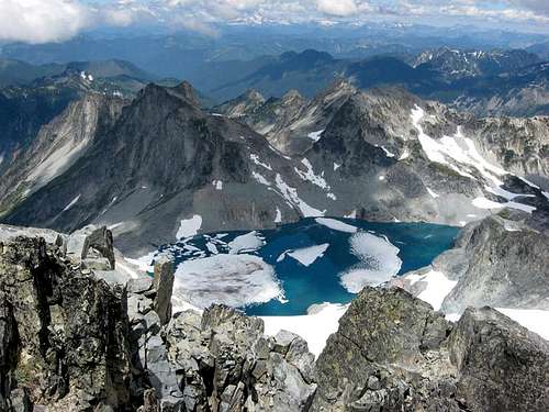
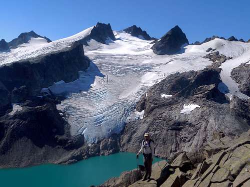
The col between the peaks is known as Dip Top Gap. This high saddle boasts one of the best views in the Alpine Lakes Wilderness and it's no secret. Many hikers make the difficult trek up to Dip Top Gap with no summit bid in mind. The view of the north face of Mount Daniel and the Lynch Glacier rising above the newly formed Pea Soup Lake is jaw-dropping. It's one of those alpine scenes that would fit into nearly any premier mountain range in the world.
Dip Top North Face and Mount Daniel behind
Jade Lake and Marmot Lake are both popular backpacking destinations in the summer, however Dip Top and Lynch are seldom climbed. One reason for the neglect of these peaks might be distance. It's roughly 27 miles round-trip to climb both peaks via the easiest route. Also there is a glacier crossing to consider albeit a benign one. To reach the summit of Dip Top also requires some scrambling on clean granite and a short section of exposed narrow ridge.
Dip Top Peak and Lynch Peak south faces seen from Mount Daniel
The col between the peaks is known as Dip Top Gap. This high saddle boasts one of the best views in the Alpine Lakes Wilderness and it's no secret. Many hikers make the difficult trek up to Dip Top Gap with no summit bid in mind. The view of the north face of Mount Daniel and the Lynch Glacier rising above the newly formed Pea Soup Lake is jaw-dropping. It's one of those alpine scenes that would fit into nearly any premier mountain range in the world.
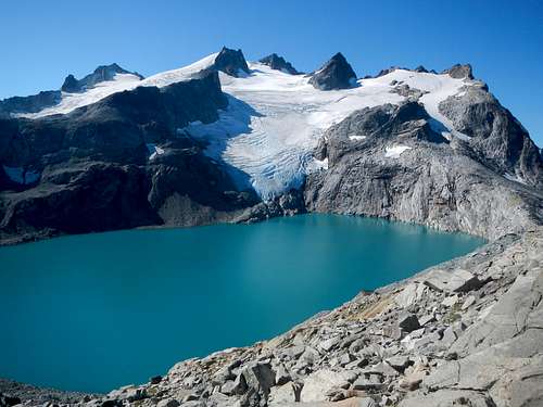
Mount Daniel and Pea Soup Lake from Dip Top Gap
Standard Route
It is mention-worthy that a more difficult traverse route from Mount Daniel exists, however that route will not be described here. Perhaps someone will make a route page at some future time.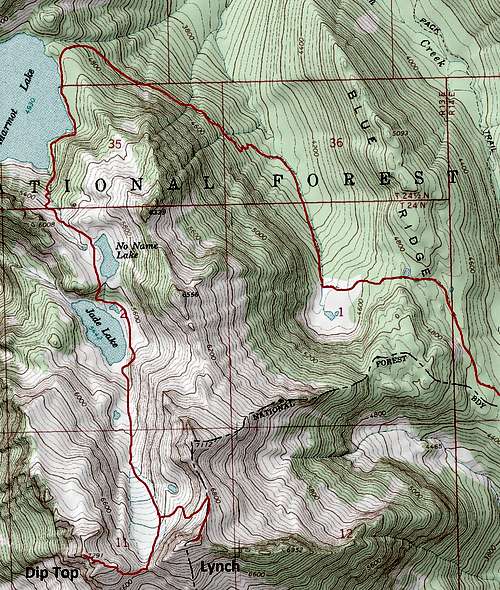
Printable Route Map
Hike north on the Deception Pass trail. Don't get confused and end up starting out on the Cathedral Pass trail. After the first mile you will pass Hyas Lake with numerous camping spots. After the first 4 miles you will pass the Tuck and Robin Lakes spur trail. Just under 5 miles from the trailhead you will come to a 4 way junction at Deception Pass.
Marmot Lake
A sign on a tree will direct you to the Marmot Lake trail. Hike another 3 miles on trail to Marmot Lake. You will pass the Lake Clarice spur trail junction along the way. From Marmot Lake go south following the unofficial trail along east shore of the lake and ascend a steep gully with a talus slope at the top. It's two miles from Marmot Lake to Dip Top Gap. Boot paths and cairns make for easy navigation. Cross the talus to the climbers left-hand side and follow sections of trail up to No Name Lake.
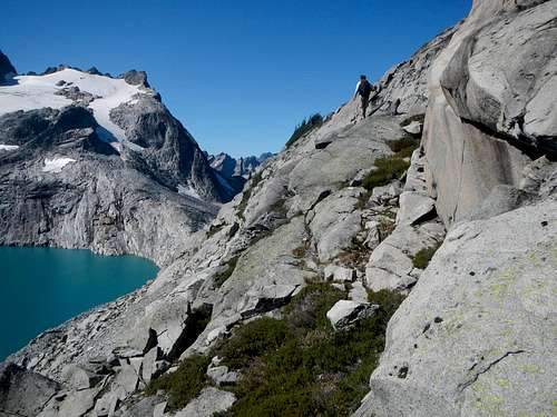
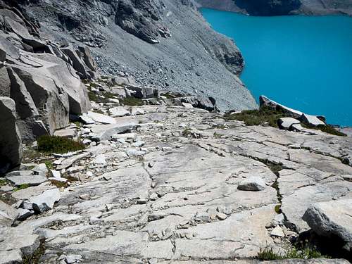
Jade Lake
From No Name Lake the trail descends slightly to Jade Lake where you can see part of Dip Top Peak as well as the small glacier. The trail continues around the east side of Jade Lake. Watch for the correct path which ascends over and around some troublesome cliff bands and then descend the steep dirt to the north shore of Jade Lake. That's it! The end of the trail. You're on your own now.
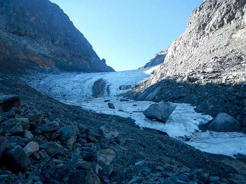 Below The Glacier
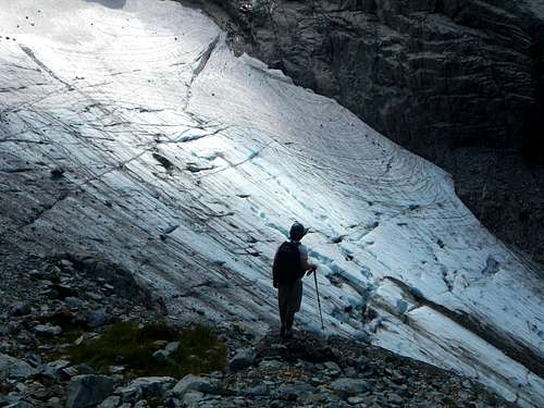
Small Crevases
From Jade Lake ascend scree and glacial silt, or snow in early season, to reach the base of the glacier. Crampons and ice axe or micro-spikes are suggested here. Stay along the eastern edge of the glacier to avoid minor crevasse danger. Once at Dip Top Gap, the scramble route for Dip Top Peak begins. Take a moment to appreciate the view of Pea Soup Lake, Mount Daniel, and the Lynch Glacier.
Dip Top Slab Ramps
Looking Down The Exposed Slab Ramps
From the gap, traverse around to the south side of the east ridge of Dip Top Peak. Ascend some down-sloping slab ramps with a few short class 3 steps. Look for a safe and easy spot to regain the crest of the east ridge and then follow it westward to the summit. Just before the summit is a narrow exposed section. Use extra care here.
The Narrow Exposed Section of Ridge
Getting There / Driving Directions
Drive I-90 east from Snoqualmie Pass or west from Ellensburg and take Exit 80.Proceed north through Roslyn and Ronald and toward Salmon la Sac, 16 miles from Roslyn.
Just before entering this little community, turn right on Forest Road 4330 and drive another 12.5 miles to the end of the road and the Deception Pass trailhead.
Lifetime Accomplishment, 2 Million Feet of Gain, Dip Top Peak
Camping / Red Tape
Numerous camping spots are located along the east shore of Marmot Lake and a few spots can be found at Jade Lake. Please do not camp on sensitive alpine meadows. Display a valid Northwest Forest Pass to park at the trailhead.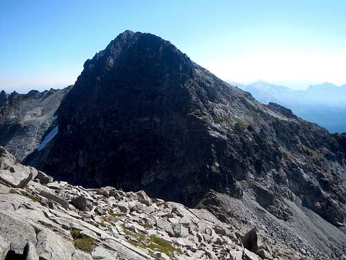
Lynch Peak Looks Intimidating from Dip Top