
|
|
Mountain/Rock |
|---|---|
|
|
44.13337°N / 71.73691°W |
|
|
Grafton |
|
|
Hiking, Mountaineering, Scrambling |
|
|
Spring, Summer, Fall, Winter |
|
|
4293 ft / 1309 m |
|
|
Overview
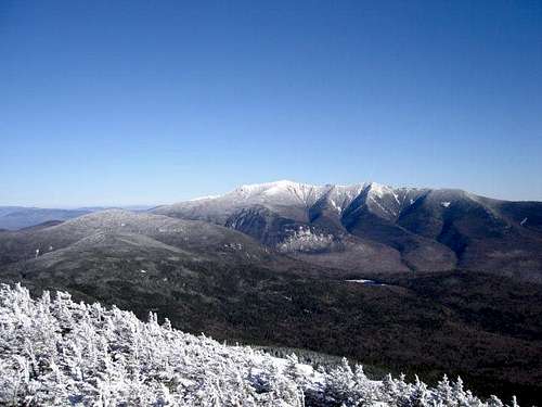
Franconia Ridge from North Kinsman
North Kinsman from Kinsman...
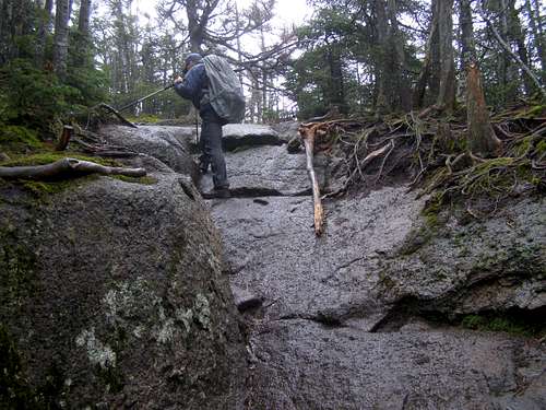
North Kinsman and South Kinsman are typical combined in a dayhike from the east or the west. Many of these trails to reach the summit are often rocky, slabby, and even scrambly in sections and many of them barely have an soil. So expect to be using your hands very once in a while on these trails. Listed below (Thanks WhiteLief, former owner and maintainer) are the many different ways one can head to the summit of both of these peaks.
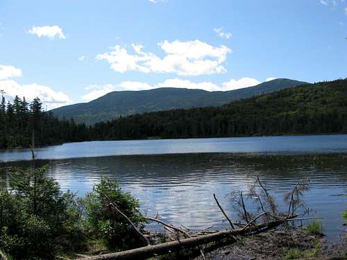
South and North Kinsman rise behind Lonesome Lake
Getting There
Parking lots for several trailheads are available at The Flume, The Basin, and Lafayette Campground along the Franconia Notch Highway (Rte 3/93). From the Flume parking lot, the Cascade Brook Trail is located .8 miles to the north via the bike path. The Basin parking lot is located to the east of the Basin-Cascade Trail. The Lonesome Lake Trail begins at the Lafayette Campground. All three of these trails lead to Lonesome Lake and to the many trails to the Kinsmans from that area.The southern end of the Kinsman Ridge Trail is reached from the height of land along NH Rte. 112, and the northern end is reached from the Cannon Mountain tramway parking lot. White Mountain National Forest fee of $3.00/day for the Rte. 112 parking area.
The Mt. Kinsman Trail is reached at the Franconia-Easton town line on NH Rte. 116.
Route
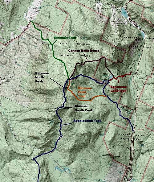
Map of the Routes
Kinsman Ridge Trail This trail runs from Route 112 to the Cannon Mountain Tramway. The section of trail from NH Route 112 to Kinsman Junction is part of the Appalachian Trail, and is blazed in white. Leaving the White Mtn. National Forest parking lot, the trail reaches South Kinsman at 10.0 miles, and North Kinsman at 10.9 miles. Kinsman Junction is reached at 11.5 miles. The Kinsman Ridge Trail continues on over the three Cannonballs, then over Cannon. The trail ends at the tramway at 16.9 miles. The trail is wooded for most of its traverse, except for the summit of South Kinsman, some lookouts along North Kinsman, and the summit of Cannon.
Mount Kinsman Trail This trail runs from the Franconia-Easton town line on NH Route 116. The trail reaches the Kinsman Ridge Trail at 3.7 miles. North Kinsman lies .4 miles to the south along the Kinsman Ridge Trail; South Kinsman lies an additional .9 miles down the ridge.
Cascade Brook Trail This trail runs from the bike path, .8 miles north of The Flume parking area. To the Basin Cascade Trail, 1.5 miles; to the Kinsman Pond Trail, 2.0 miles; to the Fishing Jimmy Trail, 2.8 miles; to the Lonesome Lake Trail, 3.1 miles. The Kinsman Pond Trail and the Fishing Jimmy Trail connect to the Kinsman Ridge Trail just north of North Kinsman.
Basin-Cascade Trail If you like waterfalls, choose this trail. The trail runs from The Basin 1.0 miles to the Cascade Brook Trail. There is actually more of Cascade Brook along this trail, and there are several lovely cascades and waterfalls, and many fine swimming holes.
Lonesome Lake Trail This trail runs from the Lafayette Campground to Lonesome Lake, where you can choose a route to the Fishing Jimmy Trail or Kinsman Pond Trail. Distance from the campground to Lonesome Lake area, 1.2 miles. The Lonesome Lake Trail continues on to the Kinsman Ridge Trail, just north of the third Cannonball, which is reached at 2.3 miles. This junction is 3 miles and three Cannonballs away from the summit of North Kinsman.
Fishing Jimmy Trail Easily the most popular route, part of the Appalachian Trail, and very steep in places. From the Lonesome Lake Trail near Lonesome Lake, 2.0 miles to Kinsman Junction at the Kinsman Ridge Trail, .6 miles north of North Kinsman.
Found along the the trails
Kinsman Pond Trail This trail is for those who love moss and the color green. Much less popular than the Fishing Jimmy Trail, it is one of this author's favorite trails in the Whites. From the Cascade Brook Trail, 2.4 miles to the Kinsman Pond Shelter, 2.5 miles to Kinsman Junction on the Kinsman Ridge Trail, .6 miles north of North Kinsman.
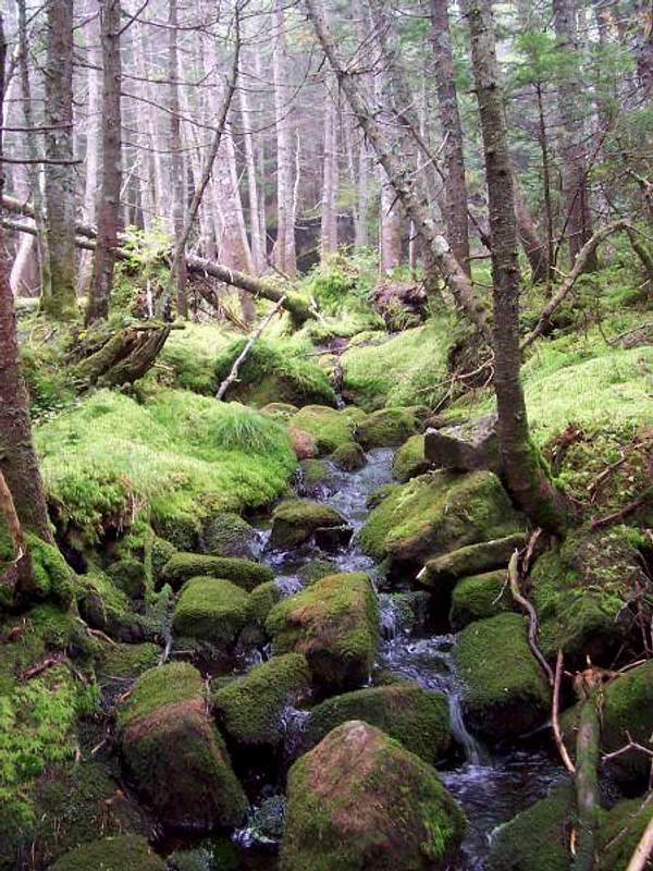
Great moss found along the trail.
Looking for a grand loop? Leave The Basin, follow the Basin-Cascade Trail 1.0 miles to the Cascade Brook Trail; follow the Cascade Brook Trail .5 miles to the Kinsman Pond Trail; follow the Kinsman Pond Trail 2.5 miles to Kinsman Ridge Trail at Kinsman Junction; turn south, climb .6 miles to North Kinsman, continue another .9 miles to S. Kinsman, then reverse course, 1.5 miles back to Kinsman Junction; continue on 3.0 miles over the Cannonballs; OPTION: Add Cannon, which is another 1.0 miles each way (very steep for the first .6 miles) OR follow the Lonesome Lake Trail 1.1 miles to the Cascade Brook Trail at Lonesome Lake; follow the Cascade Brook Trail 1.6 miles to the Basin-Cascade Trail; then follow the Basin-Cascade Trail the last mile back to the Basin.
Red Tape
Parking fees required in the White Mountain National Forest parking lot on Rte. 112. The fee is $3.00 per day. Season passes are available from the ranger stations and various vendors. More information.No camping in Franconia Notch State Park except in the Lafayette Campground.
The National Forest Service has established Forest Protection Areas. Please check with the NFS for the latest restrictions.
In general: No camping above treeline, except in winter and then only when there is two feet of snow on the ground. No camping within 1/4 mile of established huts, campsites, trailhead, or certain roads. Bring a campstove and avoid open fires. Camp away from water.
When to Climb
South Kinsman can be climbed at any time in the year. If you are attempting in winter be very prepared for severe weather conditions such as wind chill -30F and the potential for blizzards. In summer this peak can sometimes be a crowded, humid soup fest, though crowds here are much less than that of neighboring Franconia Ridge and Mount Mooselauke. The best time to really experience this mountain is in late September when the fall colors are really at their prime. This make all of the views on the way up even more spectacular.Camping
Camping is abundant in this area.Lonesome Lake Hut (AMC) is located on--you guessed it--Lonesome Lake, at 2760 feet. Room for 48 guests. No pets. Roughly 1.5 miles from the nearest parking lots. This is a great place for young children, and a boardwalk gets you around the wetter spots for the round-the-lake ramble. For more details, and links to the rates and availability, please go to the AMCLonesome Lake Hut page.
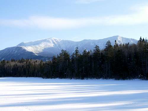
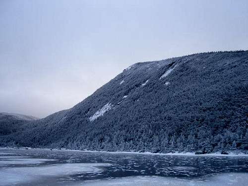
Lonesome Lake in winter
Lafayette Campground is located at the northern end of Franconia Notch on the west side of the highway, at the base of Cannon Mountain. Fee charged. Call 603-745-8391for details, or check the official website for Franconia Notch State Park.
Eliza Brook Shelter (AMC) is located on the Kinsman Ridge Trail at the crossing of Eliza Brook, between Mt. Wolf and Mt. Kinsman.
Kinsman Pond Campsite (AMC) is located at Kinsman Pond near Kinsman Junction. Shelter and three tent platforms. Caretaker in summer; fee charged. Pond water requires treatment! Great views towards the summit of North Kinsman.
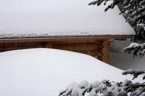
Kinsman Pond Shelter under snow