
-
 7219 Hits
-
 75.81% Score
-
 6 Votes
|
|
Mountain/Rock |
|---|---|
|
|
48.88967°N / 20.15587°E |
|
|
Hiking, Mountaineering |
|
|
Spring, Summer, Fall, Winter |
|
|
6385 ft / 1946 m |
|
|
Overview
Kráľova hoľa (pl „Królewska Hala”, hun. Király-hegy, ger. Königsberg, 1946,1 m n.p.m.) - In translate to English - King`s Meadow, beside Krivan in High Tatras is the second "national" mountain in Slovakia, described in many legends and stories. Kralova hola is situated in the main ridge of the Low Tatras. It is the first, counting from the east, peak reaching over treeline peak in this group and also the highest mountain in the east of these mountains, known sometimes as Kráľovohoľskie Tatry. Geological structure of various rocks: granites, crystalline slates and even limestones. Part of this mountains in the National Park Low Tatras. Treeline sometimes reachinig level 1750 m asl. Upper part is covered by mountain medaows. Since 1960 landmark of the summit is a huge TV relay station with visible from far away transmitter mast. To the station, streamers from the village Šumiac in the valley of the river Hron, leads a narrow road with a length of 11.5 kilometers. The road is closed to public traffic, with the exception of bicycles. Kralova hola is one of the most visited peak of the Low Tatras. It is known for its excellent panorama.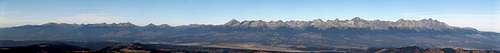
Panorama of Tatras from Kralova Hola
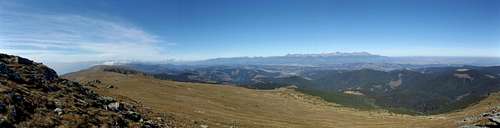
From Kralova Hola toward north
In May 2014 the area was destroyed by a hurricane - called Kalamita. a huge parts of slopes are covered by hollow of trees.
Getting There
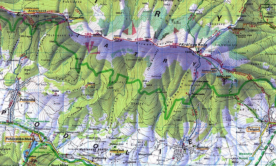
Area is accesible from north or south. From nothe road 67 - Poprad - Roznava, through pass Vernar, from south road 66 from Brezno. Just under Kralova Hola is railway, that we can come here from Kosice or Banska Bystrica to station Telgart. In Telgart is interesting historic railway viaduct and big curve of railway tracks.Route
To Kralova hola leading a few trails. Two of them begins in village Talgart. Its the shortest way to summit. First one marked in green - through Kralova skala, maybe more intersting than red trail, but after Kalamita damages, its very easy to lost correct way and lost. Then we must wade through terrible hollows of trees. Better option is red trail - leading under power lines. Very easy, without any difficulties.From Sumiac is blue marked trail. All above described trails (if we didn`t lost at green) takes no more than 3 - 3,5 hours of ascent. From Sumiac we can also reach summit by bike. Its the highest place in Western Carpathians reachable by this way. Its one more trail, a little bit longer, marked in yelllow, from Vernar Pass.
Red Tape
Upper parts of Kralova Hola is national park, so there are infomations about restrictions.When to Hike
Best time to hiking is early autumn, but we can hike there all year.Camping
Its very easy to find accomodation in villages Sumiac or Telgart. Just ask met capita.External Links
National Park Nizke TatryHiking Map