
|
|
Mountain/Rock |
|---|---|
|
|
39.22950°N / 119.74874°W |
|
|
Carson City |
|
|
Hiking |
|
|
Spring, Fall, Winter |
|
|
6105 ft / 1861 m |
|
|
Overview
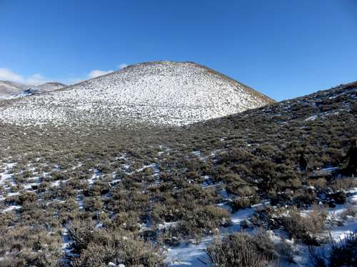
View to the west face of Peak 6105
While easily accessible, it is actually a challenge because it is excessively steep. Roads from the southeast and the north climb up the steep slope towards the summit.
Views are excellent, due its location above Carson City with unobscured views to the south. Views west and north are also excellent.
Peak 6105 and the hills in the Washoe Lake can get snow in winter, but it varies from almost none to a few inches. There was consistent snow on the mountains during the winters of 2009/2010 and 2010/2011, no snow pack for any length of time during 2011/2012 through the winter of 2014/2015. Snow has returned for the winter of 2015/2016. Hiking in winter, even on snow, doesn’t pose a challenge. It is better than hiking on mud. The best months to hike here are October through March. Dry conditions or snow cover are preferred.
Getting There
There are three access points to the Peak 6105. From Reno, there are two BLM trailheads off East Lake Blvd. From Reno either head south on 580 to exit 44 to East Lake Blvd, or take 395 South towards the north entrance to East Lake Blvd.The first access point is from the ranger station southeast of Washoe Lake. The second is 2/3rds of a mile to the west at a BLM trailhead.
From Carson City, take Goni Road which is accessed off of Arrowhead Drive.
Route
From the northern trailheads, both will converge eventually. The basic requirement is to use the 224 dirt access road, which leads to the base of Peak 6105. The BLM trailhead has trails leading up to the 224, and the ranger station parking lot is at the base of the 224 road.Both are the same hiking distance. So after about 1.2 miles, go left off the 224 road to a saddle between Nine Hill 6,077’ and Peak 6105. Once at the base of Peak 6105, head up the steep road or slightly to the right of it and switchback up the hillside.
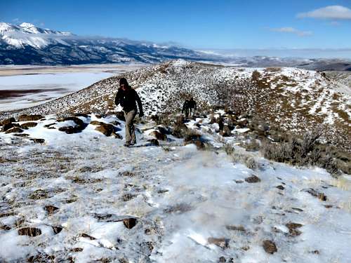
Almost at the summit of Peak 6105
The total distance from either trailhead is 3.5 miles round trip. Depending on the trailhead, the elevation gain is a little over 1,000’. You can add Nine Hill, and come down its west side, and only add ¼ mile total and 317’ of elevation gain.
From Goni road there are a few starting points. For the first one, take Goni Road up to the mine and continue on the road when it turns right uphill away from the mine. After about a tenth of a mile you can park on the side on dirt. A dirt road heads up the south face of Peak 6105 in just under a mile, gaining 1,040’. You can also drive up another mile, and there is a road leading up the east side of Peak 6105 in less than half a mile, gaining 660’.
Finally, you can go all the way up to the turn off to the road that reaches the saddle between Nine Hill and Peak 6105. If parking just off Goni Road, you head up about 0.4 miles to the base of Peak 6105 and then head up to the summit gaining 515’. You can add Nine Hill and do a loop around Nine Hill, taking the road off Nine Hill’s east side back to the parking area covering only 1.5 miles total round trip.
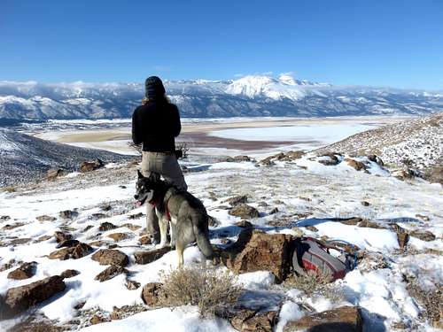
View northwest from Peak 6105