
|
|
Mountain/Rock |
|---|---|
|
|
37.11747°N / 113.48762°W |
|
|
Download GPX » View Route on Map |
|
|
Washington |
|
|
Hiking |
|
|
Spring, Summer, Fall, Winter |
|
|
3250 ft / 991 m |
|
|
Overview
Shinob Kibe (pronounced shin-o-bee kai-bee) is a small mesa overlooking Washington City (a neighboring city of St. George) in southwest Utah. While the ascent is a moderate but steep hike, it is included here for historical reasons. This mountain was one of the sacred peaks of the southern Paiute tribe, a spot they would use as a fortress when other tribes would come raiding. There is an ancient medicine wheel near the summit. In addition, thiis peak is one of three high points in Washington County that has a cement aviation navigation arrow that formerly guided pilots on mail routes from Los Angeles to Salt Lake City.
Shinob Kibe
Getting There
From the Desert Rat outdoor retail store at the corner of St. George blvd and Bluff St., drive east on St. George blvd for 1.7 miles to Interstate 15 . Drive north on I-15 for 1.6 miles to the Washington City exit 10. Turn right on Greensprings Dr. Make an immediate left onto Telegraph/State St., and drive for a little over a mile to S. 300 East. Turn right and follow this road for 1.2 miles (crossing the Virgin river en route.) Shortly after the bridge, turn left onto Indian Springs Dr. Make another immediate left onto Red River Dr. Follow this road (it will become E. Apache Dr.) for .3 miles. Turn left onto Pocahontas drive and continue for .2 miles. Turn left onto Unitah Dr and follow it around a right-hand corner where it becomes Paiute Dr. Follow it to the end of Paiute Dr, pass through a gate onto a dirt road. Drive for 200 feet. The trailhead will be on the right. Park here.
Google Maps Directions here.
Shinob Kibe
Route
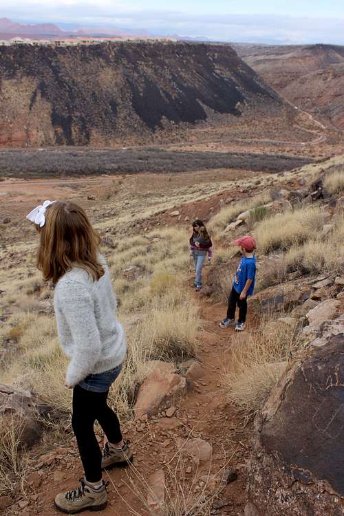
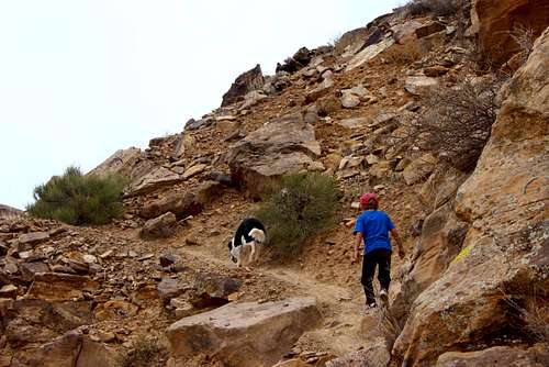
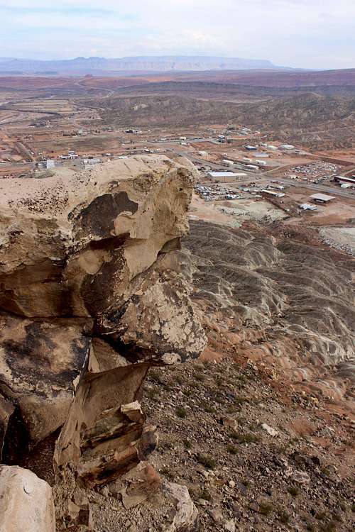
The route is quite simple: follow the trail as it winds its way up the mountainside. It is a well-defined trail and easy to follow. It gains about 600 feet of elevation in approximately .8 miles. After hiking a little over a quarter mile, you will reach a broad ridge marked by a few boulders. Head up the ridge (making sure not to divert, as everything to the west is private property.) Soon you will reach a crumbly section that will require some unpleasant scrambling, but it is short lived. After a few hundred feet, the trail reaches the base of the cliffs that have been towering above you for the entirety of the hike. Traverse east along ledges for a few hundred yards until the trail switchbacks up to the summit plateau. Hike across the flat sagebrush plain. After about .10 miles, the trail crosses a rocky rise. Look to your left and you may see the medicine wheel hiding a few hundred feet in the distance. It is fairly difficult to see, but makes for a nice diversion. Please respect this ancient artifact and do not disturb it. Return to the trail and walk another .10 miles to the summit, where the aviation arrow is. There is a nice summit register in an ammo canister with some detailed information about Shinob Kibe on the back. Make sure you walk out on the "diving board," a rock that juts out into space from the summit. Be very careful though, as this rock narrows to only about a foot wide and there is a several-hundred foot drop beneath your feet.
Shinob Kibe
Red Tape
None, but please respect the privacy of the people who live at the base of the mountain.
When to Climb
Definitely an all-season climb, although in summer it would be advisable to hike it either in the early morning or late evening to avoid the excruciatingly hot temperatures.
Camping
The closest camping would most likely be the Red Cliffs Recreation Area. There is lots of dispersed camping in Washington County on Forest Service and BLM land, but nothing particularly close by.
Add Camping text here.External Links
Nice Facebook page dedicated to Shinob Kibe
Washington County Historical Society page
My video of the hike up Shinob Kibe: