|
|
Mountain/Rock |
|---|---|
|
|
18.76812°N / 145.67323°E |
|
|
Mountaineering |
|
|
Spring, Fall |
|
|
3204 ft / 977 m |
|
|
Overview
Agrihan (also spelled Agrigan) is a large stratovolcano located about 250 miles north of Saipan in the Commonwealth of Northern Mariana Islands (CNMI). Officially at 965 meters (3166 feet) although in 2018 measured at 976 meters (3204 feet), Agrihan is the highest point in the CNMI and all of Micronesia. Based on different topological maps there appears to be two candidates for the true summit of Agrihan with most maps indicating the western summit as the high point. See the "Routes" section for more details.

Getting There
Saipan:
Agrihan:
- Super Emerald - a former ferry boat with a large air-conditioned interior with plenty of room for equipment, supplies and sleeping on benches. US$3500/day
- Kaiyu III - a semi-converted fishing vessel with a medium-sized air-conditioned cabin for equipment, supplies and sleeping on the floor. US$3500/day
- Blue Marlin - a fishing vessel with a clean hold for equipment, supplies and sleeping on the floor. US$2500-$3500/day
- ??? - large research ship with unknown facilities although we heard they are far more comfortable than even the Super Emerald. US$10,000-$11,000/day
M/V Pacific Marine - a WWII landing craft with minimal facilities can carry lots of people/gear and jet fuel if needed.
Routes
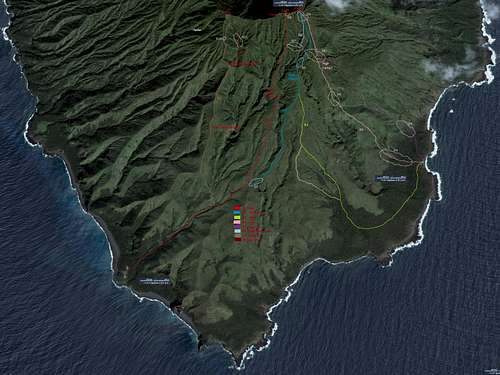
As with most remote, unpopulated areas there are few accurate sources of topological data. The 2014 and 2015 expeditions relied on various topo maps which differed - some indicated a western summit while others indicated an eastern summit as the true high point. The majority of the maps indicated the western summit as the highest. In 2017, new data became available which indicated the eastern summit was the highest. Andy Hatzos was asked to analyze SRTM data (no LIDAR data is available) for the southern portion of the crater rim. His analysis found four potential peaks - P945 (the western summit) and a trio of peaks (P947, P952 and P960) for the eastern summit. Looking at various sources of satellite imagery, potential routes were identified along with possible difficulty areas as seen below:

SouthSouthEast Ridge:
Informally called Stegosaurus Ridge, this is the first ascent route which the Agrihan 2018 Expedition team followed. Ideally you would land at the southeast beach and follow R3 -> R2 to P960 and then traverse the crater rim to P952. Due to weather the southeast beach is usually closed and you must land at the southwest beach. Thus the route is normally done as R1 -> R2 to P960 and then traverse to P952. The route up to P960 is simple hiking with some ravines to pass through. The crater rim traverse from P960 to P952 is Class 4 which should be protected with ropes for safety since the crater rim is fairly narrow. In one part a 30 foot (10 meter) caving ladder was used to climb a side ridge.
SouthSouthWest Ridge:
Informally called Brokeback Ridge, this was the route used in 2014 and 2015, although neither expedition reached P945 and the crater rim. It is best to land at the southwest beach and follow R1 -> R7 to reach P945. The idea was to then traverse the crater rim to P952. It is unknown whether this route would be successful or not. The crater rim traverse from P945 is perhaps doable until you approach P947. When the 2018 expedition explored P947 they encountered a 30-40 foot (10-13 meter) drop similar to what stopped the 2015 expedition from reaching P945; see their trip report for full details.
Red Tape
Saipan:
Agrihan:
When to Climb
The sea crossing is the critical factor as to when you can climb Agrihan. The seas are calmest between May and October although the typhoon season (and heavy rains) is from July to November. This leads to two climbing windows. One in the mid-April to mid-June time frame. The other perhaps in mid-October to early-November.Dangers
- The lower slopes of Agrihan have been taken over by feral pigs which were abandoned in 1990 when the local villagers were evacuated due to increased volcanic activity.
- There are a few feral dogs as well.
- Monitor lizards can also be seen on the lower slopes.
- Your sanity is in danger due to the millions of gnats which infest the entire island, even the upper slopes near the summit. They are non-biting but a great nuisance until sundown when they disappear.
- Using a machete to cut the sword grass leaves many punji sticks which can be painful. You may want to wear tight-weave socks (for the punji sticks) and leather gloves (for the leaves) to protect yourself.
- Open wounds can quickly become infected (any combination of bacterial, viral or fungal) which may lead to extensive treatment and recovery times when you return home.
