
|
|
Mountain/Rock |
|---|---|
|
|
39.93848°N / 120.28458°W |
|
|
Plumas |
|
|
Hiking, Scrambling |
|
|
Spring, Summer, Fall |
|
|
8327 ft / 2538 m |
|
|
Overview

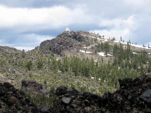
View south from Dixie Mountain
Dixie Mountain is a prominent peak located to the west of Frenchman’s Lake in northeastern California. It has a fire tower on the summit and rocky cliffs on its west side. It has a prominence of 2,407’, ranking it as the 101st most prominent mountain in the state of California.
Frenchman’s Lake is located close enough to Sacramento and Reno to see a good deal of traffic during the spring, summer, and winter months. Dixie Mountain is accessed via a well graded dirt road on the west side of the lake.
Views from the summit are pretty nice. The forests of Plumas County make for a quaint view while Sierra Valley spreads out to the south, with higher peaks rising further south making up the last of the alpine section of the northern Sierra Nevada range. Views to Frenchman’s Lake are decent. Although if wanting a much better view of Frenchman’s Lake, you can bushwhack up from the summit road for a third of a mile to French BM 8,182’, which is the furthest south rocky summit on the Dixie Mountain summit ridge. The views are probably as good as Dixie Mountain, and there is a far better view of Frenchman’s Lake. Consult topographic maps to determine the best path.
Dixie Mountain is typically hiked during fall months before snowfall comes and when fall colors are in bloom. The best months to hike are typically April-May, September-November.
Getting There
Dixie Mountain summit from the south
Reaching Dixie Mountain is pretty straight-forward. The summit road is pretty good for a long stretch, and sees plenty of traffic from 4WD vehicles and ATVs.
To get there from Reno, take US 395 North to Hallelujah Junction (Highway 70). Take Highway 70 west for several miles to Chilcoot. At Chilcoot, follow signs north on 284 to Frenchman’s Lake. About 8 miles up the road, there’s a junction at the south end of the lake. Take a left and drive around Frenchman’s Blvd to the west side of the lake. Dixie Mountain Road is about 6 miles from the junction. It is a half mile past a few cabins seen on the left side of the road.
Dixie Mountain Road goes for about 7 miles ending just below the summit. The end of the road is about an eighth of a mile from the summit tower. Stay on the right side of the rocks and there is a path and stairs leading to the tower.
2WD vehicles can comfortably get 2 ½ miles up the mountain in dry conditions where there is a parking area on the right side of the road. That is about 4 ¾ miles from the summit (with no shortcuts). Although that could easily be cut by a half a mile.
If starting at the parking area for 2WD vehicles (6,535’), it is an elevation gain of about 1,800’ to the summit.
If wanting a little more adventure, the rocky west face can be climbed. To get there, take the same junction at the south end of the lake to Frenchman’s Blvd, but instead drive 3 miles and turn left on Dixie Valley Road. The road is similar in quality to the Dixie Mountain summit road. 2WD may have some trouble at spots, but a standard jeep or SUV will have an easy time, since the road is relatively flat.
Drive approximately 6 ½ miles on Dixie Valley Road and there is a road on the right at 39.9412, -120.3367.
Park here and hike up this road for a quarter mile. Take a junction heading right (basically continuing straight), and continue for another mile. It is about 2 ½ miles or so of bushwhacking, gaining over 2,000’ (over 2,400’ total).