
|
|
Mountain/Rock |
|---|---|
|
|
39.06343°N / 120.2217°W |
|
|
Placer |
|
|
Hiking |
|
|
Summer, Fall |
|
|
8514 ft / 2595 m |
|
|
Overview
Blessed with nearly 400’ of prominence, Peak 8514 is a rocky cliff just off the Ellis Peak Trail near Barker Pass west of Lake Tahoe.
The mountain is overshadowed by its higher neighbor to the east, Ellis Peak 8,740'. However, it is an easy destination for peak baggers who wish to reach two summits during the same hike.
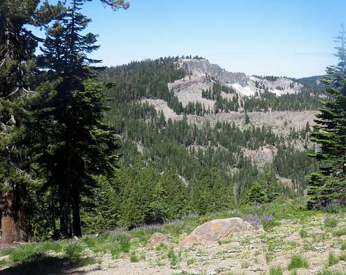
Peak 8514 seen from below Ellis Peak
The Ellis Peak Trail is very close to the Pacific Crest Trail (PCT), but at no time do the two trails connect. The trail to Ellis Peak is separate and is directly intended for Ellis Peak. But the trail climbs steadily initially, all the way up to 25’ below Peak 8514, before descending nearly 400’.
There are excellent views from Peak 8514. There are some views of Lake Tahoe; an appetizer prior to reaching Ellis Peak which has amazing views of Lake Tahoe. But there are also views to the Desolation Wilderness as well as the many surrounding peaks.
The Barker Pass area is best accessed starting in late June through October. Snow levels depend on the season, but West Tahoe mountains get more snow than their eastern counterparts. This is an excellent snowshoeing area when the pass is open. The pass usually opens in early June and closes in early to mid-November.
Getting There
Take Highway 89 to Barker Pass Road on the west side of the road. The road also has a sign for the Blackwood Canyon Sno-Park. If approaching from the south, it is just north of Homewood. If approaching from the north, it is just in Tahoe Pines. The turn-off is right across from the Lake Tahoe shoreline. A sign points to Barker Pass. Drive about 7 miles up to the end of the pavement. This is before you reach Barker Pass. There is a trail on the left and usually cars are parked there. This is the Ellis Peak Trail.
Take the trail for a little over a mile at which point the trail starts to descend. Peak 8514 is just a tenth of a mile off the trail. It is about 1 ¼ miles to the summit gaining 775’. If combining with Ellis Peak, the total distance is about 6 ½ miles, gaining 1,900’ total when considering the round trip.
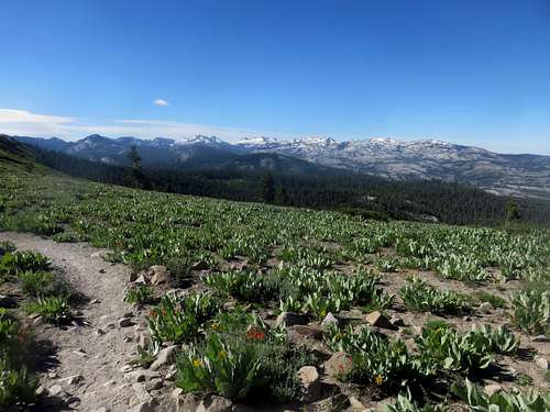
View from near the summit towards the Desolation Wilderness
Red Tape
There is no red tape for Barker Pass during the summer months. The road is usually closed during the spring and winter months. Therefore, it is recommended as a summer destination unless you want a challenging snowshoe experience from lower elevation. If doing so, winter parking at the Blackwood Canyon Sno-Park requires a SNO-PARK PASS.External Links
For more information on road closures, visit the Forest Service Lake Tahoe Basin Management Unit.