
-
 6876 Hits
-
 82.48% Score
-
 15 Votes
|
|
Mountain/Rock |
|---|---|
|
|
47.59005°N / 12.79903°E |
|
|
Hiking, Mountaineering, Trad Climbing |
|
|
Summer, Fall |
|
|
7500 ft / 2286 m |
|
|
Overview
West of Watzmann and Hochkalter rises a huge and oblique karst plateau, bordered by deeply cut in valleys and culminating in its southern parts in some high peaks which show huge and perpendicular rockfaces to the south. This impressive feature is called Reiter Alm, a subarea of Berchtesgaden Alps the highest peak being Stadelhorn (2286 m), a broad, huge and impressive rock at the border between Germany / Bavaria and Austria / Salzburg. The south face of Stadelhorn hosts some of the finest rock climbing routes of Berchtesgaden area.
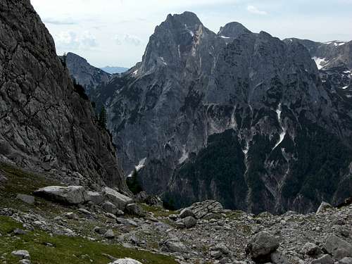 Mighty Stadelhorn and its southwest drop as seen from Ofental route to Hochkalter Mighty Stadelhorn and its southwest drop as seen from Ofental route to Hochkalter |
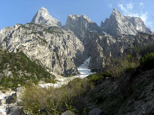
 Stadelhorn (left) and Häuselhorn (center) as seen from Hochkalter summit Stadelhorn (left) and Häuselhorn (center) as seen from Hochkalter summit |
Reiter Alm is a Dachstein limestone plateau, starting to the north at Schwarzbachwacht, bordered to the northwest by Saalach valley and to the east by Ramsau / Hintersee, Grundübelau and Hirschbichl. The northern part of Reiteralm is a low karst plateau, full of dwarf pine thickets and some Alm meadows. The west and east rim of this plateau is built by the lower summits of Drei Brüder, Edelweißlahner and Weitschartenkopf, easy targets for a hiking tour. The southern part shows a more alpine character with the main summits Stadelhorn, Großes Häuselhorn and Wagendrischlhorn and the secondary summits of Mühlsturzhörner and Grundübelhörner to the southeast.
 South faces of Reiter Alm as seen from Birnhorn ski ascent; Stadelhorn to the right, Wagendrischlhorn in the middle, Häuselhorn to the left South faces of Reiter Alm as seen from Birnhorn ski ascent; Stadelhorn to the right, Wagendrischlhorn in the middle, Häuselhorn to the left |
 Grundübelhörner, Mühlsturzhorn and (left) Stadelmauer, the south face of Stadelhorn as seen from Grundübelau Grundübelhörner, Mühlsturzhorn and (left) Stadelmauer, the south face of Stadelhorn as seen from Grundübelau |
All sides of Reiter Alm show steep to perpendicular rock faces, giving an inaccessible aspect to the mountain group. Consequently the four trails from the valleys up to the plateau are all steep and some are secured with fixed steel ropes.
Stadelhorn sits on the south end of Reiter Alm and is the culmination point of a L – shaped ridge, coming from Großes Häuselhorn and Wagendrischlhorn to the northwest and going to Mühlsturzhörner and Grundübelhörner to the southeast and east of Stadelhorn. The summit is separated from Wagendrischlhorn by Mayrberg col which is the only south – north – traverse route of Reiter Alm. All normal routes to Stadelhorn unite there to reach the short and steep ascent of the summit block.
All the normal routes to Stadelhorn are long and demanding trails. The summit block requires some UIAA grade I moves and offers a great view all around Berchtesgaden mountains and to the adjacent group. Being far from belonging to the “high peaks” of Berchtesgaden (Watzmann: 2713 m; Hochkalter: 2607 m) Stadelhorn and the neighbour summits Wagendrischelhorn and Häuselhörner belong nevertheless to the main hiking destinations of Berchtesgaden.


Reiter Alm offers a variety of trails and traverses, many of them going to Stadelhorn. To shorten the in some parts long trails and routes, an alpine club hut, the Neue Traunsteiner Hütte, situated at about 1700 m in the center of the lower part of Reiter Alm, offers food, drinks and lodging.
Getting There
There are four main trailheads for the main ascents to Reiter Alm and Stadelhorn:


Ramsau / Hintersee or Schwarzbachwacht can be reached by car
The next train station to Reiter Alm is Berchtesgaden. Lokal busses number 845 and 846 go to Hintersee trailhead.
Routes Overview
Routes Overview
Stadelhorn Main Routes Overview
East ascent / Wachterlsteig
From Schwarzbachwacht traverse on a good trail (number 470) to the eastern drop of Reiter Alm and ascend it up to a height of about 1500 m. Follow the trail across the lower Reiter Alm Karst plateau, slightly ascending, until you reach Neue Traunsteiner Hütte.
Turn south there and follow the trail up to the col between Wagendrischlhorn and Unterer Plattelkopf, the so called "Rossgasse". Traverse the east side of Wagendrischlhorn (trail number 473) to Mayrbergscharte and use the summit ascent from then on.

South ascent 1 / Böslsteig
Go southwest on Hirschbichlstraße for about 300 m, starting at Hintersee parking area. Böslsteig (number 473) then branches off (signpost) to your right, leading up into the woods in some zigzags. It is first a supply road; at about 1080 m height (Halsgrube) Böslsteig branches off this road to the left and gains the lower slopes of the huge cirque between Grundübelhörner, Mühlsturzhorn, Stadelhorn, Wagendrischelhorn and Plattelköpfe on a near level part of the ascent.


It then ascends very steeply and in some times secured with steel ropes those slopes until it reaches the heights of Reiter Alm at Reiter Steinberg (2060 m, ascent of 1000 m altitude difference).


At Reiter Steinberg turn left on the trail traversing Oberer Plattelkopf (2098 m) and Unterer Plattelkopf (2106 m) to the col between Wagendrischlhorn and Unterer Plattelkopf. Traverse the east side of Wagendrischlhorn (trail number 473)to Mayrbergscharte and use the summit ascent from then on.
South ascent 2 / Schaflsteig
Follow Hirschbichlstraße for about 3,8 km (!) starting at the Hintersee parking area. At about a height of 1080 m Schaflsteig (trail number 473) branches off to the right (signpost) and ascends steeply through woods and dwarf pine zones to the southwest side of Stadelmauer, the huge southwest rock face of Stadelhorn and Großes Mühlsturzhorn.


The route climbs up to the southwest ridge below Stadelhorn and descends shortly to the beginning of the chute up to Mayrbergscharte. The route up to the col is secured with steel ropes and some iron pegs and is very steep.


Use the summit ascent from Mayrbergscharte.
North ascent / Schrecksteig
Schrecksteig (trail number 474) starts at the military supply cable car valley station at Oberjettenberg. It uses first a supply road up to a height of 1000 m. Then a steep zigzag trail continues up to the lower Reiter Alm Karst plateau, northeast of Weitschartenkopf (Schrecksattel).


Follow the near level trail to Neue Traunsteiner Hütte. Turn south there and follow the trail called Rossgasse up to the col between Wagendrischlhorn and Unterer Plattelkopf. Traverse the east side of Wagendrischlhorn to Mayrbergscharte (trail number 473) and use the summit ascent from then on.


West ascent from Mayrberg
There are two route possibilities which can be combined to a round trip.
- Follow the supply road from the parking area in southern and eastern direction. It zigzags up to a height of about 1300 m. Pass by the hunters cabin "Hochgscheid" and follow then the steep trail to the trail junction with Schaflsteig at the lower end of the chute to Mayrbergscharte. Climb up to Mayrbergscharte (secured with pegs and cables) and use the summit ascent from there on.
- Follow the supply roads from the Mayrberg parking area to the north, turn on the trail to Alpaalm (so called Alpa Steig) up to the lower Reiter Alm Karst plateau and proceed on a trail to Neue Traunsteiner Hütte. Turn south there and follow the trail called Rossgasse up to the col between Wagendrischlhorn and Unterer Plattelkopf. Traverse the east side of Wagendrischlhorn (trail number 473) to Mayrbergscharte and use the summit ascent from then on.


Summit ascent
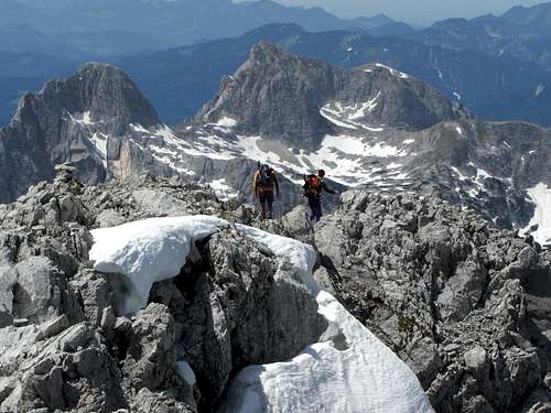
At Mayrberg col turn southsoutheast to the westnorthwest ridge of Stadelhorn and follow the red and white marks over rocks and on scree and meadow ledges up to a steeper part of the ridge. The marked route zigzags up, using ledges, some chutes and short rock faces (UIAA grade I climb) up to the summit zone.


Follow the scree path up to the summit cross.
My recommendation:
Trailhead Hintersee / Ramsau
Ascend Böslsteig, normal route to Wagendrischlhorn, descent on Via ferrata to Mayrberg col, ascend / descend Stadelhorn on the summit route
Descent route Schaflsteig to Grundübelau, nice walk back below the huge rock faces of Grundübelhörner to Hintersee.
A loooooong day! Allow about 9 hours walking time, 1900 m of altitude difference.


Some climbing routes in the south rock face of Stadelhorn:
Fata Morgana, grade 7-
Stoana Zwerg, grade 6 / A0
South Face, grade IV
Red Tape & Accommodation
Red Tape
The german part of Reiteralm belongs to the Berchtesgaden National Park and is a strictly protected zone.
The information center at Hintersee / Ramsau will inform you about regulations within the protected core zone of the national park.
No camping and no fire is allowed within the core zone (upper alpine zone of Reiter Alm).

You find all kind of accommodation at:
Ramsau
Berchtesgaden
Unken
Mountain hut:
Neue Traunsteiner Hütte
Gear & Mountain Condition
Stadelhorn is a summer and autumn hiking tour which requires good boots and normal hikung gear. You need lots of water especially if you don´t pass by Neue Traunsteiner Hütte.
Schafsteig and Böslsteig are narrow and in some parts steep trails.
Böselsteig and the south chute to Mayrbergscharte are partly secured with iron pegs and cables; a helmet can be useful. Via ferrata gear is not a must.
All routes are long and demanding when done in one day. Neue Traunsteiner Hütte offers accommodation. If you plan an overnight stay on the hut you can include some more Reiteralm summits to an interesting round trip.
The climbing routes at Stadelhorn are all difficult and need full climbing gear and a lot of experience.

Current Weather:
<iframe src="https://www.meteoblue.com/de/wetter/widget/three/stadelhorn_deutschland_2829875?geoloc=fixed&nocurrent=0&noforecast=0&days=4&tempunit=CELSIUS&windunit=KILOMETER_PER_HOUR&layout=image" frameborder="0" scrolling="NO" allowtransparency="true" sandbox="allow-same-origin allow-scripts allow-popups allow-popups-to-escape-sandbox" style="width: 460px; height: 595px"></iframe><div><!-- DO NOT REMOVE THIS LINK --><a href="https://www.meteoblue.com/de/wetter/woche/stadelhorn_deutschland_2829875?utm_source=weather_widget&utm_medium=linkus&utm_content=three&utm_campaign=Weather%2BWidget" target="_blank">meteoblue</a></div>
Maps & Guide Book

Maps:
Alpenvereinskarte BY 21; Nationalpark Berchtesgaden, Lattengebirge, Reiteralm; scale 1 : 25.000, edition 2013, UTM grid
Alpenvereinskarte BY 20; Lattengebirge, Reiteralm; Ramsau; scale 1 : 25.000, edition 2015, UTM grid
Landesamt für Vermessung und Geoinformation Bayern, UK50-55, Berchtesgadener Alpen; Bad Reichenhall - Königssee - Hallein - Lofer – Saalfelden, scale 1 : 50.000, edition 2015, UTM grid
Guide Book:
Bergverlag Rudolf Rother, Alpenvereinsführer Berchtesgadener Alpen alpin, edition 2014