
-
 13819 Hits
-
 77.48% Score
-
 8 Votes
|
|
Mountain/Rock |
|---|---|
|
|
48.64440°N / 113.59577°W |
|
|
Glacier |
|
|
9541 ft / 2908 m |
|
|
Overview
Not So Little
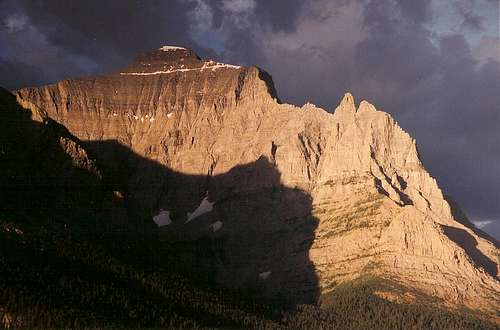
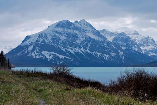
As one enters Glacier National Park via the east entrance of the Going-to-the-Sun Road, it is impossible to ignore the magnificent stretch of peaks that rise to the south behind the waters of St. Mary Lake. The view across the lake is nothing short of spectacular, and serves as a fitting introduction to the alpine splendor that is so readily enjoyed throughout the park. The tallest point visible from this vantage point is Little Chief Mountain, one of only a few Glacier mountains east of the Continental Divide that top out at over 9,500 feet in elevation. Continuing west on the road, travelers experience an even closer view of Little Chief from the scenic and extremely popular Wild Goose Island Overlook. The steep east face is particularly impressive, as it towers nearly 5,000 feet above St. Mary Lake. One can also observe a prominent rock outcropping on the northeast ridge called The Gendarme from this point. The Gendarme is a technical rock climbing endeavor and Glacier's notoriously crumbly sedimentary rock must be taken into consideration for anyone attempting to climb this feature.
Despite being very near the busy Going-to-the-Sun road, all routes to the lofty summit involve long approaches with a hefty amount of elevation gain. Most parties will require at least one very long to ascend and descend this mighty mountain.
Little Chief: What's In a Name?
According to Jack Holterman's Place Names of Glacier National Park, the name Little Chief can be traced back to several men with various ties to the area (1). For one, there was a Blackfeet indian named Little Chief who lived during the mid-19th century. Major Frank North, head of the Pawnee scouts, was said to have a Pawnee named that translated to "Little Chief," and it's possible that George Bird Grinnell named the mountain in his honor. Thomas Dawson, an early 20th century surveyor, interpreter and guide, was known as "Little Chief" by the local Blackfeet. Dawson's name also bears a windswept pass in the Two Medicine region of Glacier. Regardless of the naming origin, anyone who has seen Little Chief Mountain would certainly agree that the name is a bit of a misnomer, as this mountain is by no means small!!!Getting There
Little Chief Mountain is located on the east side of Glacier National Park, and rises directly south of St. Mary Lake. The most practical access points originate from the Going-to-the-Sun Road, which runs for ~50 spellbinding miles from west (West Glacier, MT) to east (St. Mary, MT) through the heart of the park. The two route starting points that will be covered later in this page are nearest the east entrance at St. Mary, a small village that offers lodging, gas, groceries, and restaurants just outside the park boundary on the Blackfeet Indian Reservation. Note that most local services in the area are open seasonally (typically June through the end of September, inquire locally). Park information can be obtained at the St. Mary visitor’s center, which includes a wonderful new exhibit on Native American history in the area.
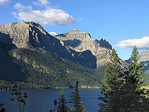
Little Chief Mountain from Going-to-the-Sun Road near Wild Goose Island --- photo by late SP member Saintgrizzly
Routes
Like many peaks in Glacier National Park, there are multiple routes to the summit of Little Chief Mountain. All routes are defined by long approaches and elevation gains exceeding 5000 feet. Even the fastest parties will likely require one long day at minimum to gain the summit. Note that all routes outlined below are also covered by Gordon Edwards in his classic A Climber's Guide to Glacier National Park (see References section for more information).
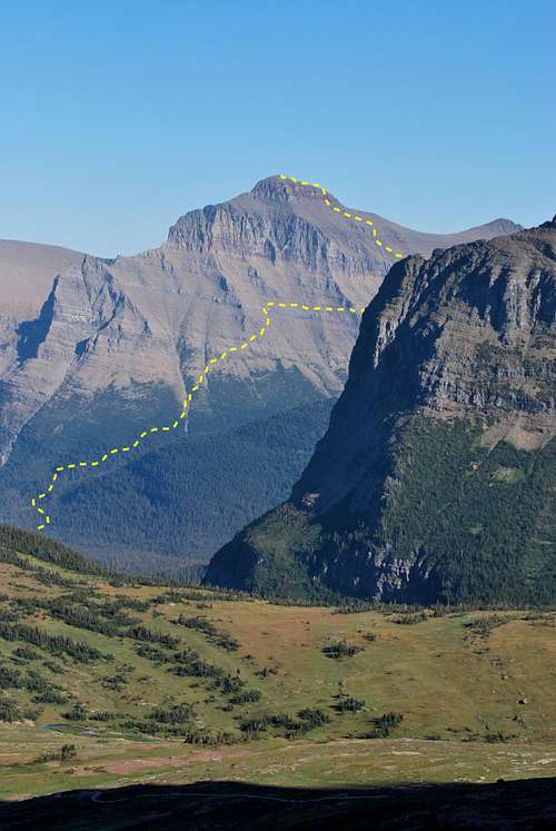
West Slope Route Diagram
West Slope Route
This is the only route I have personal experience with, and as such it will be covered in greater detail. It took our party ~6 hours to summit and ~4.5 hours to descend, so start early and plan on a long day! Starting from the east entrance at St. Mary, travel ~10.5 miles on the Going-to-the-Sun Road to the extremely popular trailhead to St. Mary Falls. Did I mention this trailhead is popular? Short, easy hikes to St. Mary Falls, Virginia Falls, Baring Falls, and Sunrift Gorge all originate from this area, so be forewarned that parking may be difficult to come by on a nice summer day.
Take the trail downhill from the parking lot and bear right at the first trail junction, following signs towards St. Mary and Virginia falls. In ~0.8 miles, the spectacular, tiered gorge at St. Mary Falls is reached. Continue onward for another ~0.7 miles to the large cascade of Virginia Falls. Cross the creek on a footbridge and continue on the St. Mary Lake trail as it heads eastward. This is where the route becomes a little tricky.
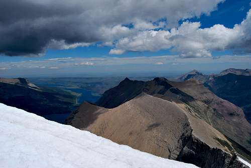
Within 0.5 miles of the creek crossing near Virginia Falls, you will need to leave the trail to your right (south) and bushwhack uphill through the lush forest. Fortunately, this area is frequented by a large elk population, so you are likely to run into one of many well-worn animal trails that will make passage significantly easier. Mountaineers also regularly visit this area, and on my 2010 trip I encountered one trail that had had been marked with orange flagging tape. Trend more or less directly to the south, and expect to spend the next 1,000 vertical feet fighting your way through vegetation before encountering more open terrain. The goal is to gain the large drainage on the northwest flank of Little Chief. Once in the drainage, make an ascending traverse to the south over a mix of ledges, talus and scree. A prominent band of slick, grey rock called the algal reef (located above 7,500 feet in elevation) will be visible in the cliffs high above; the crux of the climb entails finding a passable break the in cliffs to gain game trails that traverse along wide ledges just above the reef. The algal reef is significantly less crumbly than other rock layers found throughout the park, which has its advantages and disadvantages… On one hand, holds are much more solid, but since the rock is less crumbly it may prove challenging to find any breaks less than class III in difficulty. Once you are above the reef, follow game trails in a southward direction as you gain elevation and wrap around Little Chief beneath the sheer towering summit cliffs on the left.
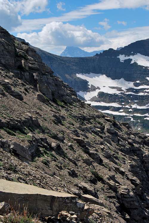
traverse above the algal reef

West Slope Route - Google Earth Overview
The expansive summit vista includes a bird’s eye view of the glaciated meadows near Red Eagle Pass. The meadows near the pass were once very popular with visitors; backcountry parties would ride horses along a well-maintained trail up Red Eagle Creek to the expansive meadows and glaciers near the pass. However, the trail has not been maintained since World War II, so now it requires a multi-day ridge walk and/or bushwhack to reach this marvelous area. Other interesting sites viewed from the summit include Logan Pass, Blackfoot-Jackson Glacier Basin, the peaks around St. Mary Lake, and an unnamed tarn tucked away in a cirque to the southeast. Make every attempt to retrace your route on the descent.
Red Eagle-Mahtatopa-Little Chief Traverse
The long ridge leading to Red Eagle Mountain
1) Continue on the trail to Red Eagle Lake. Cross back over the creek on a second large suspension bridge, and in ~2.5 miles the campground at the foot of the lake will be reached. Carefully ford the outlet of the lake and bushwhack towards the east slope of Red Eagle Mountain. An obvious route up the east shoulder, visible from many vantage points along the Red Eagle Trail, provides access to the mountain’s upper slopes. Several false summits are passed prior to reaching the actual summit of Red Eagle Mountain.
2) Take the fork to the right on the St. Mary Lake Trail. In 1.5 - 2 miles, the trail passes underneath the north face of Red Eagle Mountain. There are multiple class II/III routes up through the cliffs. This route is highlighted in detail by Summitpost member jimegan, and I encourage you to consult his trip report page for more information.
I should also note that it is possible to cut off a minimum of 5 miles of hiking by using a boat to cross St. Mary Lake. Rentals and a boat launch area are offered by the Glacier Park Boat Company at Rising Sun. Inquire locally or visit their website for more information: http://glacierparkboats.com.
Regardless of the approach, once the summit ridge of Red Eagle Mountain is gained, it’s easy ridge walking and route finding over to the summit of Mahtatopa Mountain. Humorously, Gordon Edwards has the following to say about Mahtatopa Mountain: "Because the peak is lower than Red Eagle (and Little Chief), it would appear that the only reasons for climbers to visit its summit would be 1: Because it is there, or 2: because they cannot traverse from Red Eagle to Little Chief without climbing Mahtatopa en route" (2). After the necessary climb of Mahtatopa, continue on the ridge to Little Chief. Options for the descent include retracing your steps to Red Eagle Mountain, or descending towards Almost-a-Dog Mountain or the St. Mary Falls Trailhead.
 East face of Little Chief in May
Traverse from Almost-a-Dog Pass
It is also possible to traverse from Almost-a-Dog Pass over to Little Chief Mountain. However, the approach is significantly longer and more complicated than the 2 routes previously outlined, and most parties will require several days to complete. There are very few established campgrounds along any of these routes, so you're best to inquire locally with the NPS rangers about the prospects of obtaining an undesignated campsite. I am aware of 4 routes that lead to Almost-a-Dog Pass:
1) Norris Traverse starting from Cut Bank Campground. Plan for a minimum of 2 days on this route that involves climbs of Triple Divide Peak and Norris Mountain before descending into Red Eagle Pass. A steep, often snow-filled couloir leads from the meadows up to Almost-a-Dog Pass.
2) Follow the old trail from Red Eagle Lake up to Red Eagle Pass. This trail has not been maintained since World War II, but animals and mountaineers still use this route. Expect lots of route finding and bushwhacking.
3) From Virginia Falls, it is possible to follow Virginia Creek up and around a glorious unnamed waterfall that drains the Blackfoot Glacier Basin. The route hooks around the north of Almost-a-Dog Mountain before reaching the pass. Plan on one very, very long day to reach Almost-a-Dog Pass.
4) By hiking to Gunsight Lake, one can take the old Jackson Glacier Overlook Trail to the large lateral moraine guarding Jackson Glacier. A complicated, arduous route across the expansive Jackson-Blackfoot Glacier Basin leads to Almost-a-Dog Pass. Plan on one very, very long day to reach the pass.
From the pass, one can climb Almost-a-Dog Mountain and and/or traverse eastward along the ridge to Little Chief’s summit.
East Face
Gordon Edwards describes a technical route up the steep east face that involves multiple class IV and V pitches. He also tells of being struck by lightning on the summit after climbing this route (solo!), so consult his Climber's Guide to Glacier National Park for an interesting mountaineering story in addition to more detailed route information.
When to Climb
Due to extreme winters along the Continental Divide, problematic snow can linger on trails and mountain slopes well into July and August. Hence, the prime climbing season in Glacier is rather short, often beginning in June and lasting into late September/early October. However, some lower peaks and south facing slopes can be safely attempted much earlier in the season. Your best best is to inquire locally about snowpack and weather conditions. I use the NOAA for detailed weather forecasts and snowpack information of the greater Glacier area; check out their website for more information: NOAA.gov.Snow will likely be present on parts of the West Slope Route well into June. It’s best to inquire locally, or obtain a visual of the route from the Going-to-the-Sun Road east of Logan Pass prior to setting out on a climb.
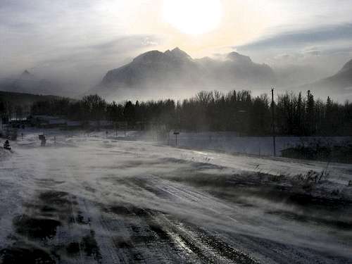
Fierce winter winds in St. Mary. Red Eagle (L) and Little Chief (R) visible in the distance. --- photo by late SP member Saintgrizzly
Car camping and motels/cabins are available at nearby Rising Sun. The campground has 84 sites and is operated on a first-come, first-served basis. Note the campground is extremely busy during the summer months; on most days it will fill by noon at latest. As of November 2016, rates were $20/night. Information on historic campground fill times, reservations and camping regulations can be found on the NPS camping webpage. The Rising Sun Motor Inn is operated by Xanterra and offers rustic motel rooms and cabins. Visit Xanterra’s website for more information.
The NPS also operates the St. Mary Campground (some sites are reservable) near the east entrance of the Going-to-the-Sun Road. The small village of St. Mary offers a KOA campground, in addition to other campgrounds, cabins, and motels.
There are 2 backcountry sites at Red Eagle Lake that would serve as a great jumping point for the Red Eagle-Mahtatopa-Little Chief Traverse. Red Eagle Foot would be the most practical place to start; however, there are no fires allowed. The site at the head of the lake allows campfires, but you’ll add extra trail time hiking along the shore of Red Eagle Lake. Note that a permit is required for all backcountry stays in Glacier National Park. As of November 2016, permits are $7 per person per night and can be obtained at various visitor’s centers. There is an advance reservation system (and associated fee), or sites can be obtained on a walk-up basis. Please visit the NPS backcountry camping webpage for more detailed information.
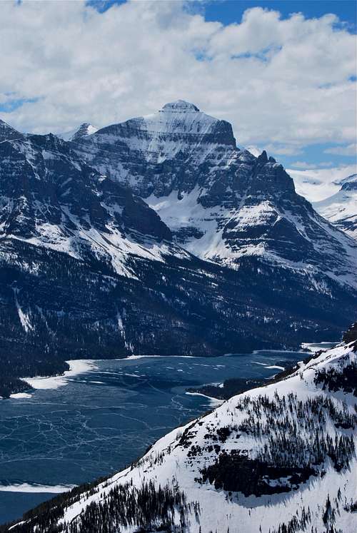
Little Chief visible at extreme right across the meadows at St. Mary
View across St. Mary Lake, Little Chief at far right
Red Tape, Safety, Wildlife, etc.
Entrance Fees
A fee is required for all persons entering Glacier National Park. As of November 2016, single vehicle rates are $30 for a seven day pass, or $45 for an annual park pass (increasing to $50 in January 2017). A lower fee is charged for hikers and bikers; please visit the NPS fees webpage for a full explanation of the entrance fees.
Seasonal Closures
Glacier is subject to extreme winter weather conditions, and as such, much of the park is virtually inaccessible for the majority of the year. The Going-to-the-Sun Road is typically open in its entirety from mid-June to mid-September, and many of the developed areas of the park (including the historic lodges and most of the campgrounds) operate for a short window as well. Information on the operational status of front country campgrounds and park roads can be found by clicking on the hyperlinks.
Glacier Rock Grading
Due to the sedimentary nature of the rock in Glacier National Park, unique rock grading systems have been established by both Gordon Edwards and the Glacier Mountaineering Society. Please refer to the Glacier National Park Rock & Grading Systems Summitpost page (authored by Fred Spicker and Saintgrizzly) or the website of the Glacier Mountaineering Society for detailed information. If you are new to climbing in Glacier, I highly recommend checking out this info before attempting any climbs in the park. Oh, and don't forget to wear your climbing helmet!
A Climber's Guide to Glacier National ParkPick up a copy of Gordon Edwards' classic A Climber's Guide to Glacier National Park. It's an absolute must for anyone who wants to safely venture to one of the park's many accessible mountain summits. Edwards spent many years as a seasonal ranger in Glacier, where he developed a deep passion for exploring the park's mountains and sharing its splendors with others. The book provides a fantastic history of climbing in Glacier, and his detailed and colorful route descriptions are a fantastic introduction to off-trail hiking and climbing in the park.
Hey bear!!!
The park is home to lots of potentially dangerous wildlife, including moose, black bear, grizzly bear, and mountain lion. Hike loud, carry bear deterrent spray (and know how to use it!), check local trail postings (for area warnings/closures) and let someone know your intinerary before heading out into the park. Also, note that special precautions are in place in all front and back country campgrounds to limit human-bear encounters. Regulations are posted everywhere (picnic tables, ranger stations, bathrooms) and it is every visitor's responsibility to take them seriously. Remember, a FED BEAR IS A DEAD BEAR! Please visit the NPS camping webpage for more detailed information.
External Links
Visit the FANTASTIC Glacier National Park page, a labor of love by late Summitpost member Saintgrizzly (R.I.P.), or the NPS webpage for more detailed information on "The Crown of the Continent".
References
1. Holterman, J. (2006). Place Names of Glacier National Park (3rd Edition). Helena, MT: Riverbend Publishing.
2. Edwards, J. (1995). A Climber's Guide to Glacier National Park (1st edition published in 1961). Helena, MT: Falcon Press Publishing Co., Inc.
Special Thanks
A special thanks to Bob Sihler and the late Saintgrizzly for their photographic contributions to this page.